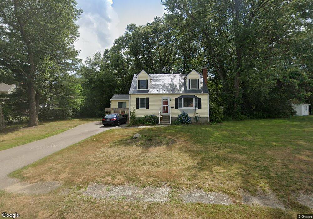
31 Connie Dr Foxboro, MA 02035
Estimated Value: $598,000 - $626,000
2
Beds
3
Baths
1,365
Sq Ft
$449/Sq Ft
Est. Value
About This Home
This home is located at 31 Connie Dr, Foxboro, MA 02035 and is currently estimated at $612,362, approximately $448 per square foot. 31 Connie Dr is a home located in Norfolk County with nearby schools including Foxborough High School, Foxborough Regional Charter School, and The Sage School.
Ownership History
Date
Name
Owned For
Owner Type
Purchase Details
Closed on
Jun 19, 2019
Sold by
Melega Lori and Eagleston Brian
Bought by
Abcl Llc
Current Estimated Value
Home Financials for this Owner
Home Financials are based on the most recent Mortgage that was taken out on this home.
Original Mortgage
$245,000
Outstanding Balance
$203,247
Interest Rate
4%
Mortgage Type
New Conventional
Estimated Equity
$409,115
Purchase Details
Closed on
Nov 24, 2017
Sold by
Eagle Lt and Cuddy
Bought by
Belcher Karen and Eagleston Robert
Create a Home Valuation Report for This Property
The Home Valuation Report is an in-depth analysis detailing your home's value as well as a comparison with similar homes in the area
Home Values in the Area
Average Home Value in this Area
Purchase History
| Date | Buyer | Sale Price | Title Company |
|---|---|---|---|
| Abcl Llc | -- | -- | |
| Belcher Karen | -- | -- |
Source: Public Records
Mortgage History
| Date | Status | Borrower | Loan Amount |
|---|---|---|---|
| Open | Abcl Llc | $245,000 |
Source: Public Records
Tax History Compared to Growth
Tax History
| Year | Tax Paid | Tax Assessment Tax Assessment Total Assessment is a certain percentage of the fair market value that is determined by local assessors to be the total taxable value of land and additions on the property. | Land | Improvement |
|---|---|---|---|---|
| 2025 | $6,740 | $509,800 | $217,400 | $292,400 |
| 2024 | $6,440 | $476,700 | $217,400 | $259,300 |
| 2023 | $6,240 | $439,100 | $207,000 | $232,100 |
| 2022 | $6,082 | $418,900 | $198,000 | $220,900 |
| 2021 | $5,741 | $389,500 | $180,000 | $209,500 |
| 2020 | $5,560 | $381,600 | $180,000 | $201,600 |
| 2019 | $5,296 | $360,300 | $171,400 | $188,900 |
| 2018 | $5,203 | $357,100 | $171,400 | $185,700 |
| 2017 | $4,915 | $326,800 | $160,200 | $166,600 |
| 2016 | $4,899 | $330,600 | $154,100 | $176,500 |
| 2015 | $4,659 | $306,700 | $130,200 | $176,500 |
| 2014 | $4,558 | $304,100 | $127,600 | $176,500 |
Source: Public Records
Map
Nearby Homes
- 89 Oak St
- 170 Cannon Forge Dr
- 132 Cannon Forge Dr
- 9 Independence Dr Unit 9
- 186 Mechanic St
- 35 Independence Dr Unit 35
- 14 Winter St Unit B
- 18 Winter St Unit E
- 12 Community Way
- 1 Roseland St Unit A-1
- 1 Eisenhauer Ln
- 84 Cocasset St Unit A6
- Lot One Old Wolomolopoag St
- Lot Two Old Wolomolopoag St
- 11 W Belcher Rd Unit 2
- 14 Foxhill Rd
- 73 Ridge Rd
- 5 Chase Dr
- 668 S Main St
- 24 Mechanic St