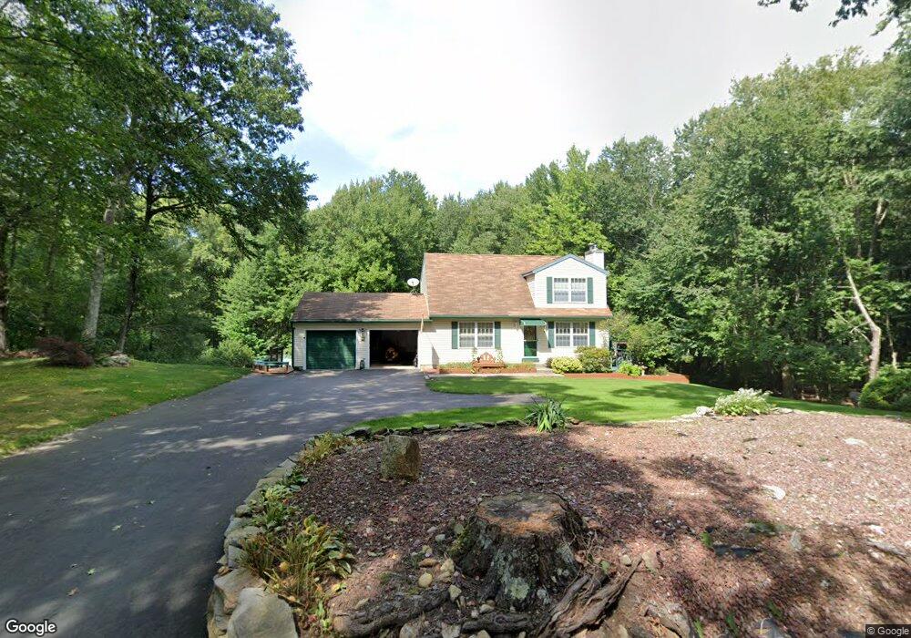
31 Dunn Rd Coventry, CT 06238
Estimated Value: $404,493 - $483,000
2
Beds
2
Baths
1,509
Sq Ft
$290/Sq Ft
Est. Value
About This Home
This home is located at 31 Dunn Rd, Coventry, CT 06238 and is currently estimated at $438,123, approximately $290 per square foot. 31 Dunn Rd is a home located in Tolland County with nearby schools including Coventry Grammar School, George Hersey Robertson School, and Capt. Nathan Hale School.
Ownership History
Date
Name
Owned For
Owner Type
Purchase Details
Closed on
Oct 1, 2004
Sold by
Jeffrey James and Jeffrey Donna
Bought by
Dietz Suzanne
Current Estimated Value
Purchase Details
Closed on
Oct 27, 1993
Sold by
Madred Corp
Bought by
Jeffrey James and Kupec Donna Mae
Create a Home Valuation Report for This Property
The Home Valuation Report is an in-depth analysis detailing your home's value as well as a comparison with similar homes in the area
Home Values in the Area
Average Home Value in this Area
Purchase History
| Date | Buyer | Sale Price | Title Company |
|---|---|---|---|
| Dietz Suzanne | $259,900 | -- | |
| Jeffrey James | $129,000 | -- | |
| Dietz Suzanne | $259,900 | -- | |
| Jeffrey James | $129,000 | -- |
Source: Public Records
Mortgage History
| Date | Status | Borrower | Loan Amount |
|---|---|---|---|
| Open | Jeffrey James | $166,500 | |
| Closed | Jeffrey James | $29,634 | |
| Closed | Jeffrey James | $175,000 |
Source: Public Records
Tax History
| Year | Tax Paid | Tax Assessment Tax Assessment Total Assessment is a certain percentage of the fair market value that is determined by local assessors to be the total taxable value of land and additions on the property. | Land | Improvement |
|---|---|---|---|---|
| 2025 | $6,358 | $267,600 | $70,500 | $197,100 |
| 2024 | $5,616 | $168,600 | $59,100 | $109,500 |
| 2023 | $5,351 | $168,600 | $59,100 | $109,500 |
| 2022 | $5,252 | $168,600 | $59,100 | $109,500 |
| 2021 | $5,252 | $168,600 | $59,100 | $109,500 |
| 2020 | $5,255 | $168,600 | $59,100 | $109,500 |
| 2019 | $5,426 | $168,500 | $59,100 | $109,400 |
| 2018 | $5,062 | $157,200 | $59,100 | $98,100 |
| 2017 | $5,030 | $157,200 | $59,100 | $98,100 |
| 2016 | $4,905 | $157,200 | $59,100 | $98,100 |
| 2015 | $4,905 | $157,200 | $59,100 | $98,100 |
| 2014 | $4,942 | $173,600 | $72,500 | $101,100 |
Source: Public Records
Map
Nearby Homes
- 93 Dockerel Rd
- 0 Mile Hill Rd
- 64 Columbine Rd
- 15 Elm Rd
- 16 Higgins Way
- 279 Mark Dr
- 39 Josephine Way
- 395 Grant Hill Rd Unit Lot21
- 395 Grant Hill (Mill Race Drive) Lot #21 Rd
- 7 Laurelwood Ln Unit Lot 15
- 12 Laurelwood Ln Unit lot 8
- 38 Josephine Way
- 21 Josephine Way
- 32 Josephine Way
- 26 Josephine Way
- 5 Laurelwood Ln Unit lot 16
- 37 Wolf Hill Rd Unit Lot 40
- 37 Wolf Hill Lot (#40) Rd
- 23 Neville St
- 0 Boston Turnpike Unit 24128587
- LOT 5 Dunn Rd
- Lot 3 Dunn Rd
- 60 Dunn Rd
- Lot 1 Dunn Rd
- 10 Dunn Rd
- 73 Dunn Rd
- 0 Dunn Rd
- 1063 Bread and Milk St
- 1045 Bread and Milk St
- 535 Mile Hill Rd
- 72 Skyview Dr
- 20 Skyview Dr
- 1028 Bread and Milk St Unit B
- 1028 Bread and Milk St
- 1028 Bread and Milk St Unit 2
- 1028 Bread and Milk St Unit 1
- 42 Skyview Dr
- 66 Skyview Dr
- 136 Dunn Rd
- 48 Heather Ln
Your Personal Tour Guide
Ask me questions while you tour the home.