D
Seller's Agent in 2025
David Willis
Willis Real Estate
(207) 839-3390
60 in this area
146 Total Sales
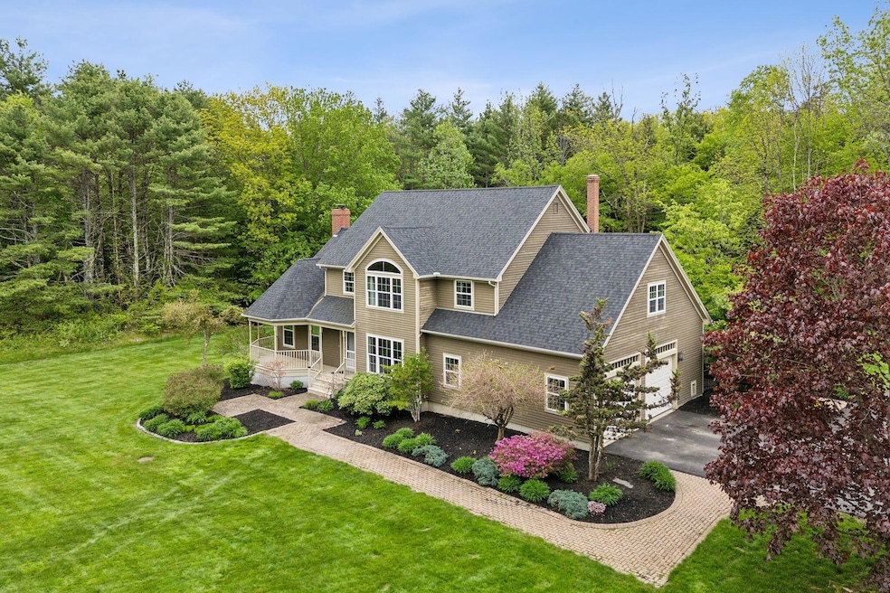
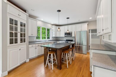
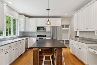


Tucked away on an exceptionally private 3.24-acre lot, this stately Colonial offers the perfect blend of charm, space, and serenity—just 1.5 miles from Gorham Village. Set in a quiet 10-home subdivision, this well maintained residence welcomes you with a classic front farmer's porch, ideal for relaxing and taking in the expansive front yard, framed by mature trees for unmatched privacy. Inside, the grand front staircase makes a stunning first impression, leading to a thoughtfully designed second floor featuring three spacious bedrooms. The highlight is an impressive primary suite with two walk-in closets and a luxurious full bath complete with a Jacuzzi tub. One of the secondary bedrooms was originally two rooms and could easily be converted back to create a fourth bedroom. The first floor is designed for both everyday living and exceptional entertaining. A large, open kitchen flows effortlessly into a front-to-back living room with soaring cathedral ceilings and a striking stone fireplace. A formal dining room adds elegance, while a well-equipped mudroom includes a half bath that conveniently services the pool and outdoor spaces. Step out back to your own private oasis—an expansive deck overlooks a fully fenced, in-ground pool area surrounded by mature landscaping and hardscaping, perfect for summer gatherings or quiet mornings by the water. Additional features include a large basement with a partially finished space ideal for a playroom, home gym, or office. The unfinished portion of the basement offers ample built-in storage shelves, a dedicated workshop bench, and abundant additional storage space, along with convenient access to all the home's utilities. If you're looking for space, comfort, and true privacy with close proximity to Gorham Village amenities, this home is a must-see. Showings begin at the Open House on Sunday, 5/25 from 11:20 AM - 1:00 PM.
| Date | Type | Sale Price | Title Company |
|---|---|---|---|
| Warranty Deed | $863,000 | None Available | |
| Warranty Deed | $863,000 | None Available | |
| Interfamily Deed Transfer | -- | -- | |
| Warranty Deed | -- | -- | |
| Interfamily Deed Transfer | -- | -- |
| Date | Status | Loan Amount | Loan Type |
|---|---|---|---|
| Open | $760,500 | Purchase Money Mortgage | |
| Closed | $760,500 | Purchase Money Mortgage | |
| Previous Owner | $342,000 | New Conventional | |
| Previous Owner | $0 | New Conventional |
| Date | Event | Price | List to Sale | Price per Sq Ft |
|---|---|---|---|---|
| 06/18/2025 06/18/25 | Sold | $863,000 | +8.0% | $284 / Sq Ft |
| 05/22/2025 05/22/25 | For Sale | $799,000 | -- | $262 / Sq Ft |
| Year | Tax Paid | Tax Assessment Tax Assessment Total Assessment is a certain percentage of the fair market value that is determined by local assessors to be the total taxable value of land and additions on the property. | Land | Improvement |
|---|---|---|---|---|
| 2025 | $8,821 | $596,000 | $108,800 | $487,200 |
| 2024 | $8,761 | $596,000 | $108,800 | $487,200 |
| 2023 | $8,195 | $596,000 | $108,800 | $487,200 |
| 2022 | $7,659 | $596,000 | $108,800 | $487,200 |
| 2021 | $7,001 | $360,900 | $88,800 | $272,100 |
| 2020 | $6,857 | $360,900 | $88,800 | $272,100 |
| 2019 | $6,839 | $360,900 | $88,800 | $272,100 |
| 2018 | $6,568 | $360,900 | $88,800 | $272,100 |
| 2017 | $6,171 | $360,900 | $88,800 | $272,100 |
| 2016 | $6,139 | $361,100 | $89,000 | $272,100 |
| 2015 | $5,886 | $361,100 | $89,000 | $272,100 |
| 2014 | $5,832 | $335,200 | $81,800 | $253,400 |
| 2013 | $5,799 | $335,200 | $81,800 | $253,400 |
D
Seller's Agent in 2025
David Willis
Willis Real Estate
(207) 839-3390
60 in this area
146 Total Sales
P
Seller Co-Listing Agent in 2025
Paul Willis
Willis Real Estate
(207) 839-3390
35 in this area
86 Total Sales

Buyer's Agent in 2025
Scott Townsend
Keller Williams Realty
(207) 252-0720
16 in this area
520 Total Sales
K
Buyer Co-Listing Agent in 2025
Kathy Harvey-Brown
Keller Williams Realty
(207) 939-6195
7 in this area
97 Total Sales
Source: Maine Listings
MLS Number: 1623655
APN: GRHM-000045-000019-000006
Disclaimer: Certain information contained herein is derived from information provided by parties other than Homes.com. All information provided is deemed reliable, but is not guaranteed to be accurate and should be independently verified.
![]() Listing data is derived in whole or in part from Maine Real Estate Information System, Inc. (d/b/a Maine Listings) and is for consumers' personal, noncommercial use only. Dimensions are approximate and not guaranteed. All data should be independently verified.
Listing data is derived in whole or in part from Maine Real Estate Information System, Inc. (d/b/a Maine Listings) and is for consumers' personal, noncommercial use only. Dimensions are approximate and not guaranteed. All data should be independently verified.
© 2026 Maine Real Estate Information System, Inc. All Rights Reserved. Equal Housing Opportunity.
Homes.com, LLC, 17600 Laguna Canyon Rd Irvine, CA 92618 (888)-952-6393
![]()
Ask me questions while you tour the home.