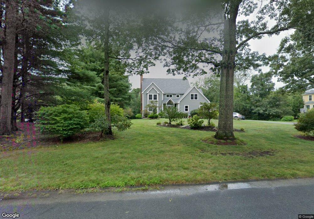
31 Highridge Rd Westport, MA 02790
Estimated Value: $899,000 - $1,030,000
4
Beds
3
Baths
2,772
Sq Ft
$344/Sq Ft
Est. Value
About This Home
This home is located at 31 Highridge Rd, Westport, MA 02790 and is currently estimated at $952,845, approximately $343 per square foot. 31 Highridge Rd is a home located in Bristol County with nearby schools including Alice A. Macomber Primary School, Westport Elementary School, and Westport Middle-High School.
Ownership History
Date
Name
Owned For
Owner Type
Purchase Details
Closed on
Jun 14, 2007
Sold by
Nadeau Brian and Nadeau Yolanta
Bought by
Pickering Andrew L and Pickering Kristi J
Current Estimated Value
Home Financials for this Owner
Home Financials are based on the most recent Mortgage that was taken out on this home.
Original Mortgage
$412,250
Interest Rate
6.19%
Mortgage Type
Purchase Money Mortgage
Purchase Details
Closed on
Jun 10, 1993
Sold by
Security Atlantic Rt and Carrigg Paul T
Bought by
Nadeau Brian and Nadeau Yolanta
Create a Home Valuation Report for This Property
The Home Valuation Report is an in-depth analysis detailing your home's value as well as a comparison with similar homes in the area
Home Values in the Area
Average Home Value in this Area
Purchase History
| Date | Buyer | Sale Price | Title Company |
|---|---|---|---|
| Pickering Andrew L | $485,000 | -- | |
| Nadeau Brian | $71,250 | -- |
Source: Public Records
Mortgage History
| Date | Status | Borrower | Loan Amount |
|---|---|---|---|
| Open | Nadeau Brian | $396,900 | |
| Closed | Nadeau Brian | $412,250 | |
| Previous Owner | Nadeau Brian | $50,000 |
Source: Public Records
Tax History Compared to Growth
Tax History
| Year | Tax Paid | Tax Assessment Tax Assessment Total Assessment is a certain percentage of the fair market value that is determined by local assessors to be the total taxable value of land and additions on the property. | Land | Improvement |
|---|---|---|---|---|
| 2025 | $6,739 | $904,600 | $305,900 | $598,700 |
| 2024 | $6,039 | $781,200 | $260,600 | $520,600 |
| 2023 | $5,982 | $733,100 | $250,600 | $482,500 |
| 2022 | $5,600 | $660,400 | $233,300 | $427,100 |
| 2021 | $5,381 | $624,200 | $216,500 | $407,700 |
| 2020 | $4,648 | $551,400 | $209,700 | $341,700 |
| 2019 | $4,649 | $562,100 | $225,300 | $336,800 |
| 2018 | $4,368 | $534,600 | $201,500 | $333,100 |
| 2017 | $4,269 | $535,600 | $201,500 | $334,100 |
| 2016 | $3,953 | $499,800 | $201,500 | $298,300 |
| 2015 | $3,876 | $488,800 | $205,300 | $283,500 |
Source: Public Records
Map
Nearby Homes
- 73 White Oak Run
- 47 Fallon Dr
- 0 Hidden Glen Ln
- 118 Charlotte White Rd Extension
- Lot 0 Marcotte
- 920 Drift Rd
- 8 Strawberry Ln
- 2 Slades Farm Ln
- 225 Hixbridge Rd
- 118 Charlotte White Rd
- 7 Village Way
- 8 Village Way
- 837 Main Rd
- 15 Village Way
- 4 Main Rd
- 1150 Russells Mills Rd
- 3 Roller Coaster Way Unit Lot 1
- 101 Adamsville Rd
- 27 Dias Ave
- 461 Reed Rd
- 25 Highridge Rd
- 37 Highridge Rd
- 0 Highridge Rd
- 1T Highridge Rd
- 43 Highridge Rd
- 1 Highridge Rd
- 26 Highridge Rd
- 40 Highridge Rd
- 34 Highridge Rd
- 20 Highridge Rd
- 46 Highridge Rd
- 49 Highridge Rd
- 14 Highridge Rd
- 52 Highridge Rd
- 8 Highridge Rd
- 55 Highridge Rd
- 2 Highridge Rd
- 58 Highridge Rd
- 430 Pine Hill Rd
- 434 Pine Hill Rd