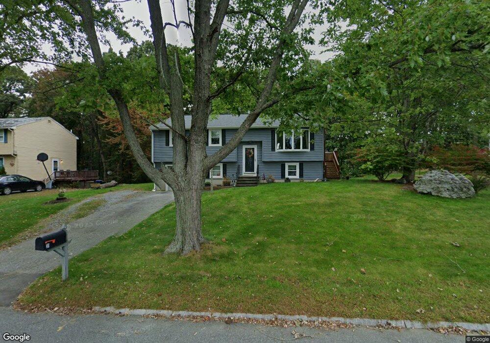
31 Jayson Rd Methuen, MA 01844
The East End NeighborhoodEstimated Value: $565,000 - $649,000
3
Beds
1
Bath
1,524
Sq Ft
$396/Sq Ft
Est. Value
About This Home
This home is located at 31 Jayson Rd, Methuen, MA 01844 and is currently estimated at $603,050, approximately $395 per square foot. 31 Jayson Rd is a home located in Essex County with nearby schools including Timony Grammar School, Methuen High School, and Community Day Charter Public School - Gateway.
Ownership History
Date
Name
Owned For
Owner Type
Purchase Details
Closed on
Mar 23, 2001
Sold by
31 Jayson Rd Rt
Bought by
Sanise Edward and Pierre Michelle A
Current Estimated Value
Purchase Details
Closed on
Aug 16, 1999
Sold by
Pouliot David A and Pouliot Lisa M
Bought by
Pouliot Steven E
Purchase Details
Closed on
Jun 28, 1996
Sold by
Slack James E
Bought by
Pouliot David A
Create a Home Valuation Report for This Property
The Home Valuation Report is an in-depth analysis detailing your home's value as well as a comparison with similar homes in the area
Home Values in the Area
Average Home Value in this Area
Purchase History
| Date | Buyer | Sale Price | Title Company |
|---|---|---|---|
| Sanise Edward | $222,000 | -- | |
| Sanise Edward | $222,000 | -- | |
| Pouliot Steven E | $180,000 | -- | |
| Pouliot Steven E | $180,000 | -- | |
| Pouliot David A | $133,500 | -- | |
| Pouliot David A | $133,500 | -- |
Source: Public Records
Mortgage History
| Date | Status | Borrower | Loan Amount |
|---|---|---|---|
| Open | Pouliot David A | $205,500 | |
| Closed | Pouliot David A | $205,000 |
Source: Public Records
Tax History
| Year | Tax Paid | Tax Assessment Tax Assessment Total Assessment is a certain percentage of the fair market value that is determined by local assessors to be the total taxable value of land and additions on the property. | Land | Improvement |
|---|---|---|---|---|
| 2025 | $5,194 | $490,900 | $208,500 | $282,400 |
| 2024 | $5,261 | $484,400 | $190,200 | $294,200 |
| 2023 | $4,958 | $423,800 | $169,000 | $254,800 |
| 2022 | $4,761 | $364,800 | $140,900 | $223,900 |
| 2021 | $4,514 | $342,200 | $133,800 | $208,400 |
| 2020 | $4,474 | $332,900 | $133,800 | $199,100 |
| 2019 | $4,301 | $303,100 | $119,700 | $183,400 |
| 2018 | $4,143 | $290,300 | $119,700 | $170,600 |
| 2017 | $3,970 | $271,000 | $119,700 | $151,300 |
| 2016 | $3,814 | $257,500 | $112,700 | $144,800 |
| 2015 | $3,713 | $254,300 | $112,700 | $141,600 |
Source: Public Records
Map
Nearby Homes
- 1 Riverview Blvd Unit 8-203
- 1 Riverview Blvd Unit 3-8
- 3 Thissell St
- 21 Oak St Unit A
- 68 Ashford St
- 18 Erhardt Terrace
- 264 E Haverhill St Unit 2
- 106 Leroy Ave
- 86 Comet Rd
- 60 Ames St
- 39 Swan Ave
- 30 Anderson Dr
- 2 Leslie St
- 80 Ferry St Unit 80A
- 144 Ferry St
- 5 Pilgrim Cir Unit C
- 35 Christopher Dr
- 27 Woodland Ct
- 0 Great Pond Rd
- 37 Albion St