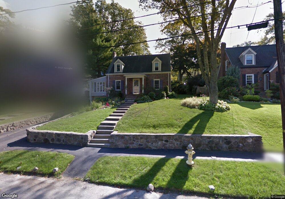
31 Laurel Dr Unit 31 Needham, MA 02492
Estimated Value: $1,219,000 - $1,413,000
3
Beds
2
Baths
1,854
Sq Ft
$711/Sq Ft
Est. Value
About This Home
This home is located at 31 Laurel Dr Unit 31, Needham, MA 02492 and is currently estimated at $1,318,436, approximately $711 per square foot. 31 Laurel Dr Unit 31 is a home located in Norfolk County with nearby schools including Newman Elementary School, High Rock Middle School, and Pollard Middle School.
Ownership History
Date
Name
Owned For
Owner Type
Purchase Details
Closed on
Oct 17, 2025
Sold by
Chen Tony and Chen Julianne
Bought by
J & P Laurel Llc
Current Estimated Value
Purchase Details
Closed on
Dec 2, 2022
Sold by
Nancy J Kubilus 2006 Ret and Kubilus
Bought by
Chen Tony and Chen Julianne
Home Financials for this Owner
Home Financials are based on the most recent Mortgage that was taken out on this home.
Original Mortgage
$715,000
Interest Rate
6.95%
Mortgage Type
Purchase Money Mortgage
Purchase Details
Closed on
Apr 18, 2017
Sold by
Kubilus Nancy
Bought by
Nancy J Kubilus 2006 R J and Nancy Kubilus
Purchase Details
Closed on
Jun 29, 2016
Sold by
Turnbaugh Lisa R
Bought by
Kubilus Nancy
Home Financials for this Owner
Home Financials are based on the most recent Mortgage that was taken out on this home.
Original Mortgage
$265,000
Interest Rate
3.58%
Mortgage Type
New Conventional
Purchase Details
Closed on
May 27, 1987
Sold by
Grover Doroth-Ann
Bought by
Henry Douglas M
Create a Home Valuation Report for This Property
The Home Valuation Report is an in-depth analysis detailing your home's value as well as a comparison with similar homes in the area
Home Values in the Area
Average Home Value in this Area
Purchase History
| Date | Buyer | Sale Price | Title Company |
|---|---|---|---|
| J & P Laurel Llc | $1,195,000 | -- | |
| Chen Tony | $1,175,000 | None Available | |
| Nancy J Kubilus 2006 R J | -- | -- | |
| Kubilus Nancy | $829,000 | -- | |
| Henry Douglas M | $209,900 | -- |
Source: Public Records
Mortgage History
| Date | Status | Borrower | Loan Amount |
|---|---|---|---|
| Previous Owner | Chen Tony | $715,000 | |
| Previous Owner | Kubilus Nancy | $265,000 | |
| Previous Owner | Henry Douglas M | $168,000 | |
| Previous Owner | Henry Douglas M | $258,600 | |
| Previous Owner | Henry Douglas M | $137,650 |
Source: Public Records
Tax History Compared to Growth
Tax History
| Year | Tax Paid | Tax Assessment Tax Assessment Total Assessment is a certain percentage of the fair market value that is determined by local assessors to be the total taxable value of land and additions on the property. | Land | Improvement |
|---|---|---|---|---|
| 2025 | $13,205 | $1,245,800 | $725,800 | $520,000 |
| 2024 | $13,811 | $1,103,100 | $508,300 | $594,800 |
| 2023 | $11,509 | $882,600 | $508,300 | $374,300 |
| 2022 | $11,151 | $834,000 | $470,600 | $363,400 |
| 2021 | $10,867 | $834,000 | $470,600 | $363,400 |
| 2020 | $10,440 | $835,900 | $472,600 | $363,300 |
| 2019 | $9,781 | $789,400 | $429,700 | $359,700 |
| 2018 | $9,322 | $784,700 | $429,700 | $355,000 |
| 2017 | $8,530 | $717,400 | $429,700 | $287,700 |
| 2016 | $7,890 | $683,700 | $429,700 | $254,000 |
| 2015 | $7,719 | $683,700 | $429,700 | $254,000 |
| 2014 | $7,432 | $638,500 | $390,600 | $247,900 |
Source: Public Records
Map
Nearby Homes
- 1011 Webster St
- 233 Warren St
- 317 Dedham Ave
- 47 Emerson Rd
- 120 Wildwood Dr
- 71 School St
- 30 Richardson Dr
- 154 Warren St
- 287 High Rock St
- 53 Heather Ln
- 828 South St
- 26 Pinewood Rd
- 42 Otis St Unit R
- 40 Otis St Unit L
- 98 Heather Ln
- 24 Deerfield Rd
- 957 South St
- 62 Washington Ave
- 178 South St
- 247 Broad Meadow Rd