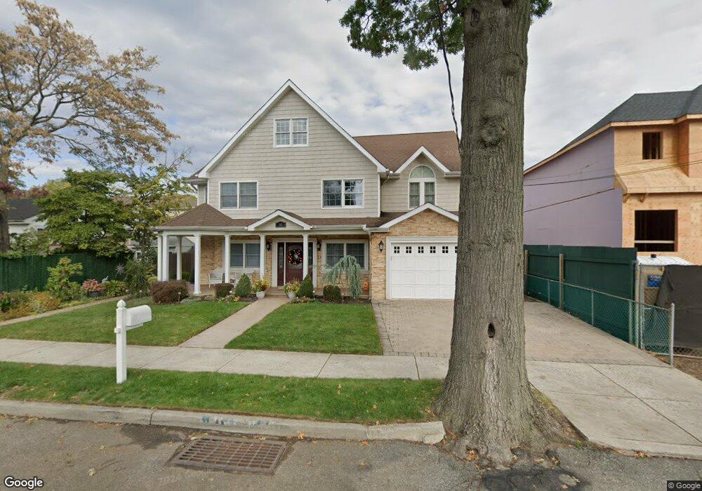
31 Sanford St Staten Island, NY 10307
Tottenville NeighborhoodEstimated Value: $916,000 - $1,083,000
6
Beds
3
Baths
2,150
Sq Ft
$455/Sq Ft
Est. Value
About This Home
This home is located at 31 Sanford St, Staten Island, NY 10307 and is currently estimated at $977,357, approximately $454 per square foot. 31 Sanford St is a home located in Richmond County with nearby schools including P.S. 6 Cpl Allan F Kivlehan School, Is 34 Tottenville, and Tottenville High School.
Ownership History
Date
Name
Owned For
Owner Type
Purchase Details
Closed on
Nov 3, 2023
Sold by
Cosgrove Thomas J and Cosgrove Caryn A
Bought by
Cosgrove Family Living Trust and Cosgrove
Current Estimated Value
Purchase Details
Closed on
Jul 19, 1999
Sold by
Galizia Frank V
Bought by
Cosgrove Thomas J and Cosgrove Caryn A
Home Financials for this Owner
Home Financials are based on the most recent Mortgage that was taken out on this home.
Original Mortgage
$185,000
Interest Rate
8.11%
Create a Home Valuation Report for This Property
The Home Valuation Report is an in-depth analysis detailing your home's value as well as a comparison with similar homes in the area
Home Values in the Area
Average Home Value in this Area
Purchase History
| Date | Buyer | Sale Price | Title Company |
|---|---|---|---|
| Cosgrove Family Living Trust | -- | Fidelity National Title | |
| Cosgrove Thomas J | $299,000 | -- |
Source: Public Records
Mortgage History
| Date | Status | Borrower | Loan Amount |
|---|---|---|---|
| Previous Owner | Cosgrove Thomas J | $185,000 |
Source: Public Records
Tax History Compared to Growth
Tax History
| Year | Tax Paid | Tax Assessment Tax Assessment Total Assessment is a certain percentage of the fair market value that is determined by local assessors to be the total taxable value of land and additions on the property. | Land | Improvement |
|---|---|---|---|---|
| 2025 | $8,821 | $46,140 | $17,762 | $28,378 |
| 2024 | $8,821 | $49,260 | $16,637 | $32,623 |
| 2023 | $8,853 | $43,591 | $15,819 | $27,772 |
| 2022 | $8,210 | $45,660 | $18,660 | $27,000 |
| 2021 | $8,165 | $42,420 | $18,660 | $23,760 |
| 2020 | $7,747 | $36,600 | $18,660 | $17,940 |
| 2019 | $8,071 | $38,580 | $18,660 | $19,920 |
| 2018 | $7,424 | $36,420 | $18,660 | $17,760 |
| 2017 | $7,803 | $38,280 | $18,660 | $19,620 |
| 2016 | $7,988 | $39,960 | $17,703 | $22,257 |
| 2015 | $7,067 | $38,460 | $15,540 | $22,920 |
| 2014 | $7,067 | $36,824 | $14,856 | $21,968 |
Source: Public Records
Map
Nearby Homes
- 25 Sanford St
- 37 Sprague Ave
- 35 Sprague Ave
- 41 Sprague Ave
- 25 Sprague Ave
- 17 Sanford St
- 17 Sanford St
- 53 Sprague Ave
- 53 Sprague Ave Unit Ph
- 24 Sanford St
- 22 Sanford St
- 20 Sanford St
- 18-20 Sanford St
- 18 Sanford St Unit 20
- 7262-7262E Amboy Rd Unit E1
- 7262D Amboy Rd
- 7262E Amboy Rd
- 17 Sprague Ave
- 16 Sanford St
- 7262A Amboy Rd