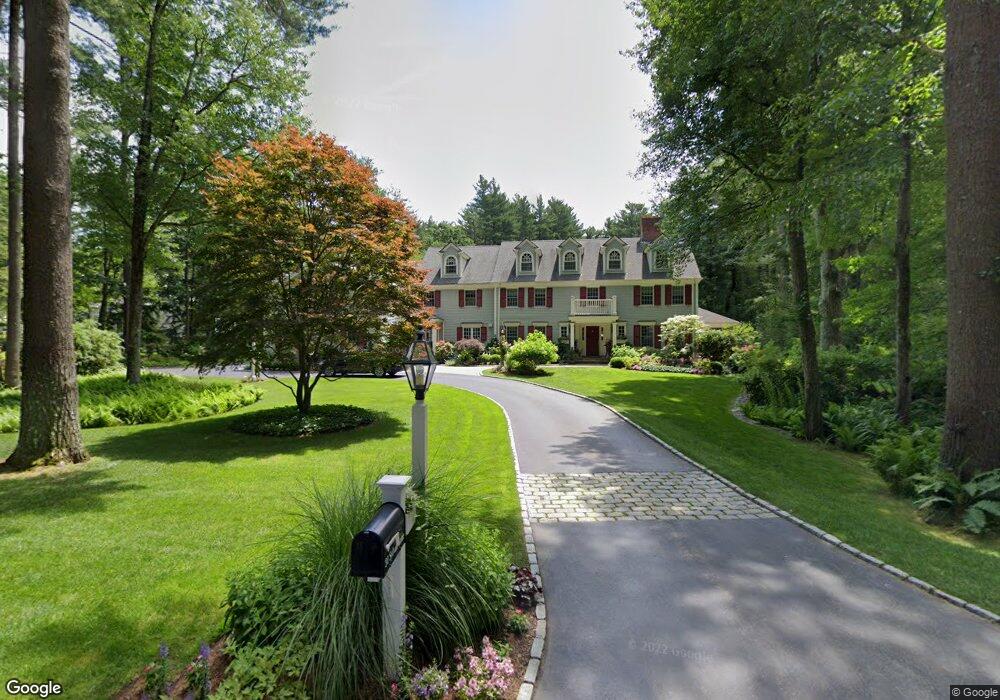
31 Sylvan Ln Weston, MA 02493
Estimated Value: $3,979,229 - $5,911,000
5
Beds
6
Baths
7,723
Sq Ft
$642/Sq Ft
Est. Value
About This Home
This home is located at 31 Sylvan Ln, Weston, MA 02493 and is currently estimated at $4,954,410, approximately $641 per square foot. 31 Sylvan Ln is a home located in Middlesex County with nearby schools including Country Elementary School, Woodland Elementary School, and Field Elementary School.
Ownership History
Date
Name
Owned For
Owner Type
Purchase Details
Closed on
Jun 3, 2003
Sold by
Maus Gerard and Maus Susan A
Bought by
Higgins Michael and Higgins Carla J
Current Estimated Value
Home Financials for this Owner
Home Financials are based on the most recent Mortgage that was taken out on this home.
Original Mortgage
$1,100,000
Outstanding Balance
$455,313
Interest Rate
5.86%
Mortgage Type
Purchase Money Mortgage
Estimated Equity
$4,499,097
Purchase Details
Closed on
Dec 15, 1998
Sold by
Bowhers Helen
Bought by
Maus Gerard and Maus Susan A
Home Financials for this Owner
Home Financials are based on the most recent Mortgage that was taken out on this home.
Original Mortgage
$648,750
Interest Rate
6.8%
Mortgage Type
Purchase Money Mortgage
Create a Home Valuation Report for This Property
The Home Valuation Report is an in-depth analysis detailing your home's value as well as a comparison with similar homes in the area
Home Values in the Area
Average Home Value in this Area
Purchase History
| Date | Buyer | Sale Price | Title Company |
|---|---|---|---|
| Higgins Michael | $2,100,000 | -- | |
| Higgins Michael | $2,100,000 | -- | |
| Maus Gerard | $865,000 | -- |
Source: Public Records
Mortgage History
| Date | Status | Borrower | Loan Amount |
|---|---|---|---|
| Open | Higgins Michael | $1,100,000 | |
| Closed | Maus Gerard | $1,100,000 | |
| Previous Owner | Maus Gerard | $648,750 |
Source: Public Records
Tax History
| Year | Tax Paid | Tax Assessment Tax Assessment Total Assessment is a certain percentage of the fair market value that is determined by local assessors to be the total taxable value of land and additions on the property. | Land | Improvement |
|---|---|---|---|---|
| 2025 | $39,435 | $3,552,700 | $1,060,300 | $2,492,400 |
| 2024 | $38,631 | $3,474,000 | $1,060,300 | $2,413,700 |
| 2023 | $38,235 | $3,229,300 | $1,060,300 | $2,169,000 |
| 2022 | $36,076 | $2,816,200 | $1,011,300 | $1,804,900 |
| 2021 | $477 | $2,687,400 | $963,900 | $1,723,500 |
| 2020 | $33,738 | $2,629,600 | $963,900 | $1,665,700 |
| 2019 | $32,962 | $2,618,100 | $963,900 | $1,654,200 |
| 2018 | $32,752 | $2,618,100 | $963,900 | $1,654,200 |
| 2017 | $515 | $2,637,300 | $963,900 | $1,673,400 |
| 2016 | $32,070 | $2,637,300 | $963,900 | $1,673,400 |
| 2015 | $31,498 | $2,565,000 | $918,300 | $1,646,700 |
Source: Public Records
Map
Nearby Homes
- 568 Wellesley St
- 556 Wellesley St
- 169 Hickory Rd
- 79 Walnut Rd
- 83 Brown St
- 120 Rockport Rd
- 15 Rockport Rd
- 6 Meadowbrook Rd
- 19 Northgate Rd
- 451 Wellesley St
- 53 Chesterton Rd
- 41 Chesterton Rd
- 172 Country Dr
- 6 Boulder Brook Rd
- 6 Briar Ln
- 16 Indian Dawn Unit 16
- 199 Country Dr
- 100 Westcliff Rd
- 48 Scotch Pine Rd
- 84 Royalston Rd
Your Personal Tour Guide
Ask me questions while you tour the home.