Estimated Value: $1,228,000 - $1,552,000
4
Beds
4
Baths
2,304
Sq Ft
$614/Sq Ft
Est. Value
About This Home
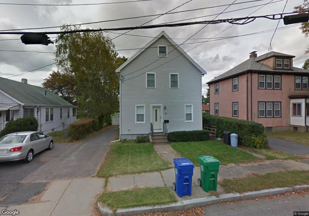
This home is located at 31 Wade St, Newton Highlands, MA 02461 and is currently estimated at $1,413,698, approximately $613 per square foot. 31 Wade St is a home located in Middlesex County with nearby schools including Countryside Elementary School, Charles E Brown Middle School, and Newton South High School.
Ownership History
Date
Name
Owned For
Owner Type
Purchase Details
Closed on
Jan 16, 2020
Sold by
31 Wade Street Rt
Bought by
Moy Kevin and Moy Winnie
Current Estimated Value
Home Financials for this Owner
Home Financials are based on the most recent Mortgage that was taken out on this home.
Original Mortgage
$501,000
Outstanding Balance
$441,625
Interest Rate
3.7%
Mortgage Type
New Conventional
Estimated Equity
$972,073
Purchase Details
Closed on
Jul 16, 2019
Sold by
Moy Kevin and Moy Winnie
Bought by
34 Wade Street Rt
Purchase Details
Closed on
Nov 25, 1997
Sold by
Lui Kenneth K and Lee Bianca S
Bought by
Moy Kevin and Moy Winnie
Purchase Details
Closed on
Jan 18, 1995
Sold by
Chan Chi Hang and Chan Mona L
Bought by
Lui Kenneth K and Lui Bianca S
Purchase Details
Closed on
Sep 18, 1987
Sold by
Macdonald Sumileo
Bought by
Chan Chi Hang
Create a Home Valuation Report for This Property
The Home Valuation Report is an in-depth analysis detailing your home's value as well as a comparison with similar homes in the area
Home Values in the Area
Average Home Value in this Area
Purchase History
| Date | Buyer | Sale Price | Title Company |
|---|---|---|---|
| Moy Kevin | -- | None Available | |
| 34 Wade Street Rt | -- | -- | |
| Moy Kevin | $200,000 | -- | |
| Lui Kenneth K | $155,000 | -- | |
| Chan Chi Hang | $139,900 | -- |
Source: Public Records
Mortgage History
| Date | Status | Borrower | Loan Amount |
|---|---|---|---|
| Open | Moy Kevin | $501,000 | |
| Previous Owner | Chan Chi Hang | $325,000 | |
| Previous Owner | Chan Chi Hang | $25,000 |
Source: Public Records
Tax History Compared to Growth
Tax History
| Year | Tax Paid | Tax Assessment Tax Assessment Total Assessment is a certain percentage of the fair market value that is determined by local assessors to be the total taxable value of land and additions on the property. | Land | Improvement |
|---|---|---|---|---|
| 2025 | $9,162 | $934,900 | $762,800 | $172,100 |
| 2024 | $8,859 | $907,700 | $740,600 | $167,100 |
| 2023 | $8,430 | $828,100 | $557,800 | $270,300 |
| 2022 | $8,067 | $766,800 | $516,500 | $250,300 |
| 2021 | $7,784 | $723,400 | $487,300 | $236,100 |
| 2020 | $7,552 | $723,400 | $487,300 | $236,100 |
| 2019 | $7,339 | $702,300 | $473,100 | $229,200 |
| 2018 | $7,030 | $649,700 | $430,300 | $219,400 |
| 2017 | $6,815 | $612,900 | $405,900 | $207,000 |
| 2016 | $6,518 | $572,800 | $379,300 | $193,500 |
| 2015 | $6,215 | $535,300 | $354,500 | $180,800 |
Source: Public Records
Map
Nearby Homes
- 1292 Walnut St
- 1308 Walnut St
- 1629 Centre St
- 1623-1625 Centre St
- 1597 Centre St Unit 1597
- 1597 Centre St
- 116 Upland Ave
- 1151 Walnut St Unit 205
- 1151 Walnut St Unit 405
- 1151 Walnut St Unit 207
- 125 Oakdale Rd
- 3 Glenmore Terrace Unit 2
- 671 Boylston St
- 250 Woodcliff Rd
- 200 Lincoln St
- 2 Raeburn Terrace
- 36 Cannon St
- 19 Selwyn Rd
- 628 Boylston St
- 42 Sunhill Ln