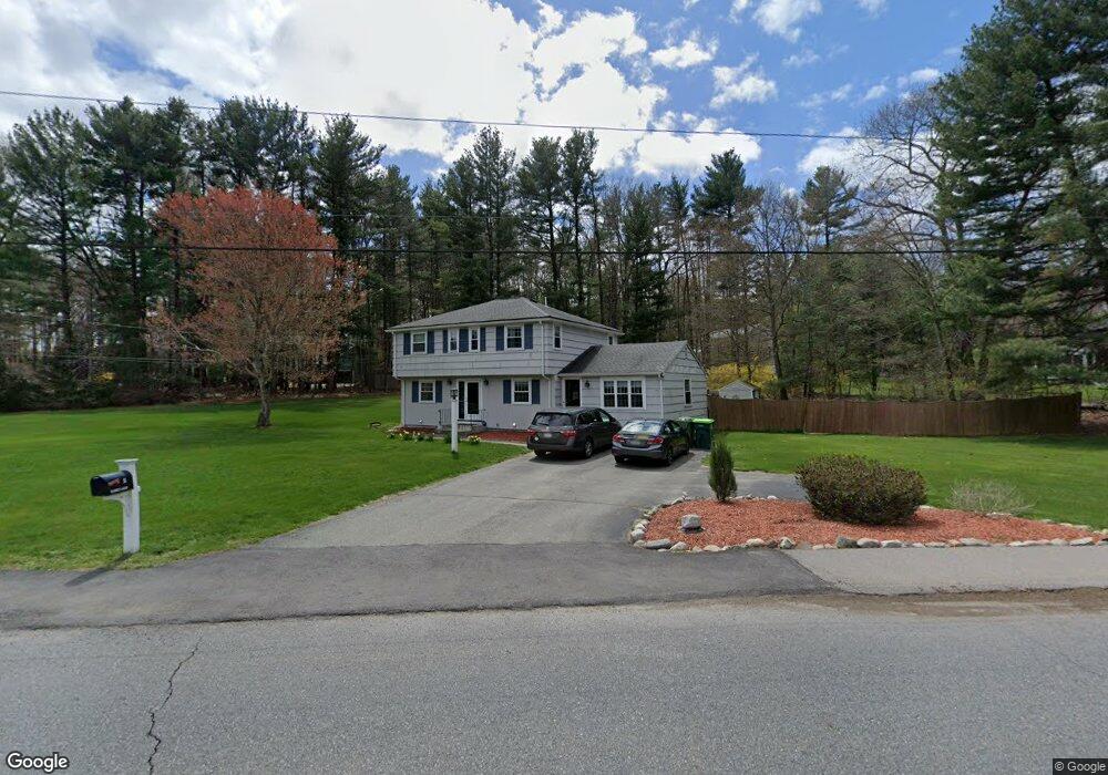
31 Warren Rd Sudbury, MA 01776
Estimated Value: $882,155 - $1,023,000
4
Beds
2
Baths
1,958
Sq Ft
$475/Sq Ft
Est. Value
About This Home
This home is located at 31 Warren Rd, Sudbury, MA 01776 and is currently estimated at $929,539, approximately $474 per square foot. 31 Warren Rd is a home located in Middlesex County with nearby schools including Israel Loring Elementary School, Ephraim Curtis Middle School, and Lincoln-Sudbury Regional High School.
Ownership History
Date
Name
Owned For
Owner Type
Purchase Details
Closed on
Oct 14, 2011
Sold by
Smith Jane W and Smith William Jb
Bought by
Bloom Andrew J and Bloom Lydia
Current Estimated Value
Home Financials for this Owner
Home Financials are based on the most recent Mortgage that was taken out on this home.
Original Mortgage
$336,000
Outstanding Balance
$230,816
Interest Rate
4.25%
Mortgage Type
Purchase Money Mortgage
Estimated Equity
$698,723
Purchase Details
Closed on
Sep 2, 2003
Sold by
Anderson Marion L and Anderson Paul G
Bought by
Smith Jane W and Smith William J
Home Financials for this Owner
Home Financials are based on the most recent Mortgage that was taken out on this home.
Original Mortgage
$391,920
Interest Rate
5.69%
Mortgage Type
Purchase Money Mortgage
Create a Home Valuation Report for This Property
The Home Valuation Report is an in-depth analysis detailing your home's value as well as a comparison with similar homes in the area
Home Values in the Area
Average Home Value in this Area
Purchase History
| Date | Buyer | Sale Price | Title Company |
|---|---|---|---|
| Bloom Andrew J | $436,000 | -- | |
| Bloom Andrew J | $436,000 | -- | |
| Smith Jane W | $489,900 | -- | |
| Smith Jane W | $489,900 | -- |
Source: Public Records
Mortgage History
| Date | Status | Borrower | Loan Amount |
|---|---|---|---|
| Open | Bloom Andrew J | $336,000 | |
| Closed | Smith Jane W | $336,000 | |
| Previous Owner | Smith Jane W | $391,920 |
Source: Public Records
Tax History Compared to Growth
Tax History
| Year | Tax Paid | Tax Assessment Tax Assessment Total Assessment is a certain percentage of the fair market value that is determined by local assessors to be the total taxable value of land and additions on the property. | Land | Improvement |
|---|---|---|---|---|
| 2025 | $11,194 | $764,600 | $439,200 | $325,400 |
| 2024 | $10,800 | $739,200 | $426,400 | $312,800 |
| 2023 | $10,359 | $656,900 | $394,800 | $262,100 |
| 2022 | $10,224 | $566,400 | $362,400 | $204,000 |
| 2021 | $10,057 | $534,100 | $362,400 | $171,700 |
| 2020 | $9,854 | $534,100 | $362,400 | $171,700 |
| 2019 | $9,566 | $534,100 | $362,400 | $171,700 |
| 2018 | $9,743 | $543,400 | $386,400 | $157,000 |
| 2017 | $9,280 | $523,100 | $367,600 | $155,500 |
| 2016 | $8,984 | $504,700 | $353,600 | $151,100 |
| 2015 | $8,293 | $471,200 | $323,000 | $148,200 |
| 2014 | $8,270 | $458,700 | $313,500 | $145,200 |
Source: Public Records
Map
Nearby Homes
- 84 Hopestill Brown Rd
- 0 Wagonwheel Rd
- 63 Landham Rd
- 14 Eisenhower Rd
- 216 Landham Rd
- 91 Eaton Rd W
- 19 Nob Hill Dr
- 32 Eaton Rd W
- 128 Nobscot Rd
- 1011 Boston Post Rd
- 27 Sloane Dr
- 23 Massasoit Ave
- 30 Edith Rd
- 30 Nobscot Rd Unit 14
- 36 Concord Rd
- 14 Francine Rd
- 24 Woodland Rd
- 41 James St
- 8 Clara Rd
- 40 Gregory Rd