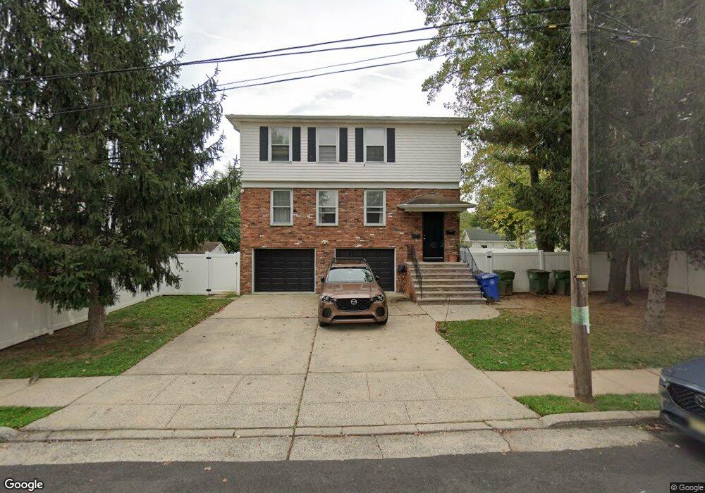
310 4th Ave Linden, NJ 07036
Estimated Value: $611,000 - $792,000
3
Beds
1
Bath
1,584
Sq Ft
$427/Sq Ft
Est. Value
About This Home
This home is located at 310 4th Ave, Linden, NJ 07036 and is currently estimated at $675,969, approximately $426 per square foot. 310 4th Ave is a home located in Union County with nearby schools including Number 1, Joseph E. Soehl Middle School, and Linden High School.
Ownership History
Date
Name
Owned For
Owner Type
Purchase Details
Closed on
Oct 13, 2015
Sold by
New Jersey Housing & Mortgage Finan
Bought by
Collado Jose A
Current Estimated Value
Purchase Details
Closed on
Jun 4, 2014
Sold by
Froehlich Ralph
Bought by
Mcclary Ii Carlton
Purchase Details
Closed on
Nov 4, 1999
Sold by
Reavis Raymond
Bought by
Mcclary Ii Carlton and Mcclary Doris
Home Financials for this Owner
Home Financials are based on the most recent Mortgage that was taken out on this home.
Original Mortgage
$225,000
Interest Rate
7.68%
Create a Home Valuation Report for This Property
The Home Valuation Report is an in-depth analysis detailing your home's value as well as a comparison with similar homes in the area
Home Values in the Area
Average Home Value in this Area
Purchase History
| Date | Buyer | Sale Price | Title Company |
|---|---|---|---|
| Collado Jose A | $310,000 | -- | |
| Mcclary Ii Carlton | $1,000 | None Available | |
| Mcclary Ii Carlton | $257,500 | -- |
Source: Public Records
Mortgage History
| Date | Status | Borrower | Loan Amount |
|---|---|---|---|
| Previous Owner | Mcclary Ii Carlton | $225,000 |
Source: Public Records
Tax History
| Year | Tax Paid | Tax Assessment Tax Assessment Total Assessment is a certain percentage of the fair market value that is determined by local assessors to be the total taxable value of land and additions on the property. | Land | Improvement |
|---|---|---|---|---|
| 2025 | $12,018 | $170,900 | $60,000 | $110,900 |
| 2024 | $11,755 | $170,900 | $60,000 | $110,900 |
| 2023 | $11,755 | $170,900 | $60,000 | $110,900 |
| 2022 | $11,816 | $170,900 | $60,000 | $110,900 |
| 2021 | $11,876 | $170,900 | $60,000 | $110,900 |
| 2020 | $11,813 | $170,900 | $60,000 | $110,900 |
| 2019 | $11,773 | $170,900 | $60,000 | $110,900 |
| 2018 | $11,770 | $170,900 | $60,000 | $110,900 |
| 2017 | $11,515 | $170,900 | $60,000 | $110,900 |
| 2016 | $11,153 | $170,900 | $60,000 | $110,900 |
| 2015 | $12,673 | $170,900 | $60,000 | $110,900 |
| 2014 | $12,673 | $205,900 | $60,000 | $145,900 |
Source: Public Records
Map
Nearby Homes
- 812 Washington Ave
- 909 Seymour Ave
- 113 E Curtis St
- 725 N Wood Ave
- 215 Victory St
- 574 Sherman Ave
- 142 Bonna Villa Ave
- 721 E Curtis St
- 1210 Orchard Terrace
- 400 Douglas Rd
- 811 Jackson Ave
- 918 Bower St
- 914 Bower St
- 3 Fern St
- 382 Douglas Rd
- 534 Monmouth Ave
- 1709 Wood Ave Unit A1
- 609 Harrison Place
- 925 Summit St
- 830 E Curtis St
- 1012 Wheatsheaf Rd
- 1014 Wheatsheaf Rd Unit 1016
- 1017 Walnut St
- 1015 Walnut St
- 1008 Wheatsheaf Rd
- 313 3rd Ave Unit 2
- 313 3rd Ave
- 1011 Walnut St
- 1009 Walnut St
- 1006 Wheatsheaf Rd
- 1101 Walnut St
- 1007 Walnut St
- 307 4th Ave
- 1103 Walnut St
- 1000 Wheatsheaf Rd
- 1001 Walnut St
- 1105 Walnut St
- 1100 Wheatsheaf Rd
- 1107 Walnut St
- 1108 Wheatsheaf Rd
Your Personal Tour Guide
Ask me questions while you tour the home.