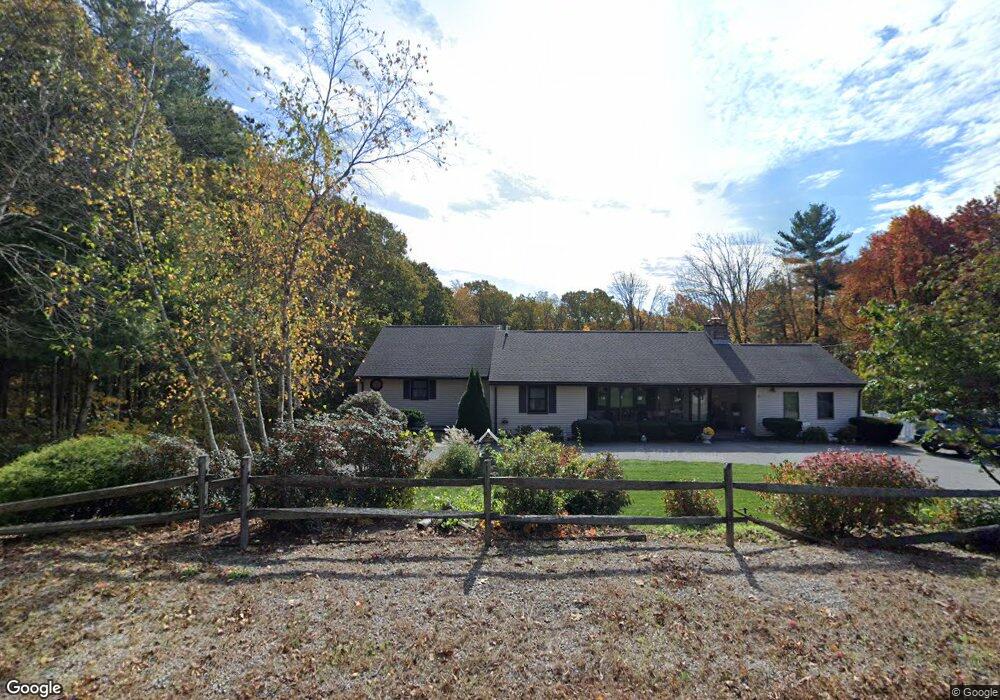
310 Aldrich St Uxbridge, MA 01569
Estimated Value: $660,521 - $704,000
3
Beds
2
Baths
2,344
Sq Ft
$289/Sq Ft
Est. Value
About This Home
This home is located at 310 Aldrich St, Uxbridge, MA 01569 and is currently estimated at $677,880, approximately $289 per square foot. 310 Aldrich St is a home located in Worcester County with nearby schools including Uxbridge High School and Our Lady of the Valley Regional School.
Ownership History
Date
Name
Owned For
Owner Type
Purchase Details
Closed on
Oct 10, 2017
Sold by
Maloney Edward L
Bought by
Gomes Ricky M and Gomes Donna M
Current Estimated Value
Home Financials for this Owner
Home Financials are based on the most recent Mortgage that was taken out on this home.
Original Mortgage
$276,000
Outstanding Balance
$230,785
Interest Rate
3.86%
Mortgage Type
New Conventional
Estimated Equity
$447,095
Purchase Details
Closed on
Apr 8, 2016
Sold by
Maloney Mary B
Bought by
Maloney Edward L
Purchase Details
Closed on
Nov 22, 2011
Sold by
Peckham Robert K and Peckham Sandra D
Bought by
Maloney Mary B
Home Financials for this Owner
Home Financials are based on the most recent Mortgage that was taken out on this home.
Original Mortgage
$285,572
Interest Rate
4.4%
Mortgage Type
FHA
Create a Home Valuation Report for This Property
The Home Valuation Report is an in-depth analysis detailing your home's value as well as a comparison with similar homes in the area
Home Values in the Area
Average Home Value in this Area
Purchase History
| Date | Buyer | Sale Price | Title Company |
|---|---|---|---|
| Gomes Ricky M | $345,000 | -- | |
| Maloney Edward L | -- | -- | |
| Maloney Mary B | $293,000 | -- |
Source: Public Records
Mortgage History
| Date | Status | Borrower | Loan Amount |
|---|---|---|---|
| Open | Gomes Ricky M | $276,000 | |
| Previous Owner | Maloney Mary B | $285,572 |
Source: Public Records
Tax History Compared to Growth
Tax History
| Year | Tax Paid | Tax Assessment Tax Assessment Total Assessment is a certain percentage of the fair market value that is determined by local assessors to be the total taxable value of land and additions on the property. | Land | Improvement |
|---|---|---|---|---|
| 2025 | $68 | $518,400 | $173,400 | $345,000 |
| 2024 | $6,190 | $479,100 | $164,700 | $314,400 |
| 2023 | $5,643 | $404,500 | $142,200 | $262,300 |
| 2022 | $5,452 | $359,600 | $124,800 | $234,800 |
| 2021 | $5,648 | $357,000 | $122,200 | $234,800 |
| 2020 | $5,670 | $338,700 | $120,400 | $218,300 |
| 2019 | $5,802 | $334,400 | $120,400 | $214,000 |
| 2018 | $5,417 | $315,500 | $120,400 | $195,100 |
| 2017 | $5,410 | $319,000 | $110,600 | $208,400 |
| 2016 | $5,875 | $334,400 | $105,400 | $229,000 |
| 2015 | $5,749 | $330,400 | $105,400 | $225,000 |
Source: Public Records
Map
Nearby Homes
- 64 Acorn Dr
- 342 Chestnut St
- 98 Mantell Rd
- 503 Elmwood Ave
- 29 Glendale St
- 12 Turner Farm Rd
- 18 Turner Farm Rd
- 70 Chocolog Rd
- 46 Turner Farm Rd
- 127 Turner Farm Rd
- 117 Turner Farm Rd
- 657 Aldrich St
- 9 Balm of Life Spring Rd
- 106 Mantell Rd
- 97 Mantell Rd
- 88 Mantell Rd
- 127 Old Millville Rd
- 385 River Rd
- 323 Mount Pleasant Rd
- 10 Old Millville Rd