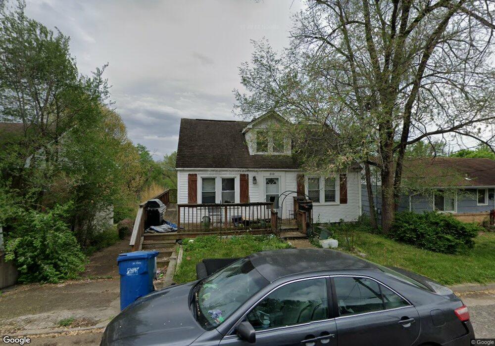
310 Buchanan St Jefferson City, MO 65101
Estimated Value: $145,000 - $164,000
2
Beds
1
Bath
1,008
Sq Ft
$153/Sq Ft
Est. Value
About This Home
This home is located at 310 Buchanan St, Jefferson City, MO 65101 and is currently estimated at $153,884, approximately $152 per square foot. 310 Buchanan St is a home located in Cole County with nearby schools including East Elementary School, Lewis & Clark Middle School, and Jefferson City High School.
Ownership History
Date
Name
Owned For
Owner Type
Purchase Details
Closed on
Oct 5, 2018
Sold by
Cain Robert and Cain Nanette
Bought by
Hagenhoff Shawn A
Current Estimated Value
Home Financials for this Owner
Home Financials are based on the most recent Mortgage that was taken out on this home.
Original Mortgage
$69,000
Outstanding Balance
$60,172
Interest Rate
4.5%
Mortgage Type
New Conventional
Estimated Equity
$93,712
Create a Home Valuation Report for This Property
The Home Valuation Report is an in-depth analysis detailing your home's value as well as a comparison with similar homes in the area
Home Values in the Area
Average Home Value in this Area
Purchase History
| Date | Buyer | Sale Price | Title Company |
|---|---|---|---|
| Hagenhoff Shawn A | -- | -- |
Source: Public Records
Mortgage History
| Date | Status | Borrower | Loan Amount |
|---|---|---|---|
| Open | Hagenhoff Shawn A | $69,000 |
Source: Public Records
Tax History Compared to Growth
Tax History
| Year | Tax Paid | Tax Assessment Tax Assessment Total Assessment is a certain percentage of the fair market value that is determined by local assessors to be the total taxable value of land and additions on the property. | Land | Improvement |
|---|---|---|---|---|
| 2025 | $648 | $10,860 | $1,330 | $9,530 |
| 2024 | $648 | $10,860 | $1,330 | $9,530 |
| 2023 | $648 | $10,860 | $1,330 | $9,530 |
| 2022 | $617 | $10,320 | $0 | $10,320 |
| 2021 | $621 | $10,320 | $0 | $10,320 |
| 2020 | $628 | $13,300 | $1,330 | $11,970 |
| 2019 | $611 | $12,122 | $1,330 | $10,792 |
| 2018 | $610 | $10,792 | $1,330 | $9,462 |
| 2017 | $596 | $10,317 | $1,330 | $8,987 |
| 2016 | $508 | $10,317 | $1,330 | $8,987 |
| 2015 | $509 | $0 | $0 | $0 |
| 2014 | $509 | $10,317 | $1,330 | $8,987 |
Source: Public Records
Map
Nearby Homes
- 201 Buchanan St
- 1326 Riverside Dr
- 108 N Taylor St
- 1404 Willcoxon Dr
- 105 Nash Ct
- 1403 E Mccarty St
- 1419 E Miller St
- 1422 E Miller St
- 1104 E High St
- 1119 E Mccarty St
- 217 Capitol Ct Unit A-C
- 306 Locust St
- 1219 Cottage Ln
- 218 Chris Dr
- 1233 E Dunklin St Unit A&B
- 224 Joe Ln
- 0 Highway 50
- 225 Joe Ln
- 0 Eastland Dr
- 228 Ann Ct
- 308 Buchanan St
- 312 Buchanan St
- 306 Buchanan St
- 314 Buchanan St
- 311 N Lincoln St
- 304 Buchanan St
- 309 N Lincoln St
- 311 Buchanan St
- 307 N Lincoln St
- 309 Buchanan St
- 313 Buchanan St
- 305 N Lincoln St
- 305 Buchanan St
- 302 Buchanan St
- 303 N Lincoln St
- 303 Buchanan St
- 301 N Lincoln St
- 301 Buchanan St
- 310 Pierce St
- 306 N Lincoln St