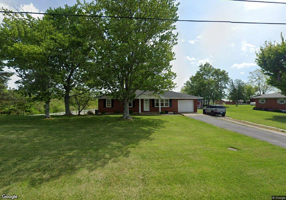
310 Davis Rd Campbellsville, KY 42718
Estimated Value: $174,000 - $206,000
3
Beds
1
Bath
1,300
Sq Ft
$147/Sq Ft
Est. Value
About This Home
This home is located at 310 Davis Rd, Campbellsville, KY 42718 and is currently estimated at $190,579, approximately $146 per square foot. 310 Davis Rd is a home located in Taylor County with nearby schools including Taylor County Elementary School, Taylor County Middle School, and Taylor County High School.
Ownership History
Date
Name
Owned For
Owner Type
Purchase Details
Closed on
Feb 17, 2021
Sold by
Ewing Joseph Brooks and Ewing Whitney
Bought by
Brawner James R
Current Estimated Value
Home Financials for this Owner
Home Financials are based on the most recent Mortgage that was taken out on this home.
Original Mortgage
$138,446
Outstanding Balance
$123,433
Interest Rate
2.65%
Mortgage Type
FHA
Estimated Equity
$67,146
Purchase Details
Closed on
Jul 14, 2015
Sold by
Ewing Joseph C
Bought by
Ewing Joseph Brooks and Ewing Whitney
Home Financials for this Owner
Home Financials are based on the most recent Mortgage that was taken out on this home.
Original Mortgage
$68,822
Interest Rate
3.92%
Mortgage Type
Purchase Money Mortgage
Purchase Details
Closed on
Oct 21, 2011
Sold by
Harvey Judy Tennyson and Tennyson Judy
Bought by
Harvey Carey Allen
Create a Home Valuation Report for This Property
The Home Valuation Report is an in-depth analysis detailing your home's value as well as a comparison with similar homes in the area
Home Values in the Area
Average Home Value in this Area
Purchase History
| Date | Buyer | Sale Price | Title Company |
|---|---|---|---|
| Brawner James R | $141,000 | Bluegrass Land Title Llc | |
| Ewing Joseph Brooks | $86,000 | None Available | |
| Harvey Carey Allen | $79,000 | None Available |
Source: Public Records
Mortgage History
| Date | Status | Borrower | Loan Amount |
|---|---|---|---|
| Open | Brawner James R | $138,446 | |
| Closed | Brawner James R | $6,000 | |
| Previous Owner | Ewing Joseph Brooks | $68,822 |
Source: Public Records
Tax History Compared to Growth
Tax History
| Year | Tax Paid | Tax Assessment Tax Assessment Total Assessment is a certain percentage of the fair market value that is determined by local assessors to be the total taxable value of land and additions on the property. | Land | Improvement |
|---|---|---|---|---|
| 2025 | $1,366 | $141,000 | $0 | $0 |
| 2024 | $1,384 | $141,000 | $0 | $0 |
| 2023 | $1,433 | $141,000 | $0 | $0 |
| 2022 | $1,456 | $141,000 | $0 | $0 |
| 2021 | $1,450 | $141,000 | $0 | $0 |
| 2020 | $904 | $86,000 | $0 | $0 |
| 2019 | $906 | $86,000 | $0 | $0 |
| 2018 | $890 | $86,000 | $0 | $0 |
| 2017 | $871 | $86,000 | $0 | $0 |
| 2016 | $850 | $86,000 | $0 | $0 |
| 2015 | $777 | $79,000 | $0 | $0 |
| 2014 | $760 | $79,000 | $0 | $0 |
| 2012 | -- | $79,000 | $0 | $0 |
Source: Public Records
Map
Nearby Homes
- 173 Natures Way
- 354 Wildwood Way
- 139 Sassy Ct
- 147 Sassy Ct
- 0 Greenleaf Dr
- 453 Greenleaf Dr
- 1780 Shiloh Rd
- 1281 Meadow Creek Rd
- 648 W Main St
- 1850 New Columbia Rd
- 10.37 m/l ac. W Blue Hole Rd Unit KY Hwy. 55 & Ky Hwy.
- 0 Plantation Dr
- 00 New Columbia Rd Unit Lot 2 (2.669 ac.)
- 0 New Columbia Rd Unit HK25004781
- 0 W Blue Hole Rd Unit 11536410
- 110 Garnett St
- 1.97 Akridge Rd
- 104 Popes Creek Dr
- 311 Summit Dr
- 151 Blue Hole Rd