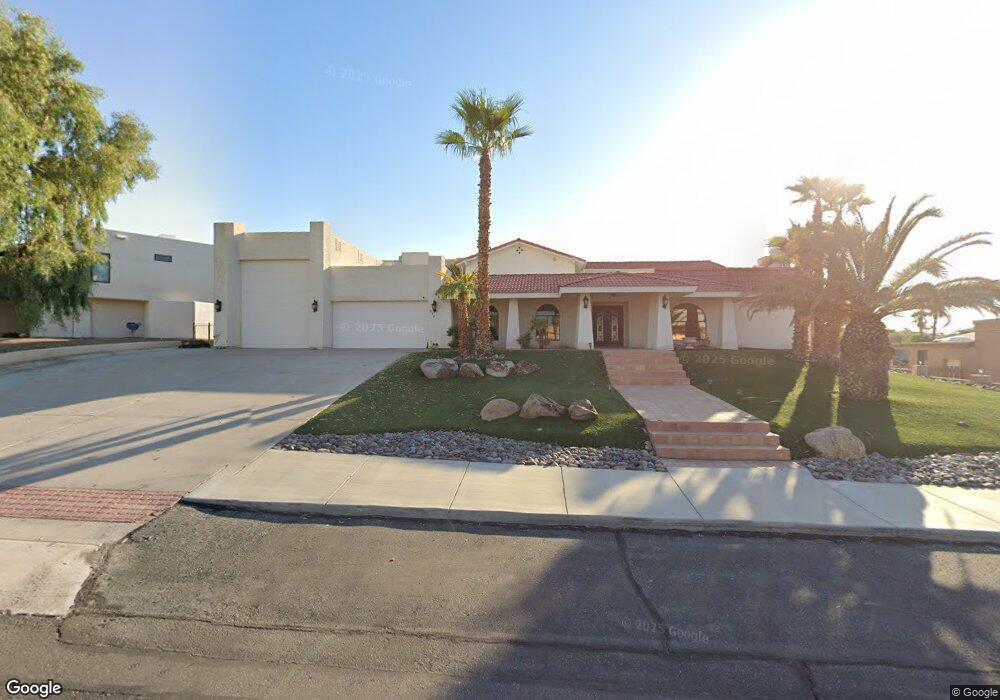
310 Jones Dr Lake Havasu City, AZ 86406
Estimated Value: $2,111,114 - $2,700,000
4
Beds
6
Baths
7,434
Sq Ft
$315/Sq Ft
Est. Value
About This Home
This home is located at 310 Jones Dr, Lake Havasu City, AZ 86406 and is currently estimated at $2,343,705, approximately $315 per square foot. 310 Jones Dr is a home located in Mohave County with nearby schools including Starline Elementary School, Thunderbolt Middle School, and Lake Havasu High School.
Ownership History
Date
Name
Owned For
Owner Type
Purchase Details
Closed on
Mar 22, 2018
Sold by
Betor Mark Allen and Mark Allen Betor Revocable Tru
Bought by
Lietz Kristen L and Kristen L Lietz Family Trust
Current Estimated Value
Home Financials for this Owner
Home Financials are based on the most recent Mortgage that was taken out on this home.
Original Mortgage
$600,000
Outstanding Balance
$514,152
Interest Rate
4.38%
Mortgage Type
Seller Take Back
Estimated Equity
$1,829,553
Purchase Details
Closed on
Nov 1, 2001
Sold by
Reach Harold and Reach Leda I
Bought by
Ybarra Joseph P and Ybarra Helen P
Home Financials for this Owner
Home Financials are based on the most recent Mortgage that was taken out on this home.
Original Mortgage
$206,667
Interest Rate
6.73%
Mortgage Type
Seller Take Back
Create a Home Valuation Report for This Property
The Home Valuation Report is an in-depth analysis detailing your home's value as well as a comparison with similar homes in the area
Home Values in the Area
Average Home Value in this Area
Purchase History
| Date | Buyer | Sale Price | Title Company |
|---|---|---|---|
| Lietz Kristen L | $600,000 | Pioneer Title Agency | |
| Ybarra Joseph P | $310,000 | Capital Title Agency Inc |
Source: Public Records
Mortgage History
| Date | Status | Borrower | Loan Amount |
|---|---|---|---|
| Open | Lietz Kristen L | $600,000 | |
| Previous Owner | Ybarra Joseph P | $206,667 |
Source: Public Records
Tax History Compared to Growth
Tax History
| Year | Tax Paid | Tax Assessment Tax Assessment Total Assessment is a certain percentage of the fair market value that is determined by local assessors to be the total taxable value of land and additions on the property. | Land | Improvement |
|---|---|---|---|---|
| 2026 | $7,129 | -- | -- | -- |
| 2025 | $7,233 | $159,123 | $0 | $0 |
| 2024 | $7,233 | $163,890 | $0 | $0 |
| 2023 | $7,233 | $152,250 | $0 | $0 |
| 2022 | $6,896 | $118,884 | $0 | $0 |
| 2021 | $7,200 | $99,384 | $0 | $0 |
| 2019 | $6,787 | $87,933 | $0 | $0 |
| 2018 | $6,521 | $83,806 | $0 | $0 |
| 2017 | $6,447 | $84,387 | $0 | $0 |
| 2016 | $5,740 | $84,729 | $0 | $0 |
| 2015 | $5,454 | $82,565 | $0 | $0 |
Source: Public Records
Map
Nearby Homes
- 2175 Snead Dr Unit 4
- 2175 Snead Dr Unit 6
- 2180 Snead Dr
- 2190 Snead Dr
- 2207 Oliver Ln
- 393 Hagen Way
- 209 Snead Dr
- 2041 Oak Dr
- 2371 Stroke Dr
- 2139 Palmer Dr
- 475 Jones Dr
- 2175 Palmer Dr
- 2224 Littler Ln Unit 28
- 2224 Littler Ln Unit 26
- 2288 Casper Ln
- 2295 Daytona Loop
- 2190 Palmer Dr
- 220 White Oak Dr
- 2280 Leonard Ln
- 2405 Wood Ln
- 320 Jones Dr
- 331 Jones Dr
- 290 Jones Dr
- 321 Jones Dr
- 330 Jones Dr
- 311 Jones Dr
- 301 Jones Dr
- 280 Jones Dr
- 345 Jones Dr
- 2170 Chip Dr
- 2170 Chip Dr
- 2170 Chip Dr
- 2175 A2 Snead Dr
- 2175 B8 Snead Dr
- 2150 Chip Dr
- 2175 Snead Dr Unit 2
- 2175 Snead Dr Unit B7
- 2175 Snead Dr Unit A5
- 2175 Snead Dr Unit 3
- 2175 Snead Dr