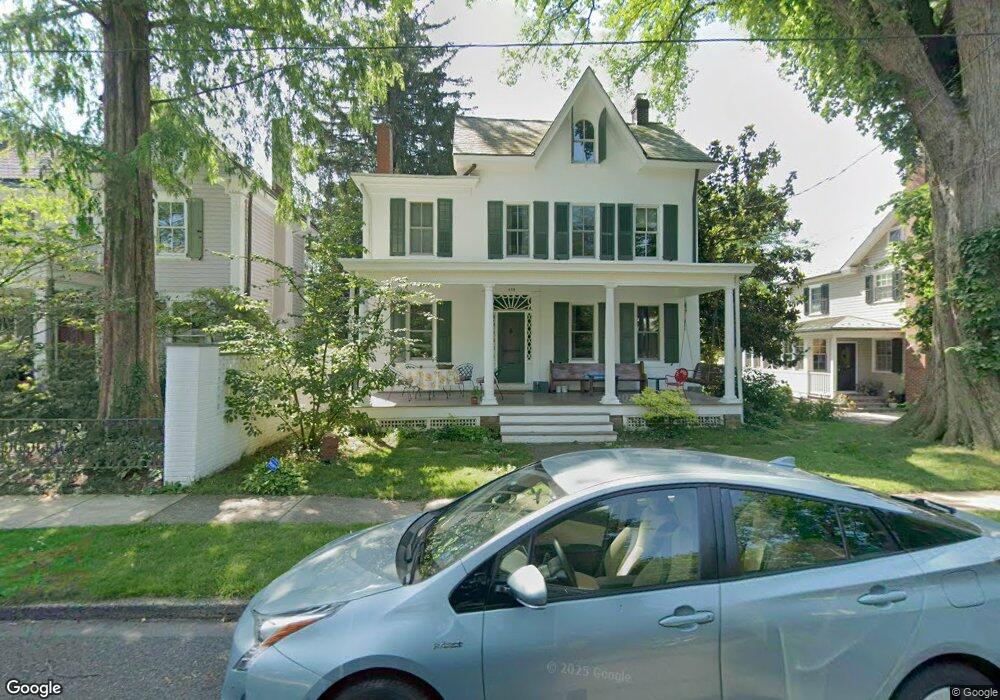
310 Maple Ave Doylestown, PA 18901
Estimated Value: $922,969 - $1,215,000
4
Beds
3
Baths
2,374
Sq Ft
$478/Sq Ft
Est. Value
About This Home
This home is located at 310 Maple Ave, Doylestown, PA 18901 and is currently estimated at $1,134,992, approximately $478 per square foot. 310 Maple Ave is a home located in Bucks County with nearby schools including Linden El School, Lenape Middle School, and Central Bucks High School-West.
Ownership History
Date
Name
Owned For
Owner Type
Purchase Details
Closed on
Oct 29, 2002
Sold by
Retseck George M and Retseck Pamela Anne
Bought by
Bowe Michael D and Bowe Caryn L
Current Estimated Value
Home Financials for this Owner
Home Financials are based on the most recent Mortgage that was taken out on this home.
Original Mortgage
$400,000
Outstanding Balance
$167,665
Interest Rate
6.03%
Estimated Equity
$967,327
Purchase Details
Closed on
Oct 16, 1995
Sold by
Stryker Ernestine A
Bought by
Retseck George M and Retseck Pamela Ann
Home Financials for this Owner
Home Financials are based on the most recent Mortgage that was taken out on this home.
Original Mortgage
$203,150
Interest Rate
7.6%
Create a Home Valuation Report for This Property
The Home Valuation Report is an in-depth analysis detailing your home's value as well as a comparison with similar homes in the area
Home Values in the Area
Average Home Value in this Area
Purchase History
| Date | Buyer | Sale Price | Title Company |
|---|---|---|---|
| Bowe Michael D | $650,000 | -- | |
| Retseck George M | $362,500 | Lawyers Title Insurance Corp |
Source: Public Records
Mortgage History
| Date | Status | Borrower | Loan Amount |
|---|---|---|---|
| Open | Bowe Michael D | $400,000 | |
| Previous Owner | Retseck George M | $203,150 |
Source: Public Records
Tax History
| Year | Tax Paid | Tax Assessment Tax Assessment Total Assessment is a certain percentage of the fair market value that is determined by local assessors to be the total taxable value of land and additions on the property. | Land | Improvement |
|---|---|---|---|---|
| 2025 | $6,485 | $36,000 | $10,400 | $25,600 |
| 2024 | $6,485 | $36,000 | $10,400 | $25,600 |
| 2023 | $6,179 | $36,000 | $10,400 | $25,600 |
| 2022 | $6,093 | $36,000 | $10,400 | $25,600 |
| 2021 | $6,026 | $36,000 | $10,400 | $25,600 |
| 2020 | $5,960 | $36,000 | $10,400 | $25,600 |
| 2019 | $5,894 | $36,000 | $10,400 | $25,600 |
| 2018 | $5,822 | $36,000 | $10,400 | $25,600 |
| 2017 | $5,761 | $36,000 | $10,400 | $25,600 |
| 2016 | $5,761 | $36,000 | $10,400 | $25,600 |
| 2015 | -- | $36,000 | $10,400 | $25,600 |
| 2014 | -- | $36,000 | $10,400 | $25,600 |
Source: Public Records
Map
Nearby Homes
- 9 Maple Ln
- 146 E Court St
- 150 Selner Ln
- 169 N Main St
- 110 E Ashland St
- 69 E Oakland Ave
- 5 Belmont Square
- 102 Clear Springs Ct
- 607 S Chubb Dr
- 236 Green St
- 34 Houk Rd
- 190 Decatur St
- 215 N Franklin St
- 45 Springs Dr
- 6 Edison Ln Unit 1
- 195 Lafayette St
- 807 N Broad St
- 1 Steeplechase Dr
- 117 Cottonwood Ct
- 000 Cherry Ln
Your Personal Tour Guide
Ask me questions while you tour the home.