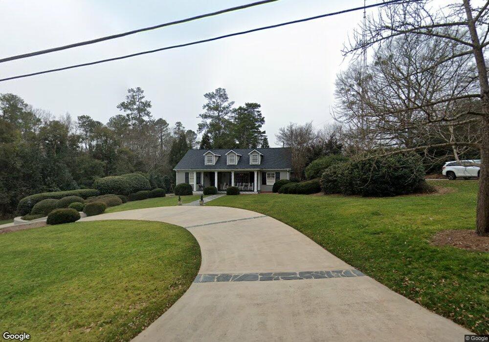
310 Mcwhorter Dr Athens, GA 30606
Five Points NeighborhoodEstimated Value: $996,000 - $1,363,884
4
Beds
4
Baths
3,840
Sq Ft
$321/Sq Ft
Est. Value
About This Home
This home is located at 310 Mcwhorter Dr, Athens, GA 30606 and is currently estimated at $1,231,961, approximately $320 per square foot. 310 Mcwhorter Dr is a home located in Clarke County with nearby schools including Barrow Elementary School, Clarke Middle School, and Clarke Central High School.
Ownership History
Date
Name
Owned For
Owner Type
Purchase Details
Closed on
May 8, 2012
Sold by
Culpepper Katherine C
Bought by
Wingfield William T and Wingfield Fran S
Current Estimated Value
Purchase Details
Closed on
Dec 16, 2008
Sold by
Not Provided
Bought by
Culpepper Katherine C
Purchase Details
Closed on
May 14, 2004
Sold by
Culpepper Kathryn B
Bought by
Culpepper John H and Culp Katherine C
Purchase Details
Closed on
Jan 27, 1994
Sold by
Culpepper E H
Bought by
Culpepper Kathryn B
Create a Home Valuation Report for This Property
The Home Valuation Report is an in-depth analysis detailing your home's value as well as a comparison with similar homes in the area
Home Values in the Area
Average Home Value in this Area
Purchase History
| Date | Buyer | Sale Price | Title Company |
|---|---|---|---|
| Wingfield William T | $692,500 | -- | |
| Culpepper Katherine C | -- | -- | |
| Culpepper John H | $265,000 | -- | |
| Culpepper Kathryn B | -- | -- |
Source: Public Records
Tax History
| Year | Tax Paid | Tax Assessment Tax Assessment Total Assessment is a certain percentage of the fair market value that is determined by local assessors to be the total taxable value of land and additions on the property. | Land | Improvement |
|---|---|---|---|---|
| 2025 | $10,201 | $537,385 | $80,000 | $457,385 |
| 2024 | $10,201 | $508,362 | $74,000 | $434,362 |
| 2023 | $10,297 | $498,951 | $74,000 | $424,951 |
| 2022 | $9,298 | $393,135 | $70,000 | $323,135 |
| 2021 | $9,067 | $339,508 | $70,000 | $269,508 |
| 2020 | $8,770 | $317,832 | $70,000 | $247,832 |
| 2019 | $8,625 | $301,936 | $70,000 | $231,936 |
| 2018 | $7,980 | $255,693 | $70,000 | $185,693 |
| 2017 | $7,728 | $237,630 | $70,000 | $167,630 |
| 2016 | $7,188 | $221,733 | $70,000 | $151,733 |
| 2015 | $6,614 | $204,508 | $60,000 | $144,508 |
| 2014 | $6,247 | $193,450 | $54,000 | $139,450 |
Source: Public Records
Map
Nearby Homes
- 490 Mcwhorter Dr
- 590 Highland Ave
- 195 Rock Glen Rd
- 290 Fortson Dr
- 577 W Cloverhurst Ave
- 224 Fortson Dr
- 206 Fortson Dr
- 112 Fortson Dr
- 1055 Baxter St Unit 406
- 1055 Baxter St Unit 201
- 1075 Baxter St Unit A306
- 1075 Baxter St Unit A304
- 480 W Lake Dr
- 230 Woodlawn Ave
- 589 W Lake Dr
- 338 Springdale St
- 362 W Cloverhurst Ave
- 265 Springdale St
- 104 W Lake Ct
- 665 W Lake Dr
- 320 Mcwhorter Dr
- 823 Bobbin Mill Rd
- 840 Bobbin Mill Rd Unit SI ID1302841P
- 840 Bobbin Mill Rd Unit ID1302846P
- 840 Bobbin Mill Rd Unit ID1302856P
- 840 Bobbin Mill Rd Unit ID1302841P
- 840 Bobbin Mill Rd Unit ID1302820P
- 840 Bobbin Mill Rd Unit ID1302818P
- 840 Bobbin Mill Rd Unit ID1247983P
- 840 Bobbin Mill Rd Unit ID1247977P
- 840 Bobbin Mill Rd Unit ID1247967P
- 840 Bobbin Mill Rd Unit ID1247986P
- 840 Bobbin Mill Rd Unit ID1247970P
- 840 Bobbin Mill Rd Unit ID1247964P
- 840 Bobbin Mill Rd
- 836 Bobbin Mill Rd
- 290 Mcwhorter Dr
- 330 Mcwhorter Dr
- 827 Bobbin Mill Rd
- 293 Mcwhorter Dr
Your Personal Tour Guide
Ask me questions while you tour the home.