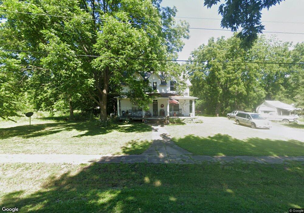
310 N Pennsylvania St Chilhowee, MO 64733
Estimated Value: $145,281 - $234,000
--
Bed
--
Bath
2,304
Sq Ft
$86/Sq Ft
Est. Value
About This Home
This home is located at 310 N Pennsylvania St, Chilhowee, MO 64733 and is currently estimated at $199,070, approximately $86 per square foot. 310 N Pennsylvania St is a home located in Johnson County with nearby schools including Chilhowee Elementary School and Chilhowee High School.
Ownership History
Date
Name
Owned For
Owner Type
Purchase Details
Closed on
Jun 27, 2023
Sold by
Davolt Mike and Davolt Cathy J
Bought by
Reynolds Allen and Reynolds Kay
Current Estimated Value
Purchase Details
Closed on
Apr 25, 2006
Sold by
Jp Morgan Chase Bank
Bought by
Davolt Mike and Davolt Cathy J
Home Financials for this Owner
Home Financials are based on the most recent Mortgage that was taken out on this home.
Original Mortgage
$22,600
Interest Rate
6.32%
Mortgage Type
Future Advance Clause Open End Mortgage
Purchase Details
Closed on
Feb 28, 2006
Sold by
Alexander David T and Alexander Kelly Marie
Bought by
Jpmorgan Chase Bank
Home Financials for this Owner
Home Financials are based on the most recent Mortgage that was taken out on this home.
Original Mortgage
$22,600
Interest Rate
6.32%
Mortgage Type
Future Advance Clause Open End Mortgage
Create a Home Valuation Report for This Property
The Home Valuation Report is an in-depth analysis detailing your home's value as well as a comparison with similar homes in the area
Home Values in the Area
Average Home Value in this Area
Purchase History
| Date | Buyer | Sale Price | Title Company |
|---|---|---|---|
| Reynolds Allen | -- | None Listed On Document | |
| Davolt Mike | -- | -- | |
| Jpmorgan Chase Bank | -- | -- |
Source: Public Records
Mortgage History
| Date | Status | Borrower | Loan Amount |
|---|---|---|---|
| Previous Owner | Davolt Mike | $22,600 |
Source: Public Records
Tax History Compared to Growth
Tax History
| Year | Tax Paid | Tax Assessment Tax Assessment Total Assessment is a certain percentage of the fair market value that is determined by local assessors to be the total taxable value of land and additions on the property. | Land | Improvement |
|---|---|---|---|---|
| 2024 | $480 | $5,610 | $0 | $0 |
| 2023 | $480 | $5,610 | $0 | $0 |
| 2022 | $456 | $5,369 | $0 | $0 |
| 2021 | $456 | $5,369 | $0 | $0 |
| 2020 | $442 | $5,128 | $0 | $0 |
| 2019 | $435 | $5,128 | $0 | $0 |
| 2017 | $420 | $5,128 | $0 | $0 |
| 2016 | $434 | $5,272 | $0 | $0 |
| 2015 | $776 | $5,272 | $0 | $0 |
| 2014 | $761 | $9,103 | $0 | $0 |
Source: Public Records
Map
Nearby Homes
- 924 NW 501 Rd
- 871 SW 301st Rd
- 700 SW 800th Rd
- O Hwy and Sw 1200th Rd
- 0 O Hwy Tracts C and D Hwy Unit HMS2571559
- 1318 NW 911p Rd
- TBD SW 101st Rd
- 1244 SW 101st Rd
- 808 SW O Hwy
- 739 SW 700th Rd
- 169 SW 800th Rd
- 1287 SE State Route 13 N A
- 1246 Missouri 13
- 1287 SE State Route 13
- 10368 NW Highway O
- 833 SW 1101st Rd
- 938 SW 13 Hwy
- 324 N Main St
- 312 N Main St
- 815 SW 520th Rd
- 106 W Pine St
- 306 N Pennsylvania St
- 106 E Pine St
- 201 E Howard St
- 107 E Pine St
- 109 W Pine St
- 107 W Pine St
- 305 N Pennsylvania St
- 202 E Pine St
- 109 E State Route 2
- 107 E State Route 2
- 203 E Pine St
- ?? SW 2 Hwy
- 354 SW State Route 2
- 301 E Howard St
- 207 E State Route 2
- 212 N Pennsylvania St
- 209 E State Route 2
- 128 Missouri 2
- 200 E 2 Hwy