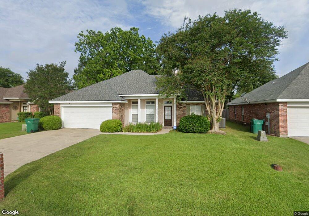
310 Pear Tree Cir Broussard, LA 70518
Estimated Value: $215,000 - $222,000
--
Bed
--
Bath
1,403
Sq Ft
$155/Sq Ft
Est. Value
About This Home
This home is located at 310 Pear Tree Cir, Broussard, LA 70518 and is currently estimated at $217,928, approximately $155 per square foot. 310 Pear Tree Cir is a home located in Lafayette Parish with nearby schools including Katharine Drexel Elementary School, Broussard Middle School, and O. Comeaux High School.
Ownership History
Date
Name
Owned For
Owner Type
Purchase Details
Closed on
Mar 18, 2022
Sold by
Guilbeau Robicheaux Nancy H and Guilbeau Mike
Bought by
Lindon Sydney John
Current Estimated Value
Home Financials for this Owner
Home Financials are based on the most recent Mortgage that was taken out on this home.
Original Mortgage
$195,395
Outstanding Balance
$183,049
Interest Rate
4.16%
Mortgage Type
New Conventional
Estimated Equity
$34,879
Create a Home Valuation Report for This Property
The Home Valuation Report is an in-depth analysis detailing your home's value as well as a comparison with similar homes in the area
Home Values in the Area
Average Home Value in this Area
Purchase History
| Date | Buyer | Sale Price | Title Company |
|---|---|---|---|
| Lindon Sydney John | -- | None Listed On Document |
Source: Public Records
Mortgage History
| Date | Status | Borrower | Loan Amount |
|---|---|---|---|
| Open | Lindon Sydney John | $195,395 | |
| Closed | Lindon Sydney John | $8,000 |
Source: Public Records
Tax History Compared to Growth
Tax History
| Year | Tax Paid | Tax Assessment Tax Assessment Total Assessment is a certain percentage of the fair market value that is determined by local assessors to be the total taxable value of land and additions on the property. | Land | Improvement |
|---|---|---|---|---|
| 2024 | $1,632 | $18,836 | $2,000 | $16,836 |
| 2023 | $1,632 | $16,731 | $2,000 | $14,731 |
| 2022 | $1,446 | $16,731 | $2,000 | $14,731 |
| 2021 | $1,275 | $14,690 | $2,000 | $12,690 |
| 2020 | $1,274 | $14,690 | $2,000 | $12,690 |
| 2019 | $593 | $14,690 | $2,000 | $12,690 |
| 2018 | $606 | $14,690 | $2,000 | $12,690 |
| 2017 | $605 | $14,690 | $2,000 | $12,690 |
| 2015 | $603 | $14,690 | $2,000 | $12,690 |
| 2013 | -- | $14,690 | $2,000 | $12,690 |
Source: Public Records
Map
Nearby Homes
- 104 Bismark Dr
- 102 Riesling Cir
- 1036 Garber Rd
- 108 Portsmouth Dr
- 100 N Eola Rd
- Cali Plan at Oakmont
- Denton Plan at Oakmont
- Justin Plan at Oakmont
- Kingston Plan at Oakmont
- Rosemont Plan at Oakmont
- Huntsville Plan at Oakmont
- Lakeview Plan at Oakmont
- Fargo Plan at Oakmont
- Bellvue Plan at Oakmont
- 101 Snapping Ln
- 104 Tortoise Ln
- 116 Cypress Ridge Rd
- 103 Chattanooga Place
- 111 Tortoise Ln
- 4002 Highway 90 E
- 308 Pear Tree Cir
- 312 Pear Tree Cir
- 306 Pear Tree Cir
- 314 Pear Tree Cir
- 113 Bismark Dr
- 115 Bismark Dr
- 305 Pear Tree Cir
- 111 Bismark Dr
- 117 Bismark Dr
- 307 Pear Tree Cir
- 303 Pear Tree Cir
- 304 Pear Tree Cir
- 316 Pear Tree Cir
- 109 Bismark Dr
- 119 Bismark Dr
- 309 Pear Tree Cir
- 107 Bismark Dr
- 301 Pear Tree Cir
- 311 Pear Tree Cir
- 302 Pear Tree Cir