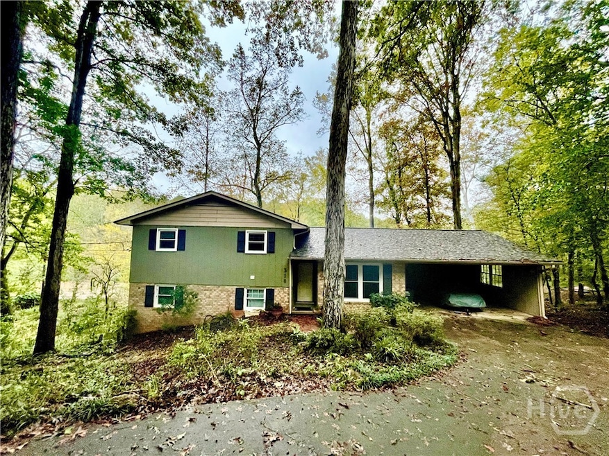
310 Spalding Cir Athens, GA 30605
Estimated payment $2,213/month
Highlights
- River Access
- Waterfront
- Contemporary Architecture
- River View
- Deck
- No HOA
About This Home
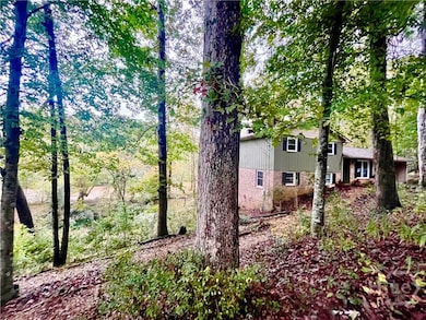
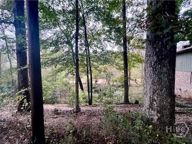
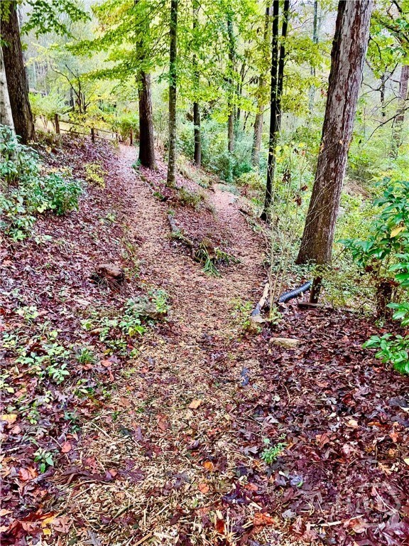
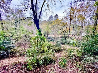
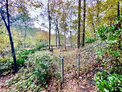
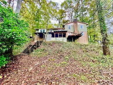
Charming Riverfront living just minutes from UGA & Downtown Athens! Welcome to 310 Spalding Circle, a rare find on a beautiful 0.78-acre lot along the North Oconee River. Nestled at the end of a quiet street, this 4-bedroom, 3-bath home (including two primary suites) offers unmatched privacy, natural beauty, and in-town convenience, just minutes to UGA, Five Points, East Athens, Downtown, and The Loop. You’ll love the soothing sound of river shoals just behind the property, audible even from the front yard. Not to mention the sounds of the birds and bees and the wind thru the trees and easy access to a peaceful swimming hole right in your own backyard. On the main floor you will find the bright Living Room, Dining Room, and Kitchen with smooth-top stove, dishwasher, refrigerator, white ceramic sink, pantry, breakfast nook, and great river views. On the upper level you will find cork floors, full hall bathroom, a bedroom, and an additional bedroom with en-suite bath. There's also an office with wood laminate floors and river views (easy to convert back to a bedroom). On the lower level you will find a cozy family room with carpet, built-ins, wood-burning fireplace & mantle, and access to the back deck. Spacious primary bedroom suite features a tiled bath, soaking tub, and a river rock shower floor. The partially finished basment has Air Conditioned space including a bonus/playroom/den and a bakery kitchen with 3 sinks, hall to a walk-in cooler (ideal for a wine cellar or large fridge), and access to an outdoor pizza oven.Outside you'll enjoy your private river access, shoals, and swimming areas, walking trails through gardens and down to the river, fenced garden area near the water, 2-car carport plus additional gravel parking pad. This is the last house on the river side of Spalding so enjoy the privacy and just a few great neighbors. New roof and double-pane windows in 2022. This home offers incredible potential but does need some TLC. If you’ve been dreaming of riverfront living without leaving town, this is a one-of-a-kind opportunity. Whether you're looking for a private retreat, a homestead with room to garden and grow, or a home with natural beauty just minutes from Athens hotspots, 310 Spalding Circle has it all.
Listing Agent
Daniel Peiken
5Market Realty License #240396 Listed on: 10/28/2025
Home Details
Home Type
- Single Family
Est. Annual Taxes
- $1,998
Year Built
- Built in 1980
Lot Details
- 0.78 Acre Lot
- Waterfront
- No Unit Above or Below
- 6 Pads in the community
- Property is zoned RS-15
Home Design
- Contemporary Architecture
- Traditional Architecture
- Brick Exterior Construction
- Composition Roof
Interior Spaces
- 2,965 Sq Ft Home
- 1-Story Property
- Built-In Features
- Wood Burning Fireplace
- Double Pane Windows
- River Views
Kitchen
- Breakfast Area or Nook
- Oven
- Range
- Dishwasher
Bedrooms and Bathrooms
- 4 Bedrooms
- 3 Full Bathrooms
- Soaking Tub
Laundry
- Laundry in Hall
- Dryer
- Washer
Parking
- 2 Carport Spaces
- On-Street Parking
- Off-Street Parking
Eco-Friendly Details
- Energy-Efficient Windows
Outdoor Features
- River Access
- Deck
- Fire Pit
Schools
- Barnett Elementary School
- Hillsman Middle School
- Cedar Shoals High School
Utilities
- Central Heating and Cooling System
- Heat Pump System
- Gas Water Heater
- Septic Tank
- Cable TV Available
Community Details
- No Home Owners Association
- University Heights Subdivision
Listing and Financial Details
- Tax Lot 17
- Assessor Parcel Number 182A1-A-017
Map
Home Values in the Area
Average Home Value in this Area
Tax History
| Year | Tax Paid | Tax Assessment Tax Assessment Total Assessment is a certain percentage of the fair market value that is determined by local assessors to be the total taxable value of land and additions on the property. | Land | Improvement |
|---|---|---|---|---|
| 2024 | $1,990 | $115,352 | $15,000 | $100,352 |
| 2023 | $686 | $109,060 | $15,000 | $94,060 |
| 2022 | $1,995 | $94,898 | $15,000 | $79,898 |
| 2021 | $1,858 | $77,049 | $15,000 | $62,049 |
| 2020 | $1,787 | $71,859 | $15,000 | $56,859 |
| 2019 | $1,761 | $68,944 | $15,000 | $53,944 |
| 2018 | $1,721 | $66,049 | $15,000 | $51,049 |
| 2017 | $1,599 | $57,294 | $15,000 | $42,294 |
| 2016 | $1,606 | $57,774 | $15,000 | $42,774 |
| 2015 | $1,608 | $57,940 | $15,000 | $42,940 |
| 2014 | $1,625 | $59,150 | $15,000 | $44,150 |
Property History
| Date | Event | Price | List to Sale | Price per Sq Ft |
|---|---|---|---|---|
| 10/28/2025 10/28/25 | For Sale | $389,000 | -- | $131 / Sq Ft |
Purchase History
| Date | Type | Sale Price | Title Company |
|---|---|---|---|
| Warranty Deed | -- | -- | |
| Deed | $104,000 | -- | |
| Deed | $89,000 | -- |
Source: CLASSIC MLS (Athens Area Association of REALTORS®)
MLS Number: CL342219
APN: 182A1-A-017
Disclaimer: Certain information contained herein is derived from information provided by parties other than Homes.com. All information provided is deemed reliable, but is not guaranteed to be accurate and should be independently verified.
![]() IDX information is provided exclusively for personal, non-commercial use, and may not be used for any purpose other than to identify prospective properties consumers may be interested in purchasing. Information is deemed reliable but not guaranteed.
IDX information is provided exclusively for personal, non-commercial use, and may not be used for any purpose other than to identify prospective properties consumers may be interested in purchasing. Information is deemed reliable but not guaranteed.
- 152 Spalding Ct
- 340 Caldwell Cir
- 156 Fernbanks Ct
- 100 Woodstone Dr Unit 12
- 100 Woodstone Dr Unit 10
- 205 Woodstone Dr
- 205 Woodstone Dr Unit 14
- 325 Segrest Cir
- 1029 College Station Rd
- 1025 College Station Rd
- 1067 College Station Rd
- 105 Segrest Cir
- 411 College Cir
- 160 Cedar Rock Trace
- 2165 S Milledge Ave Unit F4
- 425 Riverbend Pkwy
- 100 Woodstone Dr Unit ID1302836P
- 195 Woodstone Dr
- 205 Woodstone Dr Unit 18
- 240 Segrest Cir
- 355 Riverbend Pkwy
- 1005 College Station Rd
- 192 Cedar Rock Trace
- 1000 Lakeside Dr
- 175 International Dr
- 2085 S Milledge Ave
- 236 Center Park Ln
- 130 Whitehall Rd Unit ID1302858P
- 255 Research Dr
- 585 White Cir Unit 406
- 625 Whitehall Rd Unit B
- 625 Whitehall Rd Unit A
- 127 Pineview Dr
- 110 International Dr
- 1909 S Milledge Ave Unit 2