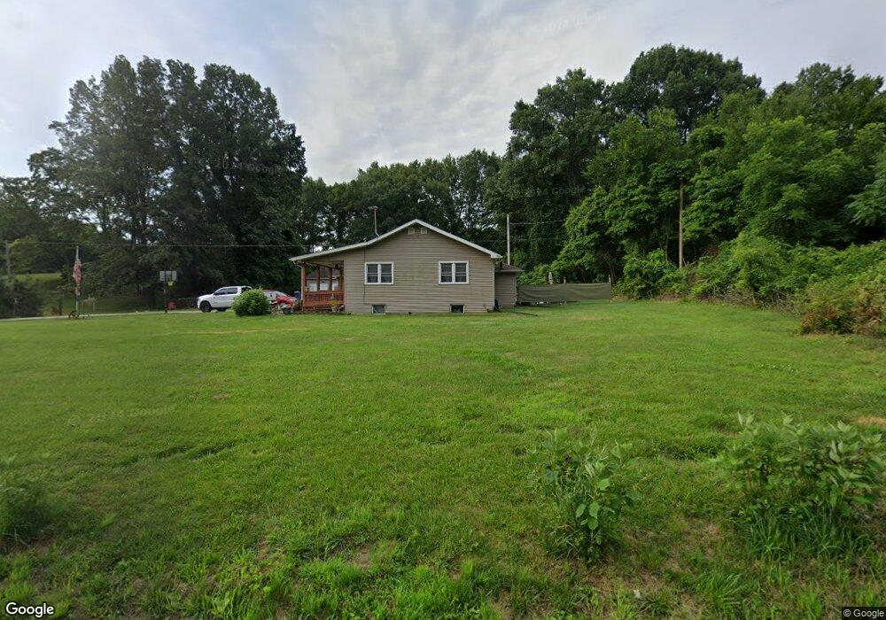
3102 W 450 N La Porte, IN 46350
Estimated Value: $270,000 - $335,000
3
Beds
2
Baths
1,729
Sq Ft
$173/Sq Ft
Est. Value
About This Home
This home is located at 3102 W 450 N, La Porte, IN 46350 and is currently estimated at $299,145, approximately $173 per square foot. 3102 W 450 N is a home located in LaPorte County with nearby schools including Prescott Elementary School, F. Willard Crichfield Elementary School, and La Porte High School.
Ownership History
Date
Name
Owned For
Owner Type
Purchase Details
Closed on
Oct 8, 2021
Sold by
Jerndt Kevin A
Bought by
Jerndt Kevin A and Jerndt Anita L
Current Estimated Value
Purchase Details
Closed on
Sep 20, 2010
Sold by
Lehman Matthew D and Lehman Jacqueline
Bought by
Jerndt Kevin A and Jerndt Norman R
Home Financials for this Owner
Home Financials are based on the most recent Mortgage that was taken out on this home.
Original Mortgage
$156,590
Interest Rate
4.45%
Mortgage Type
FHA
Create a Home Valuation Report for This Property
The Home Valuation Report is an in-depth analysis detailing your home's value as well as a comparison with similar homes in the area
Home Values in the Area
Average Home Value in this Area
Purchase History
| Date | Buyer | Sale Price | Title Company |
|---|---|---|---|
| Jerndt Kevin A | -- | None Listed On Document | |
| Jerndt Kevin A | -- | Meridian Title Corp |
Source: Public Records
Mortgage History
| Date | Status | Borrower | Loan Amount |
|---|---|---|---|
| Previous Owner | Jerndt Kevin A | $156,590 |
Source: Public Records
Tax History Compared to Growth
Tax History
| Year | Tax Paid | Tax Assessment Tax Assessment Total Assessment is a certain percentage of the fair market value that is determined by local assessors to be the total taxable value of land and additions on the property. | Land | Improvement |
|---|---|---|---|---|
| 2024 | $1,350 | $185,900 | $72,200 | $113,700 |
| 2022 | $1,384 | $153,000 | $41,400 | $111,600 |
| 2021 | $1,068 | $132,000 | $27,700 | $104,300 |
| 2020 | $1,222 | $132,000 | $27,700 | $104,300 |
| 2019 | $1,268 | $146,900 | $27,700 | $119,200 |
| 2018 | $1,190 | $138,900 | $27,700 | $111,200 |
| 2017 | $1,023 | $129,500 | $27,700 | $101,800 |
| 2016 | $1,233 | $151,800 | $25,400 | $126,400 |
| 2014 | $1,204 | $152,500 | $25,400 | $127,100 |
Source: Public Records
Map
Nearby Homes
- 4291 U S 35
- 0 N Rue du Lac Ct
- 00 N Rue du Lac Ct
- 00 W Valley Blvd
- 3959 N 400 W
- 5034 N 400 W
- 000 N US Highway 35 Rd
- 4079 W Schultz Rd
- 0 N Hwy 39 N Unit NRA813838
- 3226 N Briar Leaf Ct
- 3471 N Karen Kourt
- Lot 5 Malaga Dr W
- 0 Nicomus Path
- 2842 N Palmer Ave
- 2826 N Palmer Ave
- 4678 W Schultz Rd
- 00 Pawnee Trail
- 000 Pawnee Trail
- 2776 Hogan Ave
- 2776 W Hogan Dr
- 3122 W 450 N
- 3085 W 450 N
- 3014 W 450 N
- 2986 W 450 N
- 2979 W 450 N
- 4455 N 325 W
- 3237 W 450 N
- 2957 W 450 N
- 2892 W 450 N
- 3198 W Shorewood Dr
- 4504 N 325 W
- 3231 W Shorewood Dr
- 3012 W Shorewood Dr
- 3222 W Shorewood Dr
- 19 W Shorewood Dr
- 18 W Shorewood Dr
- Lot 18 W Shorewood Dr
- Lot 19 W Shorewood Dr
- 13 W Shorewood Dr
- 3132 W Shorewood Dr