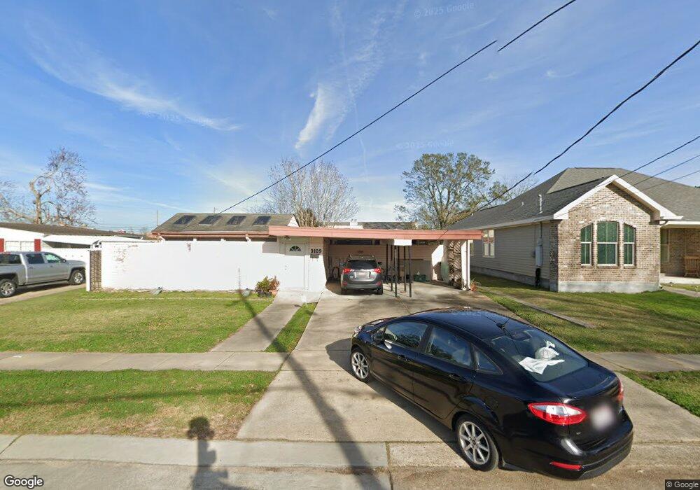
3109 Haring Rd Metairie, LA 70006
Clearview-Transcontinental NeighborhoodEstimated Value: $190,000 - $256,000
3
Beds
2
Baths
1,300
Sq Ft
$178/Sq Ft
Est. Value
About This Home
This home is located at 3109 Haring Rd, Metairie, LA 70006 and is currently estimated at $231,438, approximately $178 per square foot. 3109 Haring Rd is a home located in Jefferson Parish with nearby schools including Phoebe Hearst School, Airline Park Academy For Advanced Studies, and John Q. Adams Middle School.
Ownership History
Date
Name
Owned For
Owner Type
Purchase Details
Closed on
Aug 13, 2008
Sold by
Mckearan Mary A L
Bought by
Largaespada Jorge L
Current Estimated Value
Home Financials for this Owner
Home Financials are based on the most recent Mortgage that was taken out on this home.
Original Mortgage
$111,600
Outstanding Balance
$73,426
Interest Rate
6.38%
Mortgage Type
New Conventional
Estimated Equity
$158,012
Create a Home Valuation Report for This Property
The Home Valuation Report is an in-depth analysis detailing your home's value as well as a comparison with similar homes in the area
Home Values in the Area
Average Home Value in this Area
Purchase History
| Date | Buyer | Sale Price | Title Company |
|---|---|---|---|
| Largaespada Jorge L | $124,000 | -- |
Source: Public Records
Mortgage History
| Date | Status | Borrower | Loan Amount |
|---|---|---|---|
| Open | Largaespada Jorge L | $111,600 |
Source: Public Records
Tax History Compared to Growth
Tax History
| Year | Tax Paid | Tax Assessment Tax Assessment Total Assessment is a certain percentage of the fair market value that is determined by local assessors to be the total taxable value of land and additions on the property. | Land | Improvement |
|---|---|---|---|---|
| 2024 | $6,616 | $13,420 | $9,350 | $4,070 |
| 2023 | $676 | $12,640 | $9,350 | $3,290 |
| 2022 | $1,619 | $12,640 | $9,350 | $3,290 |
| 2021 | $1,504 | $12,640 | $9,350 | $3,290 |
| 2020 | $1,493 | $12,640 | $9,350 | $3,290 |
| 2019 | $1,535 | $12,640 | $9,350 | $3,290 |
| 2018 | $583 | $12,640 | $9,350 | $3,290 |
| 2017 | $1,433 | $12,640 | $9,350 | $3,290 |
| 2016 | $1,406 | $12,640 | $9,350 | $3,290 |
| 2015 | $551 | $12,400 | $9,350 | $3,050 |
| 2014 | $551 | $12,400 | $9,350 | $3,050 |
Source: Public Records
Map
Nearby Homes
- 2913 Jessica St
- 5240 Trenton St
- 3405 Haring Rd
- 5021 Newlands St
- 6101 Marcie St
- 5800 Marcie St
- 6109 Marcie St
- 3516 Transcontinental Dr
- 5237 Meadowdale St
- 4917 Rye St
- 4924 Sanford St
- 2801 Ingrid Ln
- 3609 Green Acres Rd
- 2817 Transcontinental Dr
- 2608 Winifred St
- 5613 Morton St
- 2412 Green Acres Rd
- 5012 Jasper St
- 3609 James Dr
- 5013 Wabash St
- 3113 Haring Rd
- 3105 Haring Rd
- 3121 Haring Rd
- 5244 Quincy St Unit A
- 5244 Quincy St Unit C
- 5244 Quincy St Unit B
- 5244 Quincy St
- 3101 Haring Rd
- 3108 Haring Rd
- 3104 Haring Rd
- 3112 Haring Rd
- 3021 Haring Rd
- 5245 Rye St
- 5240 Quincy St
- 5240 Quincy St
- 5240 Quincy St
- 5240 Quincy St Unit 1
- 5240 Quincy St Unit 4
- 5240 Quincy St Unit 3
- 5240 Quincy St Unit 2