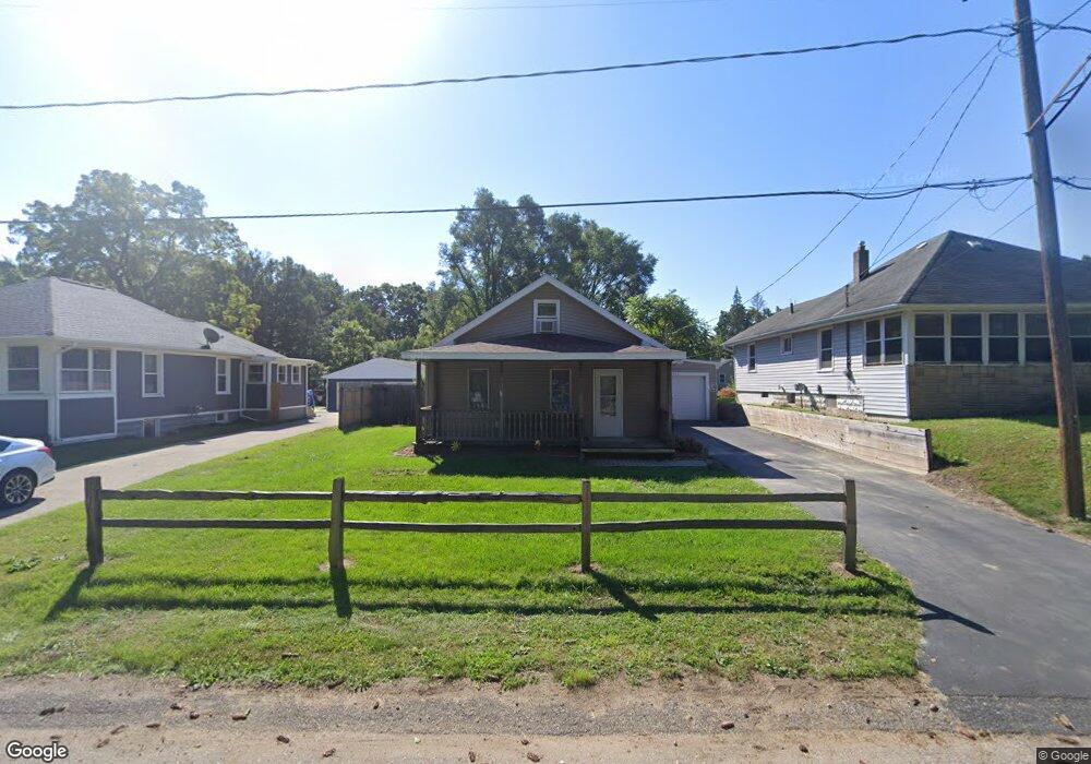
3111 Matthews St Unit MATTHEWS ST Jackson, MI 49203
Estimated Value: $125,000 - $144,000
3
Beds
1
Bath
936
Sq Ft
$141/Sq Ft
Est. Value
About This Home
This home is located at 3111 Matthews St Unit MATTHEWS ST, Jackson, MI 49203 and is currently estimated at $132,413, approximately $141 per square foot. 3111 Matthews St Unit MATTHEWS ST is a home located in Jackson County with nearby schools including East Jackson Elementary School, East Jackson Middle School, and East Jackson High School.
Ownership History
Date
Name
Owned For
Owner Type
Purchase Details
Closed on
Apr 2, 2018
Sold by
Mackinder Tommy Joe and Mackinder Pamela Sue
Bought by
Mackinder Tommy J and Mackinder Pamela S
Current Estimated Value
Purchase Details
Closed on
Nov 24, 2008
Sold by
Homecomings Financial Network Inc
Bought by
The Bank Of New York Mellon Trust Compan and Ramp 2006Sp2
Purchase Details
Closed on
Oct 20, 1999
Sold by
Mccollum Cameron D and Mccollum Patricia
Bought by
Mccollum Jessica
Create a Home Valuation Report for This Property
The Home Valuation Report is an in-depth analysis detailing your home's value as well as a comparison with similar homes in the area
Home Values in the Area
Average Home Value in this Area
Purchase History
| Date | Buyer | Sale Price | Title Company |
|---|---|---|---|
| Mackinder Tommy J | -- | None Available | |
| The Bank Of New York Mellon Trust Compan | -- | E Title Agency | |
| Mccollum Jessica | $30,000 | Title Office |
Source: Public Records
Tax History Compared to Growth
Tax History
| Year | Tax Paid | Tax Assessment Tax Assessment Total Assessment is a certain percentage of the fair market value that is determined by local assessors to be the total taxable value of land and additions on the property. | Land | Improvement |
|---|---|---|---|---|
| 2025 | $1,519 | $49,283 | $0 | $0 |
| 2024 | $1,037 | $43,606 | $0 | $0 |
| 2023 | $996 | $43,439 | $0 | $0 |
| 2022 | $1,211 | $36,174 | $0 | $0 |
| 2021 | $1,185 | $33,138 | $0 | $0 |
| 2020 | $1,172 | $27,024 | $0 | $0 |
| 2019 | $1,137 | $24,877 | $0 | $0 |
| 2018 | $1,108 | $22,962 | $795 | $22,167 |
| 2017 | $1,060 | $21,927 | $0 | $0 |
| 2016 | $844 | $21,241 | $21,241 | $0 |
| 2015 | -- | $20,013 | $20,013 | $0 |
| 2014 | -- | $23,449 | $23,449 | $0 |
| 2013 | -- | $23,449 | $23,449 | $0 |
Source: Public Records
Map
Nearby Homes
- 539 S Dettman Rd
- 698 S Dettman Rd
- 324 Amos St
- Vl Watts St
- 210 Watts Rd
- 2718 Page Ave
- vl Seymour Rd
- Unit 48 Sanctuary Dr
- Unit 55 Sanctuary Dr
- Unit 50 Sanctuary Dr
- Unit 28 Sanctuary Dr
- Unit 53, 5 Sanctuary Dr
- Unit 53 Sanctuary Dr
- Unit 48,49 Sanctuary Dr
- 210 S Forbes St
- 130 N Horton St
- 133 N Forbes St
- 318 Seneca Dr
- 2016 Pringle Ave
- 2013 Tyson St
- 3111 Matthews St
- 3109 Matthews St
- 3119 Matthews St
- 501 S Dettman Rd
- 3129 Matthews St
- 3122 Matthews St
- 3135 Matthews St
- 433 S Dettman Rd
- 523 S Dettman Rd
- 506 S Dettman Rd
- 3141 Matthews St
- 3134 Matthews St
- 444 S Dettman Rd
- 3140 Matthews St
- 429 S Dettman Rd
- 531 S Dettman Rd
- 430 S Dettman Rd
- 3154 Matthews St
- 537 S Dettman Rd
- 417 S Dettman Rd