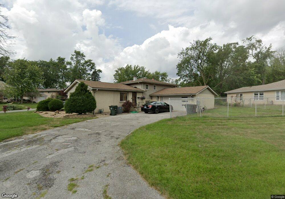
3112 Lexington Dr Hazel Crest, IL 60429
Estimated Value: $160,000 - $240,000
4
Beds
2
Baths
1,512
Sq Ft
$139/Sq Ft
Est. Value
About This Home
This home is located at 3112 Lexington Dr, Hazel Crest, IL 60429 and is currently estimated at $210,582, approximately $139 per square foot. 3112 Lexington Dr is a home located in Cook County with nearby schools including Mae Jemison School, Prairie-Hills Junior High School, and Hillcrest High School.
Ownership History
Date
Name
Owned For
Owner Type
Purchase Details
Closed on
Jun 5, 2018
Sold by
Clark Anthony
Bought by
Roundtree Teresa
Current Estimated Value
Purchase Details
Closed on
Nov 8, 2002
Sold by
Anderson Edward
Bought by
Clark Anthony
Home Financials for this Owner
Home Financials are based on the most recent Mortgage that was taken out on this home.
Original Mortgage
$113,600
Interest Rate
6.38%
Create a Home Valuation Report for This Property
The Home Valuation Report is an in-depth analysis detailing your home's value as well as a comparison with similar homes in the area
Home Values in the Area
Average Home Value in this Area
Purchase History
| Date | Buyer | Sale Price | Title Company |
|---|---|---|---|
| Roundtree Teresa | $97,500 | Timios Inc | |
| Clark Anthony | -- | -- |
Source: Public Records
Mortgage History
| Date | Status | Borrower | Loan Amount |
|---|---|---|---|
| Previous Owner | Clark Anthony | $113,600 |
Source: Public Records
Tax History Compared to Growth
Tax History
| Year | Tax Paid | Tax Assessment Tax Assessment Total Assessment is a certain percentage of the fair market value that is determined by local assessors to be the total taxable value of land and additions on the property. | Land | Improvement |
|---|---|---|---|---|
| 2024 | $8,035 | $19,000 | $3,606 | $15,394 |
| 2023 | $4,246 | $19,000 | $3,606 | $15,394 |
| 2022 | $4,246 | $9,205 | $3,051 | $6,154 |
| 2021 | $4,156 | $9,204 | $3,050 | $6,154 |
| 2020 | $4,922 | $10,429 | $3,050 | $7,379 |
| 2019 | $7,188 | $10,735 | $2,773 | $7,962 |
| 2018 | $4,736 | $10,735 | $2,773 | $7,962 |
| 2017 | $4,462 | $10,735 | $2,773 | $7,962 |
| 2016 | $4,548 | $10,277 | $2,496 | $7,781 |
| 2015 | $4,287 | $10,277 | $2,496 | $7,781 |
| 2014 | $4,211 | $10,277 | $2,496 | $7,781 |
| 2013 | $3,549 | $10,040 | $2,496 | $7,544 |
Source: Public Records
Map
Nearby Homes
- 3107 Longfellow Ave
- 17405 Longfellow Ave
- 17410 Emerson Ave
- 17303 Kedzie Ave
- 3004 Longfellow Ave
- 3003 Longfellow Ave
- 17311 Burr Oak Ln
- 2912 175th St
- 3213 Woodworth Place
- 17306 Burr Oak Ln
- 7 E Carriageway Dr Unit 311
- 2900 175th St
- 5 E Carriageway Dr Unit 210
- 2818 Tennyson Place
- 3205 Oak Ct
- 2814 Lexington Dr
- 2810 Lexington Dr
- 3317 Woodworth Place
- 17622 Oakwood Dr
- 3012 171st St Unit 2E
- 17413 Poe Ave
- 3110 Lexington Dr
- 3119 Lexington Dr
- 17414 Poe Ave
- 17411 Poe Ave
- 3115 Lexington Dr
- 17412 Poe Ave
- 17416 Poe Ave
- 3117 Lexington Dr
- 3113 Lexington Dr
- 3108 Lexington Dr
- 17410 Poe Ave
- 3111 Lexington Dr
- 17408 Poe Ave
- 3124 175th St
- 17407 Poe Ave
- 17407 Poe Ave
- 17418 Bryant Ln
- 17417 Kedzie Ave
- 17415 Kedzie Ave