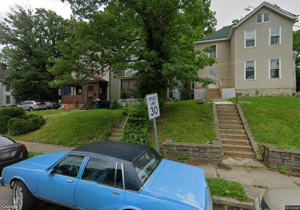
3114 Durrell Ave Cincinnati, OH 45207
Evanston NeighborhoodEstimated Value: $204,415 - $293,000
3
Beds
2
Baths
1,788
Sq Ft
$137/Sq Ft
Est. Value
About This Home
This home is located at 3114 Durrell Ave, Cincinnati, OH 45207 and is currently estimated at $244,104, approximately $136 per square foot. 3114 Durrell Ave is a home located in Hamilton County with nearby schools including Evanston Academy Elementary School, Clark Montessori High School, and Robert A. Taft Information Technology High School.
Ownership History
Date
Name
Owned For
Owner Type
Purchase Details
Closed on
May 31, 2000
Sold by
Gee David R
Bought by
Mitchell Frances and Mitchell Frank
Current Estimated Value
Home Financials for this Owner
Home Financials are based on the most recent Mortgage that was taken out on this home.
Original Mortgage
$70,750
Outstanding Balance
$29,419
Interest Rate
11.75%
Estimated Equity
$214,685
Purchase Details
Closed on
Jun 2, 1999
Sold by
Louise Shannon and Louise Paul L
Bought by
Gee David R
Purchase Details
Closed on
May 24, 1999
Sold by
Shannon Steven L and Shannon Gloria L
Bought by
Gee David R
Create a Home Valuation Report for This Property
The Home Valuation Report is an in-depth analysis detailing your home's value as well as a comparison with similar homes in the area
Home Values in the Area
Average Home Value in this Area
Purchase History
| Date | Buyer | Sale Price | Title Company |
|---|---|---|---|
| Mitchell Frances | $85,000 | -- | |
| Gee David R | $11,500 | -- | |
| Gee David R | $11,500 | -- |
Source: Public Records
Mortgage History
| Date | Status | Borrower | Loan Amount |
|---|---|---|---|
| Open | Mitchell Frances | $70,750 | |
| Closed | Mitchell Frances | $10,000 |
Source: Public Records
Tax History
| Year | Tax Paid | Tax Assessment Tax Assessment Total Assessment is a certain percentage of the fair market value that is determined by local assessors to be the total taxable value of land and additions on the property. | Land | Improvement |
|---|---|---|---|---|
| 2025 | $1,941 | $41,644 | $6,031 | $35,613 |
| 2023 | $1,980 | $41,644 | $6,031 | $35,613 |
| 2022 | $720 | $19,307 | $4,379 | $14,928 |
| 2021 | $678 | $19,307 | $4,379 | $14,928 |
| 2020 | $714 | $19,307 | $4,379 | $14,928 |
| 2019 | $659 | $17,714 | $4,018 | $13,696 |
| 2018 | $661 | $17,714 | $4,018 | $13,696 |
| 2017 | $619 | $17,714 | $4,018 | $13,696 |
| 2016 | $621 | $17,704 | $4,358 | $13,346 |
| 2015 | $567 | $17,704 | $4,358 | $13,346 |
| 2014 | $572 | $17,704 | $4,358 | $13,346 |
| 2013 | $605 | $18,064 | $4,445 | $13,619 |
Source: Public Records
Map
Nearby Homes
- 1521 Merrimac St
- 1541 Merrimac St
- 3206 Gilbert Ave
- 3238 Gilbert Ave
- 3217 Gilbert Ave
- 3138 Woodburn Ave
- 1534 Dixmont Ave
- 1613 Dexter Ave
- 3129 Hackberry St
- 1623 Dexter Ave
- 3121 Hackberry St
- 3119 Hackberry St
- 1506 Dixmont Ave
- 1517 Saint Leger Place
- 1628 Dexter Ave
- 3120 Hackberry St
- 1627 Everly Place
- 1607 Everly Place
- 3008 Woodburn Ave
- 1611 Everly Place
- 3118 Durrell Ave
- 3112 Durrell Ave
- 3122 Durrell Ave
- 3108 Durrell Ave
- 3106 Durrell Ave
- 3126 Durrell Ave
- 3111 Harvard Ave
- 3117 Harvard Ave
- 1514 Merrimac St
- 3113 Harvard Ave
- 1506 Merrimac St
- 1508 Merrimac St
- 1504 Merrimac St
- 1502 Merrimac St
- 3123 Harvard Ave
- 1518 Merrimac St
- 1500 Merrimac St
- 3125 Harvard Ave
- 1520 Merrimac St
- 3130 Durrell Ave
Your Personal Tour Guide
Ask me questions while you tour the home.