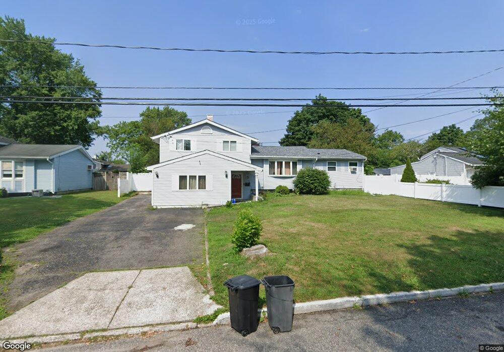
3114 Newport Ave Medford, NY 11763
Estimated Value: $545,795 - $595,000
5
Beds
2
Baths
1,493
Sq Ft
$382/Sq Ft
Est. Value
About This Home
This home is located at 3114 Newport Ave, Medford, NY 11763 and is currently estimated at $570,699, approximately $382 per square foot. 3114 Newport Ave is a home located in Suffolk County with nearby schools including Patchogue-Medford High School and Long Island Baptist Academy.
Ownership History
Date
Name
Owned For
Owner Type
Purchase Details
Closed on
Jun 23, 2022
Sold by
Muy Anibal and Romero Yanira
Bought by
Muy Anibal and Muy Erika
Current Estimated Value
Purchase Details
Closed on
Jul 1, 2015
Sold by
Haberstroh William
Bought by
Muy Anibal and Muy Erika
Home Financials for this Owner
Home Financials are based on the most recent Mortgage that was taken out on this home.
Original Mortgage
$260,200
Interest Rate
4.01%
Mortgage Type
FHA
Purchase Details
Closed on
Dec 17, 1996
Sold by
Haberstroh William and Haberstroh Karen G
Bought by
Haberstroh William
Create a Home Valuation Report for This Property
The Home Valuation Report is an in-depth analysis detailing your home's value as well as a comparison with similar homes in the area
Home Values in the Area
Average Home Value in this Area
Purchase History
| Date | Buyer | Sale Price | Title Company |
|---|---|---|---|
| Muy Anibal | -- | None Available | |
| Muy Anibal | $265,000 | Coach Title | |
| Haberstroh William | -- | American Title Ins Co |
Source: Public Records
Mortgage History
| Date | Status | Borrower | Loan Amount |
|---|---|---|---|
| Previous Owner | Muy Anibal | $260,200 |
Source: Public Records
Tax History Compared to Growth
Tax History
| Year | Tax Paid | Tax Assessment Tax Assessment Total Assessment is a certain percentage of the fair market value that is determined by local assessors to be the total taxable value of land and additions on the property. | Land | Improvement |
|---|---|---|---|---|
| 2024 | $10,021 | $2,285 | $160 | $2,125 |
| 2023 | $10,021 | $2,285 | $160 | $2,125 |
| 2022 | $8,977 | $2,285 | $160 | $2,125 |
| 2021 | $8,977 | $2,285 | $160 | $2,125 |
| 2020 | $9,216 | $2,285 | $160 | $2,125 |
| 2019 | $9,216 | $0 | $0 | $0 |
| 2018 | $8,693 | $2,285 | $160 | $2,125 |
| 2017 | $8,693 | $2,285 | $160 | $2,125 |
| 2016 | $8,522 | $2,285 | $160 | $2,125 |
| 2015 | -- | $2,285 | $160 | $2,125 |
| 2014 | -- | $2,090 | $160 | $1,930 |
Source: Public Records
Map
Nearby Homes
- 1600 Fire Ave
- 3115 Chestnut Ave
- 3106 Devon Ave
- 49 Country Rd
- 3004 New London Ave
- 1401 Race Ave
- 1301 Race Ave
- 1300 Race Ave
- 241 Middle Island Rd
- 1902 Race Ave
- 2905 Beechnut Ave
- 0 Cedar Ln Unit ONE3556748
- 3019 Sipp Ave
- 2405 Fire Ave
- 2816 Acorn Ave
- 3110 Kane Ave
- 2401 Race Ave
- 2909 Falcon Ave
- 3115 Heather Ave
- 392 Birchwood Rd
- 3118 Newport Ave
- 3112 Newport Ave
- 3117 Beechnut Ave
- 3119 Beechnut Ave
- 3115 Beechnut Ave
- 1502 Fire Ave
- 3110 Newport Ave
- 3117 Newport Ave
- 1500 Fire Ave
- 3119 Newport Ave
- 3111 Beechnut Ave
- 3115 Newport Ave
- 3111 Newport Ave
- 3108 Newport Ave
- 3109 Beechnut Ave
- 3112 Beechnut Ave
- 3116 Beechnut Ave
- 3114 Chestnut Ave
- 3116 Chestnut Ave
- 3112 Chestnut Ave