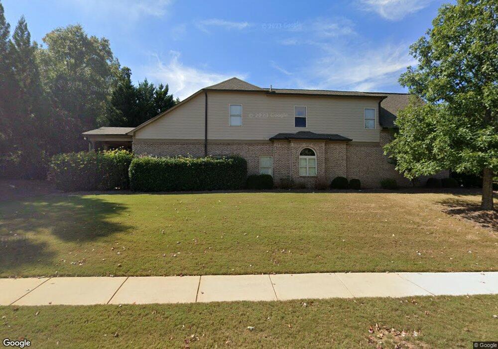
312 Bakers Farm Cir Braselton, GA 30517
Estimated Value: $489,000 - $562,000
5
Beds
4
Baths
3,392
Sq Ft
$154/Sq Ft
Est. Value
About This Home
This home is located at 312 Bakers Farm Cir, Braselton, GA 30517 and is currently estimated at $522,556, approximately $154 per square foot. 312 Bakers Farm Cir is a home located in Jackson County with nearby schools including West Jackson Elementary School, West Jackson Middle School, and Jackson County High School.
Ownership History
Date
Name
Owned For
Owner Type
Purchase Details
Closed on
Jul 13, 2009
Sold by
May George Gordon
Bought by
Holman William Earl
Current Estimated Value
Home Financials for this Owner
Home Financials are based on the most recent Mortgage that was taken out on this home.
Original Mortgage
$191,800
Outstanding Balance
$126,573
Interest Rate
5.53%
Mortgage Type
New Conventional
Estimated Equity
$395,983
Purchase Details
Closed on
Aug 17, 2007
Sold by
Not Provided
Bought by
Holman William Earl
Purchase Details
Closed on
Jan 10, 2007
Sold by
Not Provided
Bought by
Holman William Earl
Purchase Details
Closed on
Jun 15, 2005
Sold by
Braselton Ventures Llc
Bought by
Bts Properties Ii Llc
Create a Home Valuation Report for This Property
The Home Valuation Report is an in-depth analysis detailing your home's value as well as a comparison with similar homes in the area
Home Values in the Area
Average Home Value in this Area
Purchase History
| Date | Buyer | Sale Price | Title Company |
|---|---|---|---|
| Holman William Earl | $274,000 | -- | |
| Holman William Earl | $380,900 | -- | |
| Holman William Earl | $85,000 | -- | |
| Bts Properties Ii Llc | $5,352,600 | -- |
Source: Public Records
Mortgage History
| Date | Status | Borrower | Loan Amount |
|---|---|---|---|
| Open | Holman William Earl | $191,800 |
Source: Public Records
Tax History Compared to Growth
Tax History
| Year | Tax Paid | Tax Assessment Tax Assessment Total Assessment is a certain percentage of the fair market value that is determined by local assessors to be the total taxable value of land and additions on the property. | Land | Improvement |
|---|---|---|---|---|
| 2024 | $3,812 | $220,960 | $26,240 | $194,720 |
| 2023 | $5,361 | $199,840 | $26,240 | $173,600 |
| 2022 | $4,347 | $166,360 | $26,240 | $140,120 |
| 2021 | $4,393 | $166,360 | $26,240 | $140,120 |
| 2020 | $3,686 | $135,720 | $26,240 | $109,480 |
| 2019 | $4,244 | $149,400 | $26,240 | $123,160 |
| 2018 | $4,067 | $143,480 | $26,240 | $117,240 |
| 2017 | $3,704 | $132,796 | $26,240 | $106,556 |
| 2016 | $4,034 | $141,348 | $25,000 | $116,348 |
| 2015 | $3,368 | $122,808 | $12,000 | $110,808 |
| 2014 | $3,105 | $118,000 | $12,000 | $106,000 |
| 2013 | -- | $118,000 | $12,000 | $106,000 |
Source: Public Records
Map
Nearby Homes
- 306 Bakers Farm Cir
- 153 Bakers Farm Cir
- 300 Bakers Farm Cir
- 147 Bakers Farm Cir
- 172 Bakers Farm Cir
- 159 Bakers Farm Cir
- 165 Bakers Farm Cir
- 141 Bakers Farm Cir
- 0 Bakers Farm Cir Unit 8648014
- 0 Bakers Farm Cir Unit 8346498
- 0 Bakers Farm Cir Unit 8293611
- 0 Bakers Farm Cir Unit 8150714
- 0 Bakers Farm Cir Unit 8571427
- 0 Bakers Farm Cir Unit 8503821
- 0 Bakers Farm Cir Unit 8853608
- 0 Bakers Farm Cir Unit 3084986
- 0 Bakers Farm Cir Unit 7107520
- 171 Bakers Farm Cir Unit 12
- 171 Bakers Farm Cir
- 178 Bakers Farm Cir