Estimated Value: $231,139 - $255,000
--
Bed
1
Bath
1,040
Sq Ft
$234/Sq Ft
Est. Value
About This Home
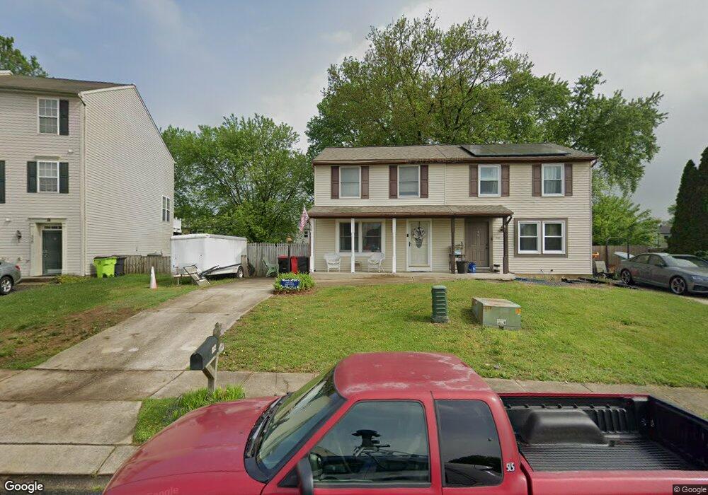
This home is located at 312 Brittany Dr, Joppa, MD 21085 and is currently estimated at $243,535, approximately $234 per square foot. 312 Brittany Dr is a home located in Harford County with nearby schools including Riverside Elementary School, Magnolia Middle School, and Joppatowne High School.
Ownership History
Date
Name
Owned For
Owner Type
Purchase Details
Closed on
Dec 2, 2004
Sold by
Warble Dennis Autry
Bought by
Lord Jason
Current Estimated Value
Purchase Details
Closed on
Jun 30, 2004
Sold by
Warble Dennis Autry
Bought by
Lord Jason
Purchase Details
Closed on
Aug 24, 2000
Sold by
Warble Dennis Autry
Bought by
Warble Dennis Autry
Purchase Details
Closed on
Jun 28, 1996
Sold by
Davis Stewart W
Bought by
Warble Dennis Autry and Warble Carmella Esther
Create a Home Valuation Report for This Property
The Home Valuation Report is an in-depth analysis detailing your home's value as well as a comparison with similar homes in the area
Home Values in the Area
Average Home Value in this Area
Purchase History
| Date | Buyer | Sale Price | Title Company |
|---|---|---|---|
| Lord Jason | $140,000 | -- | |
| Lord Jason | $140,000 | -- | |
| Warble Dennis Autry | -- | -- | |
| Warble Dennis Autry | $86,000 | -- |
Source: Public Records
Mortgage History
| Date | Status | Borrower | Loan Amount |
|---|---|---|---|
| Closed | Lord Jason | -- |
Source: Public Records
Tax History Compared to Growth
Tax History
| Year | Tax Paid | Tax Assessment Tax Assessment Total Assessment is a certain percentage of the fair market value that is determined by local assessors to be the total taxable value of land and additions on the property. | Land | Improvement |
|---|---|---|---|---|
| 2025 | $1,923 | $190,133 | $0 | $0 |
| 2024 | $1,923 | $176,400 | $55,000 | $121,400 |
| 2023 | $1,850 | $169,700 | $0 | $0 |
| 2022 | $1,777 | $163,000 | $0 | $0 |
| 2021 | $1,724 | $156,300 | $55,000 | $101,300 |
| 2020 | $1,724 | $149,367 | $0 | $0 |
| 2019 | $1,642 | $142,433 | $0 | $0 |
| 2018 | $1,550 | $135,500 | $55,000 | $80,500 |
| 2017 | $1,519 | $135,500 | $0 | $0 |
| 2016 | -- | $130,100 | $0 | $0 |
| 2015 | $1,606 | $127,400 | $0 | $0 |
| 2014 | $1,606 | $127,400 | $0 | $0 |
Source: Public Records
Map
Nearby Homes
- 259 Foster Knoll Dr
- 408 Berkshire Ct
- 120 Haverhill Rd
- 304 Foster Knoll Dr
- 116 Trails Way
- 304 Avedon Ct
- 403 Dunfield Ct
- 225 Haverhill Rd
- 404 Dunfield Ct
- 233 Haverhill Rd
- 406 Fowler Ct
- 221 Kershaw Ct
- 219 Kearney Dr
- 343 Hackley Dr
- 345 Hackley Dr
- 338 Hackley Dr
- 226 Kearney Dr
- 355 Hackley Dr
- 231 Joppa Farm Rd
- 509 Foster Knoll Dr
- 310 Brittany Dr
- 314 Brittany Dr
- 308 Brittany Dr
- 316 Brittany Dr
- 306 Brittany Dr
- 305 Oakway Ct
- 318 Brittany Dr
- 307 Oakway Ct
- 303 Oakway Ct
- 309 Oakway Ct
- 305 Brittany Dr
- 311 Oakway Ct
- 304 Brittany Dr
- 301 Oakway Ct
- 300 Chimney Oak Dr
- 313 Oakway Ct
- 303 Brittany Dr
- 302 Brittany Dr
- 302 Chimney Oak Dr
- 230 Chimney Oak Dr