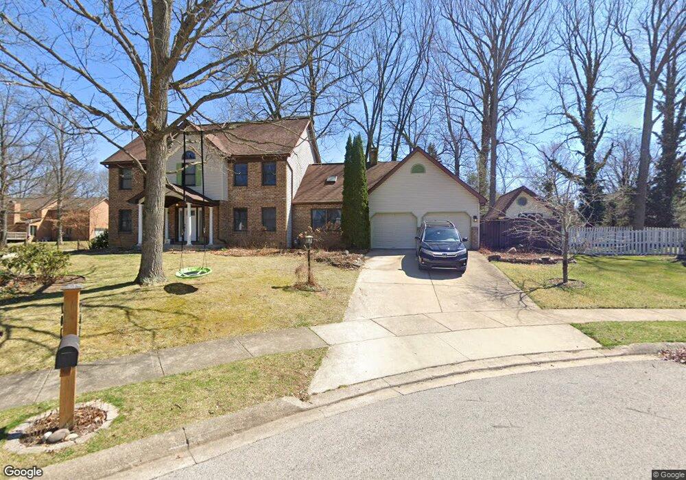
312 Canterbury Dr State College, PA 16803
Patton NeighborhoodEstimated Value: $527,000 - $541,000
4
Beds
4
Baths
3,411
Sq Ft
$156/Sq Ft
Est. Value
About This Home
This home is located at 312 Canterbury Dr, State College, PA 16803 and is currently estimated at $530,978, approximately $155 per square foot. 312 Canterbury Dr is a home located in Centre County with nearby schools including Park Forest Elementary School, Park Forest Middle School, and State College Area High School.
Ownership History
Date
Name
Owned For
Owner Type
Purchase Details
Closed on
Jun 29, 2011
Sold by
Clinger Stephen D and Clinger Karen S
Bought by
Brooks Richard M and Brooks Deborah A
Current Estimated Value
Home Financials for this Owner
Home Financials are based on the most recent Mortgage that was taken out on this home.
Original Mortgage
$294,750
Outstanding Balance
$203,829
Interest Rate
4.62%
Mortgage Type
New Conventional
Estimated Equity
$327,149
Purchase Details
Closed on
Jan 28, 1991
Bought by
Clinger Stephen D and Clinger Karen S
Create a Home Valuation Report for This Property
The Home Valuation Report is an in-depth analysis detailing your home's value as well as a comparison with similar homes in the area
Home Values in the Area
Average Home Value in this Area
Purchase History
| Date | Buyer | Sale Price | Title Company |
|---|---|---|---|
| Brooks Richard M | $327,500 | None Available | |
| Clinger Stephen D | $35,500 | -- |
Source: Public Records
Mortgage History
| Date | Status | Borrower | Loan Amount |
|---|---|---|---|
| Open | Brooks Richard M | $294,750 |
Source: Public Records
Tax History Compared to Growth
Tax History
| Year | Tax Paid | Tax Assessment Tax Assessment Total Assessment is a certain percentage of the fair market value that is determined by local assessors to be the total taxable value of land and additions on the property. | Land | Improvement |
|---|---|---|---|---|
| 2025 | $6,516 | $93,530 | $23,445 | $70,085 |
| 2024 | $6,078 | $93,530 | $23,445 | $70,085 |
| 2023 | $6,078 | $93,530 | $23,445 | $70,085 |
| 2022 | $5,932 | $93,530 | $23,445 | $70,085 |
| 2021 | $5,932 | $93,530 | $23,445 | $70,085 |
| 2020 | $5,932 | $93,530 | $23,445 | $70,085 |
| 2019 | $4,202 | $93,530 | $23,445 | $70,085 |
| 2018 | $5,751 | $93,530 | $23,445 | $70,085 |
| 2017 | $5,688 | $93,530 | $23,445 | $70,085 |
| 2016 | -- | $93,530 | $23,445 | $70,085 |
| 2015 | -- | $93,530 | $23,445 | $70,085 |
| 2014 | -- | $112,920 | $23,445 | $89,475 |
Source: Public Records
Map
Nearby Homes
- 291 Oakley Dr
- 169 Sandy Ridge Rd
- 479 Westgate Dr
- 2251 Red Oak Ln
- 835 Galen Dr Unit 835
- 833 Galen Dr
- 2292 Oak Leaf Dr
- 1765 Cambridge Dr
- 1635 Princeton Dr
- 1111-C W Aaron Dr
- 3182 Carnegie Dr
- 1832 Waddle Rd
- 1836 Waddle Rd
- 253 Bolton Ave
- 1383 N Allen St
- 257 Oakwood Ave
- 95 Greenmeadow Ln
- 1457 Curtin St
- 112 Montauk Cir
- 991 Scotia Rd
- 345 Oakley Dr
- 207 Teaberry Cir
- 351 Oakley Dr
- 307 Canterbury Dr
- 202 Teaberry Cir
- 339 Oakley Dr
- 357 Oakley Dr
- 313 Canterbury Dr
- 213 Teaberry Cir
- 208 Teaberry Cir
- 333 Oakley Dr
- 363 Oakley Dr
- 319 Canterbury Dr
- 402 Candlewood Dr
- 404 Candlewood Dr
- 234 Canterbury Dr
- 314 Oakley Dr
- 327 Oakley Dr
- 369 Oakley Dr
- 605 Severn Dr