
Seller's Agent in 2026
Amy Hill
EXP Realty LLC
(360) 790-7234
17 in this area
66 Total Sales
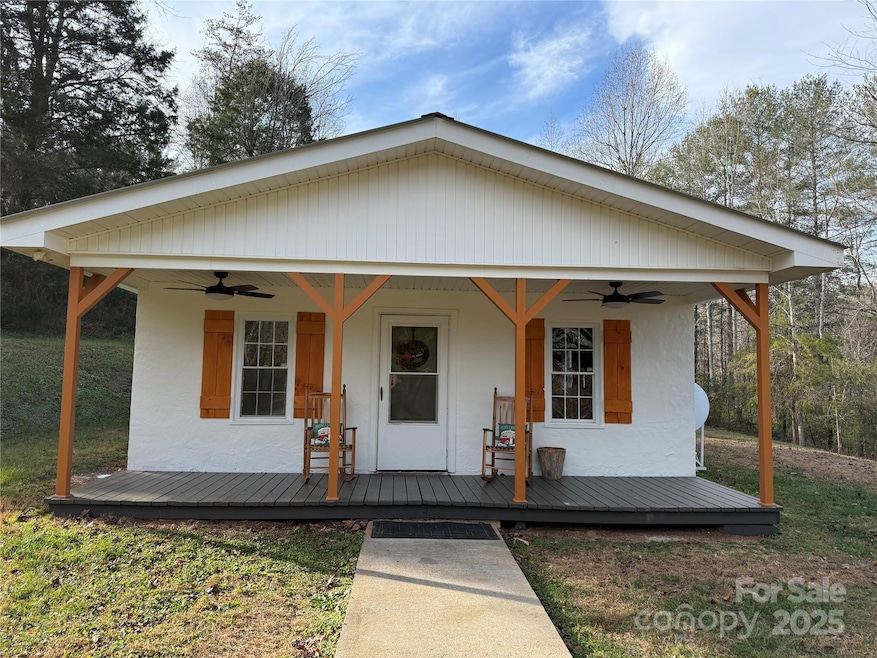


Your cozy retreat awaits! This charming 2 bedroom, 1 bath home is a peaceful haven. Wood ceilings throughout the majority of the home set a soothing atmosphere, complemented by updated fixtures throughout. Enjoy the serene surroundings on your quiet, semi private lot where deer and other wildlife visit often. Nature lovers will enjoy relaxing by the fire pit in the backyard, storing gear in the storage shed/workshop, and parking toys or equipment under the attached lean to. Don't wait to schedule your showing. Your peaceful retreat awaits!
Last Agent to Sell the Property
EXP Realty LLC Brokerage Email: amyhillhomes@gmail.com License #281984 Listed on: 11/25/2025
| Date | Type | Sale Price | Title Company |
|---|---|---|---|
| Warranty Deed | -- | None Listed On Document | |
| Warranty Deed | -- | None Listed On Document | |
| Warranty Deed | $39,000 | None Available |
| Date | Status | Loan Amount | Loan Type |
|---|---|---|---|
| Previous Owner | $40,000 | New Conventional |
| Date | Event | Price | List to Sale | Price per Sq Ft |
|---|---|---|---|---|
| 03/20/2026 03/20/26 | Sold | $190,000 | -5.0% | $247 / Sq Ft |
| 11/25/2025 11/25/25 | For Sale | $199,900 | -- | $260 / Sq Ft |
| Year | Tax Paid | Tax Assessment Tax Assessment Total Assessment is a certain percentage of the fair market value that is determined by local assessors to be the total taxable value of land and additions on the property. | Land | Improvement |
|---|---|---|---|---|
| 2025 | $282 | $33,283 | $13,891 | $19,392 |
| 2024 | $279 | $33,283 | $13,891 | $19,392 |
| 2023 | $274 | $33,283 | $13,891 | $19,392 |
| 2022 | $271 | $27,237 | $9,600 | $17,637 |
| 2021 | $265 | $27,237 | $9,600 | $17,637 |
| 2020 | $261 | $27,237 | $9,600 | $17,637 |
| 2019 | $261 | $27,237 | $9,600 | $17,637 |
| 2018 | $260 | $27,108 | $9,600 | $17,508 |
| 2017 | $258 | $27,108 | $9,600 | $17,508 |
| 2016 | $249 | $27,108 | $9,600 | $17,508 |
| 2015 | $246 | $27,108 | $9,600 | $17,508 |
| 2014 | $245 | $27,108 | $9,600 | $17,508 |
| 2013 | $245 | $27,108 | $9,600 | $17,508 |
Seller's Agent in 2026
Amy Hill
EXP Realty LLC
(360) 790-7234
17 in this area
66 Total Sales
M
Buyer's Agent in 2026
Madeline Pollard
Chase Gray Realty LLC
(828) 448-8918
4 in this area
33 Total Sales
Source: Canopy MLS (Canopy Realtor® Association)
MLS Number: 4325154
APN: 40539
Disclaimer: Certain information contained herein is derived from information provided by parties other than Homes.com. All information provided is deemed reliable, but is not guaranteed to be accurate and should be independently verified.
![]() All data is obtained from various sources and may not have been verified by broker or MLS GRID. Supplied Open House Information is subject to change without notice. All information should be independently reviewed and verified for accuracy. Properties may or may not be listed by the office/agent presenting the information. Some IDX listings have been excluded from this website.
All data is obtained from various sources and may not have been verified by broker or MLS GRID. Supplied Open House Information is subject to change without notice. All information should be independently reviewed and verified for accuracy. Properties may or may not be listed by the office/agent presenting the information. Some IDX listings have been excluded from this website.
Based on information submitted to the MLS GRID
Ask me questions while you tour the home.