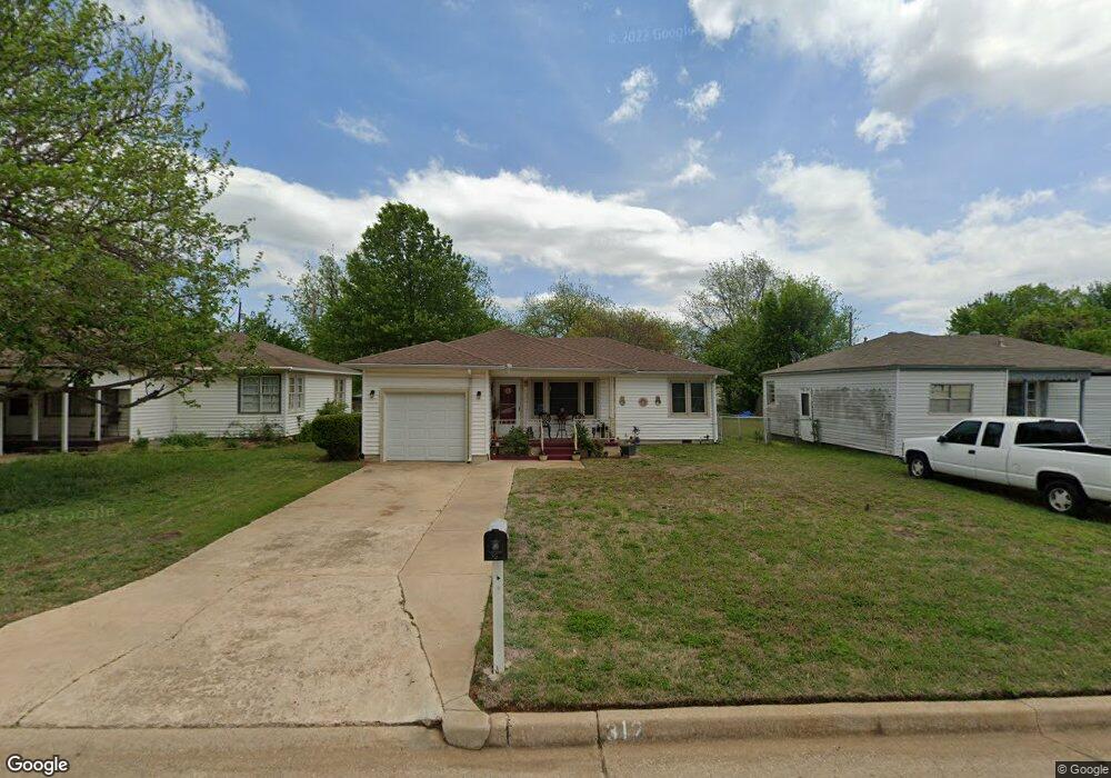
312 N G St Duncan, OK 73533
Estimated Value: $57,084 - $71,000
2
Beds
1
Bath
988
Sq Ft
$64/Sq Ft
Est. Value
About This Home
This home is located at 312 N G St, Duncan, OK 73533 and is currently estimated at $62,771, approximately $63 per square foot. 312 N G St is a home located in Stephens County with nearby schools including Woodrow Wilson Elementary School, Duncan Middle School, and Duncan High School.
Ownership History
Date
Name
Owned For
Owner Type
Purchase Details
Closed on
Sep 16, 2019
Sold by
Bryce Laura Clydene
Bought by
Price Martha
Current Estimated Value
Purchase Details
Closed on
Aug 11, 2015
Sold by
Hadley Carolyn
Bought by
Bryce Laura Clydene
Home Financials for this Owner
Home Financials are based on the most recent Mortgage that was taken out on this home.
Original Mortgage
$45,630
Interest Rate
4.13%
Mortgage Type
Future Advance Clause Open End Mortgage
Purchase Details
Closed on
May 10, 2004
Sold by
Murray Karen
Bought by
Hadley Donald R and Hadley Carolyn
Purchase Details
Closed on
Apr 27, 2004
Sold by
Murray Wanda L
Purchase Details
Closed on
Sep 18, 2001
Sold by
Murray Wanda
Purchase Details
Closed on
Sep 11, 2001
Sold by
Murray Lawrence and Murray Wanda
Create a Home Valuation Report for This Property
The Home Valuation Report is an in-depth analysis detailing your home's value as well as a comparison with similar homes in the area
Home Values in the Area
Average Home Value in this Area
Purchase History
| Date | Buyer | Sale Price | Title Company |
|---|---|---|---|
| Price Martha | $42,500 | Stephens Co Abstract Co | |
| Bryce Laura Clydene | $425,000 | None Available | |
| Hadley Donald R | $32,000 | -- | |
| -- | -- | -- | |
| -- | -- | -- | |
| -- | -- | -- |
Source: Public Records
Mortgage History
| Date | Status | Borrower | Loan Amount |
|---|---|---|---|
| Previous Owner | Bryce Laura Clydene | $45,630 |
Source: Public Records
Tax History Compared to Growth
Tax History
| Year | Tax Paid | Tax Assessment Tax Assessment Total Assessment is a certain percentage of the fair market value that is determined by local assessors to be the total taxable value of land and additions on the property. | Land | Improvement |
|---|---|---|---|---|
| 2025 | $310 | $4,778 | $341 | $4,437 |
| 2024 | $310 | $4,638 | $341 | $4,297 |
| 2023 | $310 | $4,503 | $341 | $4,162 |
| 2022 | $300 | $4,531 | $341 | $4,190 |
| 2021 | $354 | $5,165 | $341 | $4,824 |
| 2020 | $334 | $4,868 | $341 | $4,527 |
| 2019 | $408 | $4,716 | $341 | $4,375 |
| 2018 | $400 | $4,491 | $341 | $4,150 |
| 2017 | $404 | $4,698 | $341 | $4,357 |
| 2016 | $431 | $5,073 | $341 | $4,732 |
| 2015 | $272 | $4,101 | $275 | $3,826 |
| 2014 | $272 | $4,101 | $295 | $3,806 |
Source: Public Records
Map
Nearby Homes