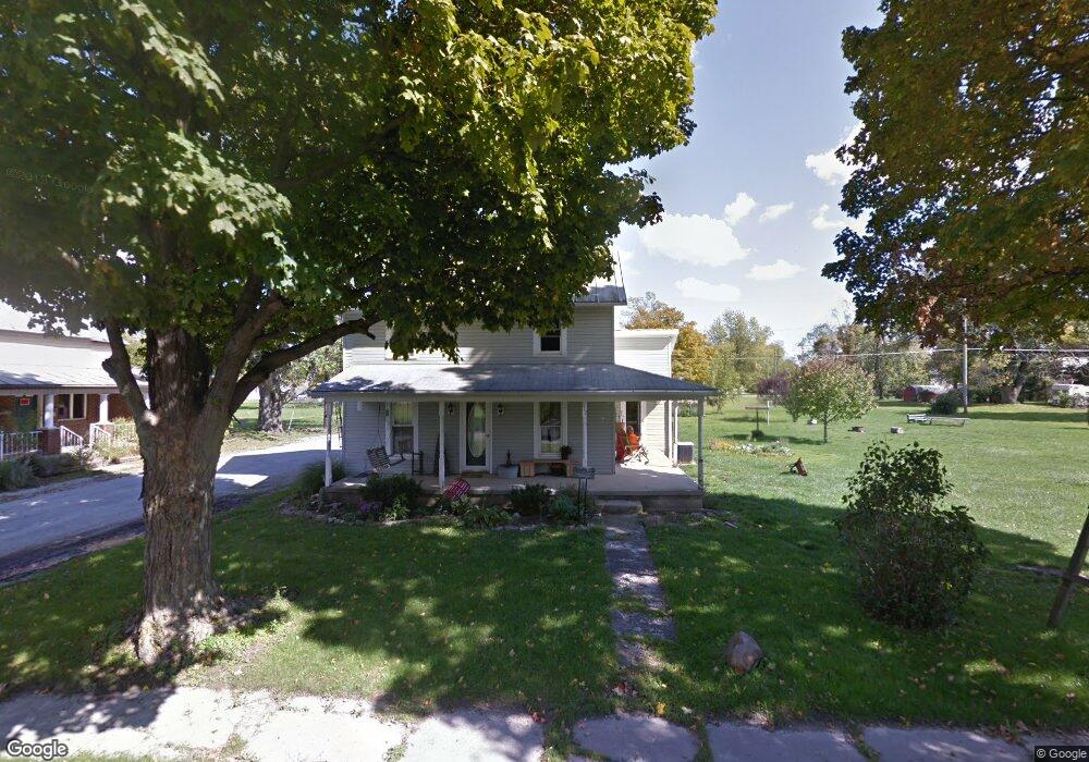
312 N Martin St Forest, OH 45843
Estimated Value: $141,000 - $171,000
3
Beds
1
Bath
1,320
Sq Ft
$118/Sq Ft
Est. Value
About This Home
This home is located at 312 N Martin St, Forest, OH 45843 and is currently estimated at $155,131, approximately $117 per square foot. 312 N Martin St is a home located in Hardin County with nearby schools including Riverdale Middle School and Riverdale High School.
Ownership History
Date
Name
Owned For
Owner Type
Purchase Details
Closed on
May 6, 1998
Bought by
Rowe Darrin E and Rowe Vicki J
Current Estimated Value
Purchase Details
Closed on
Jan 27, 1995
Bought by
Morris Bonnie S Trustee
Purchase Details
Closed on
Sep 14, 1993
Bought by
Morris Bonnie Sue
Purchase Details
Closed on
Nov 25, 1991
Purchase Details
Closed on
Aug 27, 1987
Create a Home Valuation Report for This Property
The Home Valuation Report is an in-depth analysis detailing your home's value as well as a comparison with similar homes in the area
Home Values in the Area
Average Home Value in this Area
Purchase History
| Date | Buyer | Sale Price | Title Company |
|---|---|---|---|
| Rowe Darrin E | $26,500 | -- | |
| Morris Bonnie S Trustee | -- | -- | |
| Morris Bonnie Sue | $200 | -- | |
| -- | $20,000 | -- | |
| -- | -- | -- |
Source: Public Records
Tax History Compared to Growth
Tax History
| Year | Tax Paid | Tax Assessment Tax Assessment Total Assessment is a certain percentage of the fair market value that is determined by local assessors to be the total taxable value of land and additions on the property. | Land | Improvement |
|---|---|---|---|---|
| 2024 | $1,079 | $33,770 | $3,920 | $29,850 |
| 2023 | $1,079 | $33,770 | $3,920 | $29,850 |
| 2022 | $966 | $26,460 | $3,600 | $22,860 |
| 2021 | $1,046 | $26,460 | $3,600 | $22,860 |
| 2020 | $1,049 | $26,460 | $3,600 | $22,860 |
| 2019 | $825 | $21,190 | $3,430 | $17,760 |
| 2018 | $792 | $21,190 | $3,430 | $17,760 |
| 2017 | $778 | $21,190 | $3,430 | $17,760 |
| 2016 | $767 | $19,690 | $4,020 | $15,670 |
| 2015 | $679 | $19,690 | $4,020 | $15,670 |
| 2014 | $707 | $19,690 | $4,020 | $15,670 |
| 2013 | $684 | $19,690 | $4,020 | $15,670 |
Source: Public Records
Map
Nearby Homes
- 402 E Lima St
- 0 S Davis St
- 412 E Lima St
- 412 S Patterson St
- 0 S Patterson St
- 615 W Gage St
- 18660 County Road 20
- 0 Cr 215 Unit 11594771
- 0 Cr 215 Unit 11594600
- 0 Cr 215 Unit 25370311
- 0 Cr 215 Unit 11598074
- 3065 County Road 205
- 15418 Ohio 37
- 5091 County Road 175
- 20453 Township Road 187
- 4771 County Road 159
- 6497 County Highway 87
- 12443 Township Road 20
- 420 N Main St
- 1568 State Route 68