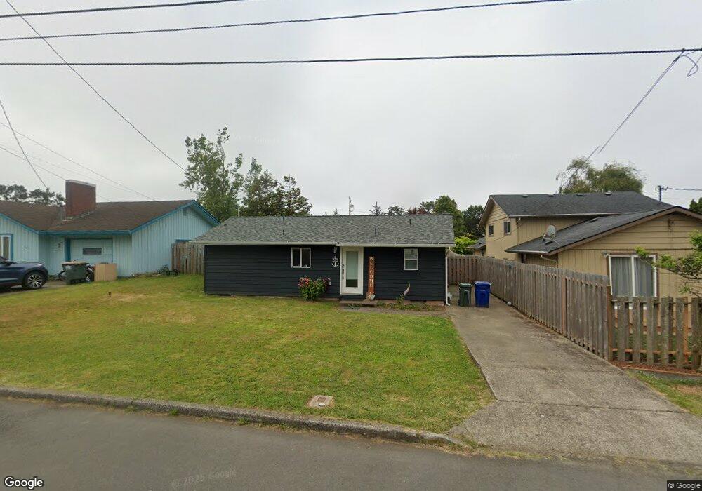
312 NE 12th St Newport, OR 97365
Estimated Value: $339,000 - $383,000
3
Beds
1
Bath
864
Sq Ft
$408/Sq Ft
Est. Value
About This Home
This home is located at 312 NE 12th St, Newport, OR 97365 and is currently estimated at $352,512, approximately $408 per square foot. 312 NE 12th St is a home located in Lincoln County with nearby schools including Sam Case Elementary School, Yaquina View Elementary School, and Newport High School.
Ownership History
Date
Name
Owned For
Owner Type
Purchase Details
Closed on
Dec 27, 2021
Sold by
Jacobson Robret W
Bought by
Jincks Sarah Ann
Current Estimated Value
Home Financials for this Owner
Home Financials are based on the most recent Mortgage that was taken out on this home.
Original Mortgage
$275,500
Outstanding Balance
$252,344
Interest Rate
3.11%
Mortgage Type
Commercial
Estimated Equity
$100,168
Purchase Details
Closed on
Apr 30, 2021
Sold by
Beemer Richard K and Beemer Family Trust
Bought by
Jacobson Robert W
Create a Home Valuation Report for This Property
The Home Valuation Report is an in-depth analysis detailing your home's value as well as a comparison with similar homes in the area
Home Values in the Area
Average Home Value in this Area
Purchase History
| Date | Buyer | Sale Price | Title Company |
|---|---|---|---|
| Jincks Sarah Ann | $276,500 | Western Title & Escrow | |
| Jacobson Robert W | $135,000 | Western Title & Escrow |
Source: Public Records
Mortgage History
| Date | Status | Borrower | Loan Amount |
|---|---|---|---|
| Open | Jincks Sarah Ann | $275,500 |
Source: Public Records
Tax History Compared to Growth
Tax History
| Year | Tax Paid | Tax Assessment Tax Assessment Total Assessment is a certain percentage of the fair market value that is determined by local assessors to be the total taxable value of land and additions on the property. | Land | Improvement |
|---|---|---|---|---|
| 2025 | $2,778 | $155,280 | -- | -- |
| 2024 | $2,720 | $150,760 | -- | -- |
| 2023 | $2,656 | $146,370 | $0 | $0 |
| 2022 | $2,575 | $142,110 | $0 | $0 |
| 2021 | $2,420 | $131,990 | $0 | $0 |
| 2020 | $2,363 | $128,150 | $0 | $0 |
| 2019 | $2,262 | $124,420 | $0 | $0 |
| 2018 | $2,192 | $120,800 | $0 | $0 |
| 2017 | $2,173 | $117,290 | $0 | $0 |
| 2016 | $2,127 | $113,880 | $0 | $0 |
| 2015 | $1,972 | $110,570 | $0 | $0 |
| 2014 | $1,928 | $107,350 | $0 | $0 |
| 2013 | -- | $104,230 | $0 | $0 |
Source: Public Records
Map
Nearby Homes
- 1061 NE Douglas St
- 240 NE 10th Ct
- 230 NE 10th Ct
- 217 NE Chambers Ct
- 433 NE 8th St
- 000 NW Grove St
- 328 NE San-Bay-o Cir
- 166 NE 8th St
- 1620 NW Nye St
- 321 NE 4th St
- 252 NW 18th St
- 1725 NW Oceanview Dr
- 247 N Coast Hwy
- 929 NW Spring St
- 237 N Coast Hwy
- 248 N Coast Hwy
- 252 NW 20th St
- Lot8 Crown Crest Nw 19th St
- 546 NE 3rd St
- 184 N Coast Hwy
- 1134 NE Benton St
- 330 NE 12th St
- 210 NE 12th St
- 315 NE 11th St
- 303 NE 11th St
- 1400 Benton (T L) St
- 325 NE 11th St
- 335 NE 11th St
- 266 NE 12th St
- 1210 NE Benton St
- 267 NE 11th St
- 316 NE 11th St
- 255 NE 11th St
- 1228 NE Benton St
- 326 NE 11th St
- 242 NE 12th St
- 1078 NE Benton St
- 245 NE 11th St
- 1240 NE Benton St
- 350 NE 11th St