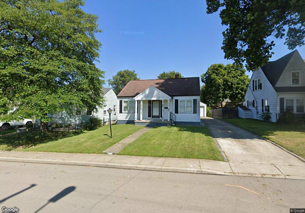
312 Probasco St Greendale, IN 47025
Estimated Value: $181,000 - $218,000
2
Beds
1
Bath
780
Sq Ft
$265/Sq Ft
Est. Value
About This Home
This home is located at 312 Probasco St, Greendale, IN 47025 and is currently estimated at $206,452, approximately $264 per square foot. 312 Probasco St is a home located in Dearborn County with nearby schools including Lawrenceburg Primary School, Central Elementary School, and Greendale Middle School.
Ownership History
Date
Name
Owned For
Owner Type
Purchase Details
Closed on
Nov 23, 2011
Sold by
Robinson Carol Lee and Robinson Gene A
Bought by
Seymour Keith M
Current Estimated Value
Home Financials for this Owner
Home Financials are based on the most recent Mortgage that was taken out on this home.
Original Mortgage
$85,000
Outstanding Balance
$58,213
Interest Rate
4.11%
Mortgage Type
New Conventional
Estimated Equity
$148,239
Purchase Details
Closed on
Jun 7, 2006
Sold by
Robinson Carol L
Bought by
Robinson Carol Lee and Robinson Gene A
Create a Home Valuation Report for This Property
The Home Valuation Report is an in-depth analysis detailing your home's value as well as a comparison with similar homes in the area
Home Values in the Area
Average Home Value in this Area
Purchase History
| Date | Buyer | Sale Price | Title Company |
|---|---|---|---|
| Seymour Keith M | -- | -- | |
| Robinson Carol Lee | -- | -- |
Source: Public Records
Mortgage History
| Date | Status | Borrower | Loan Amount |
|---|---|---|---|
| Open | Seymour Keith M | $85,000 |
Source: Public Records
Tax History Compared to Growth
Tax History
| Year | Tax Paid | Tax Assessment Tax Assessment Total Assessment is a certain percentage of the fair market value that is determined by local assessors to be the total taxable value of land and additions on the property. | Land | Improvement |
|---|---|---|---|---|
| 2024 | $1,424 | $142,400 | $19,600 | $122,800 |
| 2023 | $1,312 | $131,200 | $19,600 | $111,600 |
| 2022 | $1,231 | $123,100 | $19,600 | $103,500 |
| 2021 | $1,170 | $117,000 | $19,600 | $97,400 |
| 2020 | $1,163 | $116,300 | $19,600 | $96,700 |
| 2019 | $1,093 | $109,300 | $19,600 | $89,700 |
| 2018 | $939 | $99,100 | $19,600 | $79,500 |
| 2017 | $757 | $88,400 | $19,600 | $68,800 |
| 2016 | $753 | $88,400 | $19,600 | $68,800 |
| 2014 | $633 | $85,100 | $19,600 | $65,500 |
Source: Public Records
Map
Nearby Homes
- 497 Sheldon St
- 235 Tebbs Ave
- 520 Sheldon St
- 151 Brown St
- 122 Billups Dr
- 887 Nowlin Ave
- 0 Sunset Dr Unit 204596
- 0 Sunset Dr Unit 1856832
- 0 Sunset Dr Unit MBR22065196
- 130 Parkside Ave
- 614 River Ridge
- 0 Crossbow Trail Unit 204758
- 939 Nowlin Ave
- 60 Dearborn Ct
- 204 E Wind Ln
- 952 Miller Ave
- 219 Parkgrove Ave
- 46 Parkside Ave
- 302 Sunset View
- 10 Dearborn Ct