Estimated Value: $369,000 - $468,731
4
Beds
3
Baths
4,171
Sq Ft
$98/Sq Ft
Est. Value
About This Home
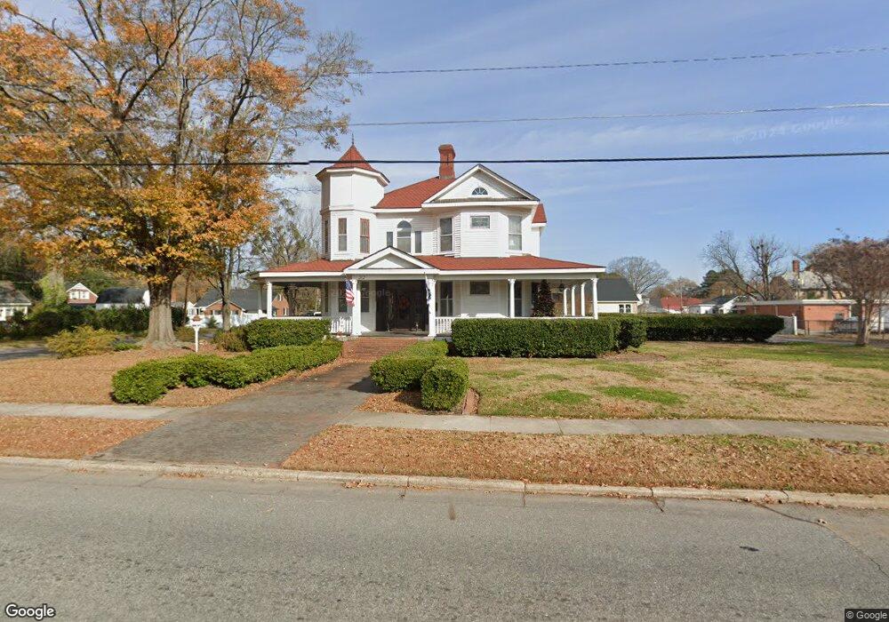
This home is located at 312 W Anderson St, Selma, NC 27576 and is currently estimated at $410,683, approximately $98 per square foot. 312 W Anderson St is a home located in Johnston County with nearby schools including Selma Elementary School, Selma Middle School, and Smithfield-Selma High School.
Ownership History
Date
Name
Owned For
Owner Type
Purchase Details
Closed on
Aug 27, 2016
Sold by
Howard Paul H and Edwards Howard Debbie
Bought by
Mcallister Sara and Mcallister Byron
Current Estimated Value
Home Financials for this Owner
Home Financials are based on the most recent Mortgage that was taken out on this home.
Original Mortgage
$193,325
Interest Rate
4.25%
Mortgage Type
FHA
Create a Home Valuation Report for This Property
The Home Valuation Report is an in-depth analysis detailing your home's value as well as a comparison with similar homes in the area
Home Values in the Area
Average Home Value in this Area
Purchase History
| Date | Buyer | Sale Price | Title Company |
|---|---|---|---|
| Mcallister Sara | $170,000 | None Available | |
| Howard Paul H | -- | None Available |
Source: Public Records
Mortgage History
| Date | Status | Borrower | Loan Amount |
|---|---|---|---|
| Previous Owner | Mcallister Sara | $193,325 |
Source: Public Records
Tax History
| Year | Tax Paid | Tax Assessment Tax Assessment Total Assessment is a certain percentage of the fair market value that is determined by local assessors to be the total taxable value of land and additions on the property. | Land | Improvement |
|---|---|---|---|---|
| 2025 | $4,470 | $399,070 | $87,500 | $311,570 |
| 2024 | $3,509 | $276,280 | $43,750 | $232,530 |
| 2023 | $3,564 | $276,280 | $43,750 | $232,530 |
| 2022 | $3,675 | $276,280 | $43,750 | $232,530 |
| 2021 | $3,619 | $276,280 | $43,750 | $232,530 |
| 2020 | $3,675 | $276,280 | $43,750 | $232,530 |
| 2019 | $3,592 | $276,280 | $43,750 | $232,530 |
| 2018 | $3,566 | $270,170 | $33,370 | $236,800 |
| 2017 | $2,185 | $169,380 | $33,370 | $136,010 |
| 2016 | $2,187 | $169,550 | $33,540 | $136,010 |
| 2015 | $2,187 | $169,550 | $33,540 | $136,010 |
| 2014 | $2,187 | $169,550 | $33,540 | $136,010 |
Source: Public Records
Map
Nearby Homes
- 201 N Massey St
- 0 Atkinson Mill Rd Unit 10022797
- 5493 N Carolina 39 Hwy
- 404 N Massey St
- 183 Noramac Ct
- 301 N Brevard St
- 208 S Webb St
- 206 S Ethel St
- 303 Graves St
- 406 N Webb St
- 812 W Anderson St
- 208 S Ethel St
- 601 W Walnut St
- 408 S Brevard St
- 903 W Anderson St Unit 1/2
- 00 S Ethel St
- 406 E Waddell St Unit B
- 807 N Pollock St
- 62 W Victoria Ridge Dr W Unit 19
- 207 E Griswold St
- 311 W Waddell St
- 402 W Anderson St
- 311 W Anderson St
- 401 W Waddell St
- 404 W Anderson St
- 102 S Massey St
- 111 N Massey St
- 403 W Waddell St
- 200 N Sumner St
- 105 S Sumner St
- 406 W Anderson St
- 106 S Massey St
- 308 W Waddell St
- 304 W Waddell St
- 406 West St
- 405 W Waddell St
- 112 N Massey St
- 112 N Massey St
- 212 W Anderson St
- 112 S Massey St
Your Personal Tour Guide
Ask me questions while you tour the home.