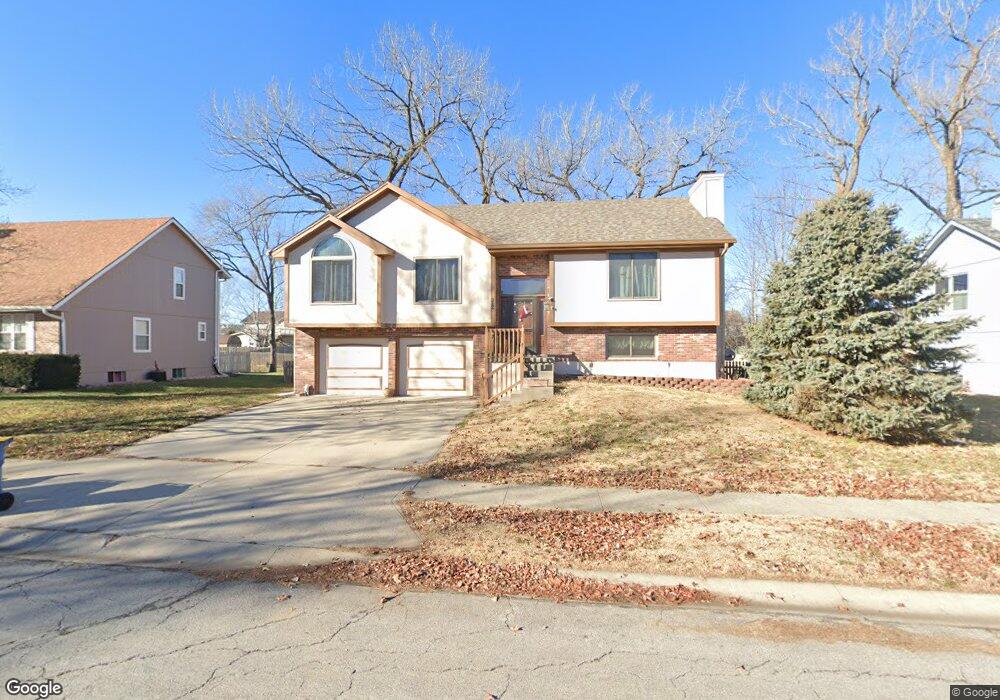
312 Wildflower Ln Kearney, MO 64060
Estimated Value: $301,000 - $323,000
3
Beds
2
Baths
1,319
Sq Ft
$236/Sq Ft
Est. Value
About This Home
This home is located at 312 Wildflower Ln, Kearney, MO 64060 and is currently estimated at $310,688, approximately $235 per square foot. 312 Wildflower Ln is a home located in Clay County with nearby schools including Kearney Junior High School and Kearney High School.
Ownership History
Date
Name
Owned For
Owner Type
Purchase Details
Closed on
Mar 21, 2006
Sold by
Ray David W and Ray Debra L
Bought by
Parshall Richard B and Parshall Sherie A
Current Estimated Value
Home Financials for this Owner
Home Financials are based on the most recent Mortgage that was taken out on this home.
Original Mortgage
$135,755
Outstanding Balance
$76,904
Interest Rate
6.21%
Mortgage Type
Fannie Mae Freddie Mac
Estimated Equity
$233,784
Purchase Details
Closed on
Dec 16, 1999
Sold by
Hud
Bought by
Ray David William and Ray Debra Lynn
Home Financials for this Owner
Home Financials are based on the most recent Mortgage that was taken out on this home.
Original Mortgage
$99,875
Interest Rate
7.71%
Purchase Details
Closed on
Sep 15, 1999
Sold by
Bank United
Bought by
Hud
Purchase Details
Closed on
Jun 18, 1999
Sold by
Unruh Ronald B and Unruh Brenda K
Bought by
Bank United
Create a Home Valuation Report for This Property
The Home Valuation Report is an in-depth analysis detailing your home's value as well as a comparison with similar homes in the area
Home Values in the Area
Average Home Value in this Area
Purchase History
| Date | Buyer | Sale Price | Title Company |
|---|---|---|---|
| Parshall Richard B | -- | Community Land Title | |
| Ray David William | -- | -- | |
| Hud | -- | First American Title | |
| Bank United | $106,496 | -- |
Source: Public Records
Mortgage History
| Date | Status | Borrower | Loan Amount |
|---|---|---|---|
| Open | Parshall Richard B | $135,755 | |
| Previous Owner | Ray David William | $99,875 |
Source: Public Records
Tax History Compared to Growth
Tax History
| Year | Tax Paid | Tax Assessment Tax Assessment Total Assessment is a certain percentage of the fair market value that is determined by local assessors to be the total taxable value of land and additions on the property. | Land | Improvement |
|---|---|---|---|---|
| 2025 | $2,440 | $40,910 | -- | -- |
| 2024 | $2,440 | $35,610 | -- | -- |
| 2023 | $2,432 | $35,610 | $0 | $0 |
| 2022 | $2,226 | $31,520 | $0 | $0 |
| 2021 | $2,182 | $31,521 | $3,800 | $27,721 |
| 2020 | $2,156 | $28,330 | $0 | $0 |
| 2019 | $2,145 | $28,329 | $3,800 | $24,529 |
| 2018 | $2,125 | $27,110 | $0 | $0 |
| 2017 | $2,029 | $27,110 | $3,800 | $23,310 |
| 2016 | $2,029 | $26,160 | $3,800 | $22,360 |
| 2015 | $2,029 | $26,160 | $3,800 | $22,360 |
| 2014 | $1,981 | $25,420 | $4,180 | $21,240 |
Source: Public Records
Map
Nearby Homes
- 2212 Blue Bell Terrace
- 417 Wildflower Ln
- 210 E 22nd St
- 2211 Prairie Creek Dr
- 2341 Fishing Ln
- 2129 Greenfield Point Unit 20
- 2119 Greenfield Point
- 2125 Greenfield Point
- 2123 Greenfield Point
- 2121 Greenfield Point
- 2333 Fishing Ln
- 2304 Foxtail Dr
- 2309 Fishing Ln
- 2059 Foxtail Point
- Charleston Plan at The Meadows At Greenfield - The Meadows at Greenfield
- Oakwood Plan at The Meadows At Greenfield - The Meadows at Greenfield
- Villa B Plan at The Meadows At Greenfield - The Meadows at Greenfield
- Chestnut Plan at The Meadows At Greenfield - Meadows At Greenfield
- McKinley Plan at The Meadows At Greenfield - Meadows At Greenfield
- Brookside Plan at The Meadows At Greenfield - The Meadows at Greenfield
- 310 Wildflower Ln
- 314 Wildflower Ln
- 311 Wildflower Ln
- 400 Wildflower Ln
- 308 Wildflower Ln
- 313 Wildflower Ln
- 309 Wildflower Ln
- 311 Meadowbrook Dr
- 401 Wildflower Ln
- 313 Meadowbrook Dr
- 309 Meadowbrook Dr
- 402 Wildflower Ln
- 306 Wildflower Ln
- 401 Meadowbrook Dr
- 307 Meadowbrook Dr
- 312 Evening Star Dr
- 403 Wildflower Ln
- 314 Evening Star Dr
- 310 Evening Star Dr
- 316 Evening Star Dr