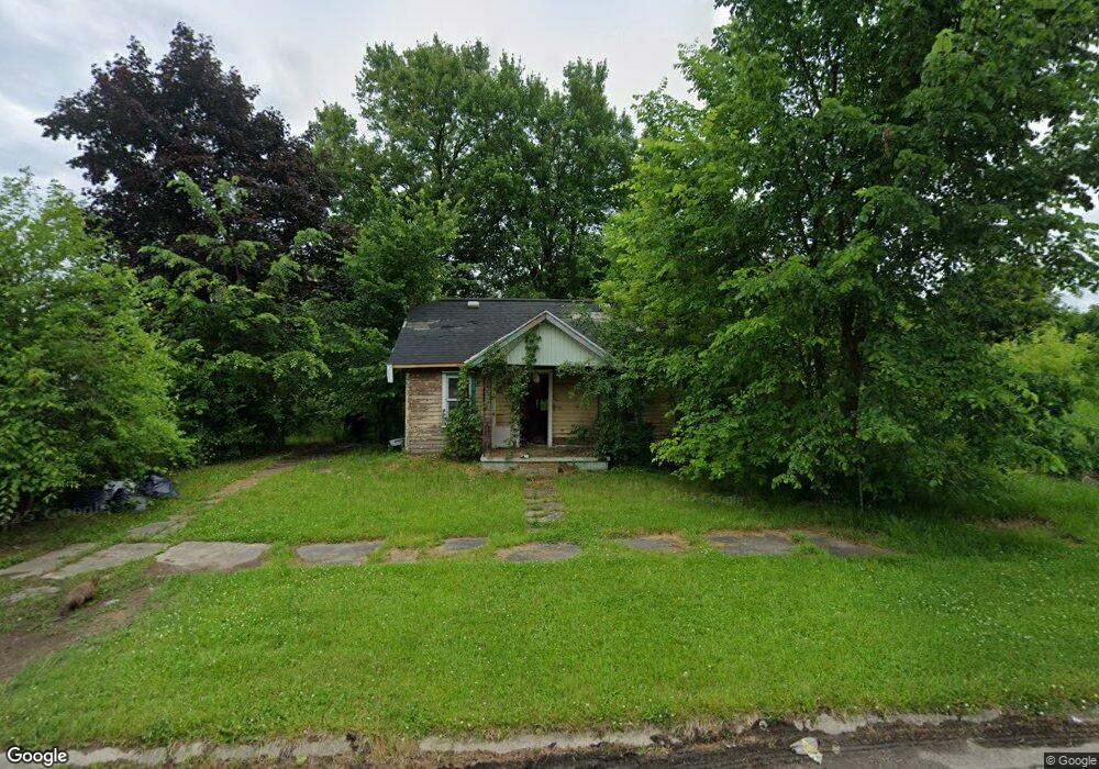
3120 Risedorph Ave Flint, MI 48506
Potter Longway NeighborhoodEstimated Value: $36,000 - $45,000
1
Bed
1
Bath
720
Sq Ft
$55/Sq Ft
Est. Value
About This Home
This home is located at 3120 Risedorph Ave, Flint, MI 48506 and is currently estimated at $39,607, approximately $55 per square foot. 3120 Risedorph Ave is a home located in Genesee County with nearby schools including Potter School, Richfield Public School Academy, and Richfield Early Learning Center.
Ownership History
Date
Name
Owned For
Owner Type
Purchase Details
Closed on
Dec 20, 2017
Sold by
Cherry Deborah L and The Genesee County Treasurer
Bought by
Genesee County Land Bank Authority
Current Estimated Value
Purchase Details
Closed on
Feb 7, 2005
Sold by
Hayes William S and Hayes Dorothy M
Bought by
Smith Richard W
Purchase Details
Closed on
Dec 3, 2004
Sold by
Smith Sean
Bought by
Hayes William S and Hayes Dorothy M
Purchase Details
Closed on
Mar 20, 2002
Sold by
Kendall Pamela S
Bought by
Smith Sean
Home Financials for this Owner
Home Financials are based on the most recent Mortgage that was taken out on this home.
Original Mortgage
$26,010
Interest Rate
11%
Mortgage Type
Seller Take Back
Create a Home Valuation Report for This Property
The Home Valuation Report is an in-depth analysis detailing your home's value as well as a comparison with similar homes in the area
Home Values in the Area
Average Home Value in this Area
Purchase History
| Date | Buyer | Sale Price | Title Company |
|---|---|---|---|
| Genesee County Land Bank Authority | -- | None Available | |
| Smith Richard W | -- | Guaranty Title Company | |
| Hayes William S | -- | Stewart Title Guaranty Co | |
| Smith Sean | $28,900 | First American Title Ins Co |
Source: Public Records
Mortgage History
| Date | Status | Borrower | Loan Amount |
|---|---|---|---|
| Previous Owner | Smith Sean | $26,010 |
Source: Public Records
Tax History
| Year | Tax Paid | Tax Assessment Tax Assessment Total Assessment is a certain percentage of the fair market value that is determined by local assessors to be the total taxable value of land and additions on the property. | Land | Improvement |
|---|---|---|---|---|
| 2025 | -- | $0 | $0 | $0 |
| 2024 | -- | $0 | $0 | $0 |
| 2023 | -- | $0 | $0 | $0 |
| 2022 | $0 | $0 | $0 | $0 |
| 2021 | $0 | $0 | $0 | $0 |
| 2020 | $0 | $0 | $0 | $0 |
| 2019 | $698 | $0 | $0 | $0 |
| 2018 | $221 | $0 | $0 | $0 |
| 2017 | $1,165 | $0 | $0 | $0 |
| 2016 | $698 | $0 | $0 | $0 |
| 2015 | -- | $0 | $0 | $0 |
| 2014 | -- | $0 | $0 | $0 |
| 2012 | -- | $9,400 | $0 | $0 |
Source: Public Records
Map
Nearby Homes
- 3149 Whittier Ave
- 3213 Holly Ave
- 2701 Branch Rd
- 2719 Branch Rd
- 2002 Branch Rd
- 3018 Dakota Ave
- 3232 Dale Ave
- 3314 Dakota Ave
- 2211 Torrance St
- 3413 Dakota Ave
- 2426 Hoff St
- 3614 Holly Ave
- 3602 Dakota Ave
- 2321 Levern St
- 3617 Davison Rd
- 2426 Broadway Blvd
- 3118 Wyoming Ave
- 3210 Wyoming Ave
- 3010 Wyoming Ave
- 3421 Brewster St
- 3116 Risedorph Ave
- 3132 Risedorph Ave
- 3128 Risedorph Ave
- 3119 Woodrow Ave
- 3115 Woodrow Ave
- 2408 Branch Rd
- 3119 Risedorph Ave
- 3131 Woodrow Ave
- 3115 Risedorph Ave
- 3136 Risedorph Ave
- 2420 Branch Rd
- 3127 Risedorph Ave
- 2402 Branch Rd
- 2502 Branch Rd
- 3140 Risedorph Ave
- 2514 Branch Rd
- 3135 Risedorph Ave
- 3133 Woodrow Ave
- 2508 Branch Rd
- 3144 Risedorph Ave
Your Personal Tour Guide
Ask me questions while you tour the home.