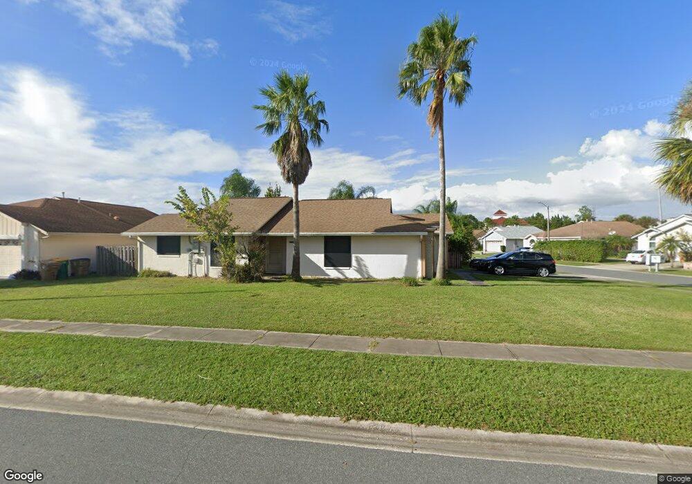
3120 Smoke Signal Cir Kissimmee, FL 34746
North Kissimmee NeighborhoodEstimated Value: $306,000 - $371,000
3
Beds
2
Baths
1,854
Sq Ft
$179/Sq Ft
Est. Value
About This Home
This home is located at 3120 Smoke Signal Cir, Kissimmee, FL 34746 and is currently estimated at $332,670, approximately $179 per square foot. 3120 Smoke Signal Cir is a home located in Osceola County with nearby schools including Reedy Creek Elementary School, Kissimmee Middle School, and Celebration High School.
Ownership History
Date
Name
Owned For
Owner Type
Purchase Details
Closed on
Jul 21, 2025
Sold by
Covelli Paul Ronald and Covelli Pamela Ann
Bought by
Covelli Pamela Ann and Covelli Family Living Trust
Current Estimated Value
Purchase Details
Closed on
Aug 10, 2001
Sold by
Mceuen Larry and Mceuen Joanne
Bought by
Covelli Paul R and Covelli Pamela A
Home Financials for this Owner
Home Financials are based on the most recent Mortgage that was taken out on this home.
Original Mortgage
$52,000
Interest Rate
7.19%
Purchase Details
Closed on
Oct 2, 1998
Sold by
Glas Armando C and Deglas Daisy
Bought by
Mceuen Larry and Mceuen Joanne
Home Financials for this Owner
Home Financials are based on the most recent Mortgage that was taken out on this home.
Original Mortgage
$82,800
Interest Rate
6.8%
Create a Home Valuation Report for This Property
The Home Valuation Report is an in-depth analysis detailing your home's value as well as a comparison with similar homes in the area
Home Values in the Area
Average Home Value in this Area
Purchase History
| Date | Buyer | Sale Price | Title Company |
|---|---|---|---|
| Covelli Pamela Ann | $100 | None Listed On Document | |
| Covelli Pamela Ann | $100 | None Listed On Document | |
| Covelli Paul R | $112,000 | -- | |
| Mceuen Larry | $92,000 | -- |
Source: Public Records
Mortgage History
| Date | Status | Borrower | Loan Amount |
|---|---|---|---|
| Previous Owner | Covelli Paul R | $52,000 | |
| Previous Owner | Mceuen Larry | $82,800 |
Source: Public Records
Tax History Compared to Growth
Tax History
| Year | Tax Paid | Tax Assessment Tax Assessment Total Assessment is a certain percentage of the fair market value that is determined by local assessors to be the total taxable value of land and additions on the property. | Land | Improvement |
|---|---|---|---|---|
| 2024 | $1,593 | $98,779 | -- | -- |
| 2023 | $1,593 | $95,902 | $0 | $0 |
| 2022 | $1,497 | $93,109 | $0 | $0 |
| 2021 | $1,456 | $90,398 | $0 | $0 |
| 2020 | $1,401 | $89,150 | $0 | $0 |
| 2019 | $1,351 | $87,146 | $0 | $0 |
| 2018 | $1,254 | $85,522 | $0 | $0 |
| 2017 | $1,237 | $83,763 | $0 | $0 |
| 2016 | $1,219 | $82,041 | $0 | $0 |
| 2015 | $1,201 | $81,471 | $0 | $0 |
| 2014 | $1,199 | $80,825 | $0 | $0 |
Source: Public Records
Map
Nearby Homes
- 3149 Bear Path
- 3228 Running Bear Way
- 3105 Arrow Dr
- 5118 Adelaide Dr
- 3192 Running Deer Path
- 5149 Adelaide Dr
- 5117 Killarney Way
- 3143 Tocoa Cir
- 5160 Adelaide Dr
- 5112 Killarney Way
- 5110 Killarney Way
- 5371 Lonesome Dove Dr
- 3181 Tocoa Cir
- 3201 Tocoa Cir Unit 3
- 5267 Images Cir Unit 303
- 3143 Pinto Dr
- 5263 Images Cir Unit 306
- 0 Polynesian Isles Blvd
- 3013 Bonfire Beach Dr Unit 101
- 3017 Bonfire Beach Dr Unit 203
- 3130 Smoke Signal Cir
- 4890 Warrior Ln
- 3150 Smoke Signal Cir
- 3115 Smoke Signal Cir
- 3125 Smoke Signal Cir
- 4865 Warrior Ln
- 4875 Warrior Ln
- 3105 Smoke Signal Cir
- 4855 Warrior Ln
- 3340 Smoke Signal Cir
- 3135 Smoke Signal Cir
- 3617 Anibal St
- 3605 Anibal St
- 3160 Smoke Signal Cir
- 4845 Warrior Ln
- 3145 Smoke Signal Cir
- 3330 Smoke Signal Cir
- 4895 Warrior Ln
- 4835 Warrior Ln
- 4832 Warrior Ln