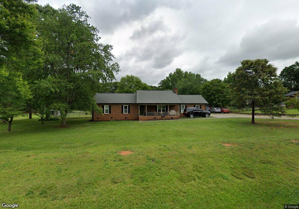
3122 Crow Rd Monroe, NC 28112
Estimated Value: $327,000 - $436,000
3
Beds
2
Baths
1,973
Sq Ft
$196/Sq Ft
Est. Value
About This Home
This home is located at 3122 Crow Rd, Monroe, NC 28112 and is currently estimated at $385,912, approximately $195 per square foot. 3122 Crow Rd is a home located in Union County with nearby schools including Western Union Elementary School, Parkwood Middle School, and Parkwood High School.
Ownership History
Date
Name
Owned For
Owner Type
Purchase Details
Closed on
Jul 31, 2009
Sold by
Rorie Albert Matthew and Rorie Sonya S
Bought by
Broome Matthew A and Broome Kandas L
Current Estimated Value
Home Financials for this Owner
Home Financials are based on the most recent Mortgage that was taken out on this home.
Original Mortgage
$151,000
Outstanding Balance
$95,710
Interest Rate
4.75%
Mortgage Type
Unknown
Estimated Equity
$290,202
Purchase Details
Closed on
Jul 27, 2001
Sold by
Hud
Bought by
Rorie Albert Matthew and Rorie Albert S
Home Financials for this Owner
Home Financials are based on the most recent Mortgage that was taken out on this home.
Original Mortgage
$87,200
Interest Rate
7.08%
Purchase Details
Closed on
Feb 2, 2001
Sold by
Haro Lara Alberto and Haro Lara Erica
Bought by
Hud
Create a Home Valuation Report for This Property
The Home Valuation Report is an in-depth analysis detailing your home's value as well as a comparison with similar homes in the area
Home Values in the Area
Average Home Value in this Area
Purchase History
| Date | Buyer | Sale Price | Title Company |
|---|---|---|---|
| Broome Matthew A | $150,000 | Master Title Agency Llc | |
| Rorie Albert Matthew | -- | -- | |
| Hud | $105,079 | -- |
Source: Public Records
Mortgage History
| Date | Status | Borrower | Loan Amount |
|---|---|---|---|
| Open | Broome Matthew A | $151,000 | |
| Previous Owner | Rorie Albert Matthew | $87,200 |
Source: Public Records
Tax History Compared to Growth
Tax History
| Year | Tax Paid | Tax Assessment Tax Assessment Total Assessment is a certain percentage of the fair market value that is determined by local assessors to be the total taxable value of land and additions on the property. | Land | Improvement |
|---|---|---|---|---|
| 2024 | $1,432 | $222,700 | $39,500 | $183,200 |
| 2023 | $1,413 | $222,700 | $39,500 | $183,200 |
| 2022 | $1,413 | $222,700 | $39,500 | $183,200 |
| 2021 | $1,403 | $222,700 | $39,500 | $183,200 |
| 2020 | $1,111 | $144,040 | $24,040 | $120,000 |
| 2019 | $1,132 | $144,040 | $24,040 | $120,000 |
| 2018 | $1,132 | $144,040 | $24,040 | $120,000 |
| 2017 | $1,206 | $144,000 | $24,000 | $120,000 |
| 2016 | $1,167 | $144,040 | $24,040 | $120,000 |
| 2015 | $1,186 | $144,040 | $24,040 | $120,000 |
| 2014 | $1,058 | $151,950 | $31,400 | $120,550 |
Source: Public Records
Map
Nearby Homes
- 3210 Crow Rd
- 3303 Reid Cir
- 5200 Lancaster Hwy
- 3624 Crow Rd
- 4805 Nesbit Rd
- 5106 Pond Bluff Dr
- 0 Parkwood School Rd
- 4114 Mcmanus Rd Unit 1p
- 6419 Lancaster Hwy Unit 9, 19
- 4120 Mcmanus Rd
- 5101 Garden Gate Dr
- 5313 Old Highway Rd
- 2822 Molly Pop Ln
- 0 Nesbit Rd Unit CAR4290917
- 2109 Long Hope Rd
- TA3000 Plan at Stonebridge Fairways
- Kensington Plan at Stonebridge Fairways
- Lenox Plan at Stonebridge Fairways
- Kemp Plan at Stonebridge Fairways
- Devin Plan at Stonebridge Fairways