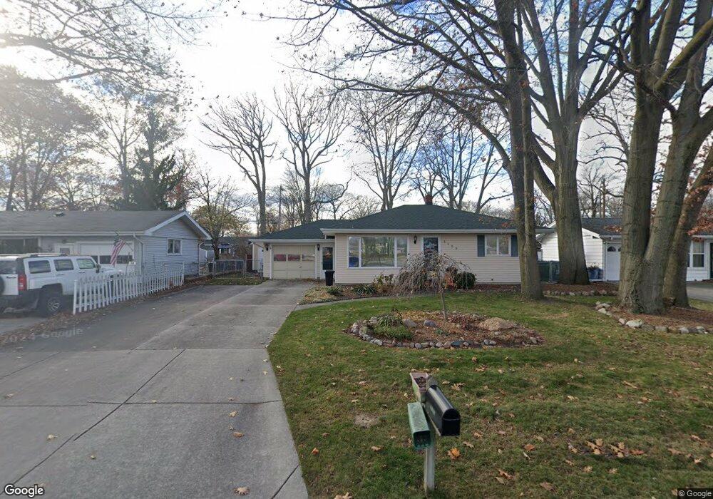
3125 Pine Grove Ave Port Huron, MI 48060
Estimated Value: $151,000 - $205,000
2
Beds
1
Bath
1,192
Sq Ft
$156/Sq Ft
Est. Value
About This Home
This home is located at 3125 Pine Grove Ave, Port Huron, MI 48060 and is currently estimated at $186,382, approximately $156 per square foot. 3125 Pine Grove Ave is a home located in St. Clair County with nearby schools including H.D. Crull Elementary School, Holland Woods Middle School, and Port Huron Northern High School.
Ownership History
Date
Name
Owned For
Owner Type
Purchase Details
Closed on
Jan 10, 2022
Sold by
Backstrom Carol Jean
Bought by
Backstrom Carol Jean and Coger Lacey Marie
Current Estimated Value
Purchase Details
Closed on
Oct 13, 2005
Sold by
Obrien Matthew M and Obrien Deborah R
Bought by
Backstrom Carol
Home Financials for this Owner
Home Financials are based on the most recent Mortgage that was taken out on this home.
Original Mortgage
$79,920
Interest Rate
5.8%
Mortgage Type
New Conventional
Create a Home Valuation Report for This Property
The Home Valuation Report is an in-depth analysis detailing your home's value as well as a comparison with similar homes in the area
Home Values in the Area
Average Home Value in this Area
Purchase History
| Date | Buyer | Sale Price | Title Company |
|---|---|---|---|
| Backstrom Carol Jean | -- | None Listed On Document | |
| Backstrom Carol | $99,900 | Metropolitan Title Co |
Source: Public Records
Mortgage History
| Date | Status | Borrower | Loan Amount |
|---|---|---|---|
| Previous Owner | Backstrom Carol | $79,920 |
Source: Public Records
Tax History Compared to Growth
Tax History
| Year | Tax Paid | Tax Assessment Tax Assessment Total Assessment is a certain percentage of the fair market value that is determined by local assessors to be the total taxable value of land and additions on the property. | Land | Improvement |
|---|---|---|---|---|
| 2025 | $2,412 | $78,600 | $0 | $0 |
| 2024 | $2,062 | $76,700 | $0 | $0 |
| 2023 | $1,948 | $70,100 | $0 | $0 |
| 2022 | $2,057 | $64,000 | $0 | $0 |
| 2021 | $1,953 | $64,600 | $0 | $0 |
| 2020 | $1,975 | $57,000 | $57,000 | $0 |
| 2019 | $1,940 | $42,300 | $0 | $0 |
| 2018 | $1,778 | $42,300 | $0 | $0 |
| 2017 | $1,588 | $42,300 | $0 | $0 |
| 2016 | $1,359 | $42,300 | $0 | $0 |
| 2015 | $1,333 | $40,900 | $40,900 | $0 |
| 2014 | $1,333 | $40,200 | $40,200 | $0 |
| 2013 | -- | $36,600 | $0 | $0 |
Source: Public Records
Map
Nearby Homes
- 3208 Mount Vernon Rd
- 2835 17th Ave
- 1531 Robinson St
- 2812 19th Ave
- 3419 Riverside Dr
- 2913 11th Ave
- 1434 Schumaker St
- 2857 Riverside Dr
- 1424 Hazelwood Ln
- 3214 Poplar St
- 1202 Palmer Ct
- 1218 Garfield St
- 3321 Stone St
- 1020 Sanborn St
- 3515 Strawberry Ln
- 2806 Woodstock Dr
- 1116 Hancock St
- 2549 Riverwood Dr
- 3455 Gratiot Ave
- 3196 Oakwood Dr
- 3131 Pine Grove Ave
- 3121 Pine Grove Ave
- 3117 Pine Grove Ave
- 3126 Mount Vernon Rd
- 3132 Mount Vernon Rd
- 3109 Pine Grove Ave
- 3118 Mount Vernon Rd
- 2105 Concord Place
- 3126 Mt Vernon
- 3208 Mt Vernon Rd
- 3110 Mount Vernon Rd
- 3213 Pine Grove Ave
- 3104 Mount Vernon Rd
- 3037 Pine Grove Ave
- 3100 Mount Vernon Rd
- 517 Concord Place
- 3221 Pine Grove Ave
- 3036 Mount Vernon Rd
- 2204 Concord Place
- 3119 Mount Vernon Rd