
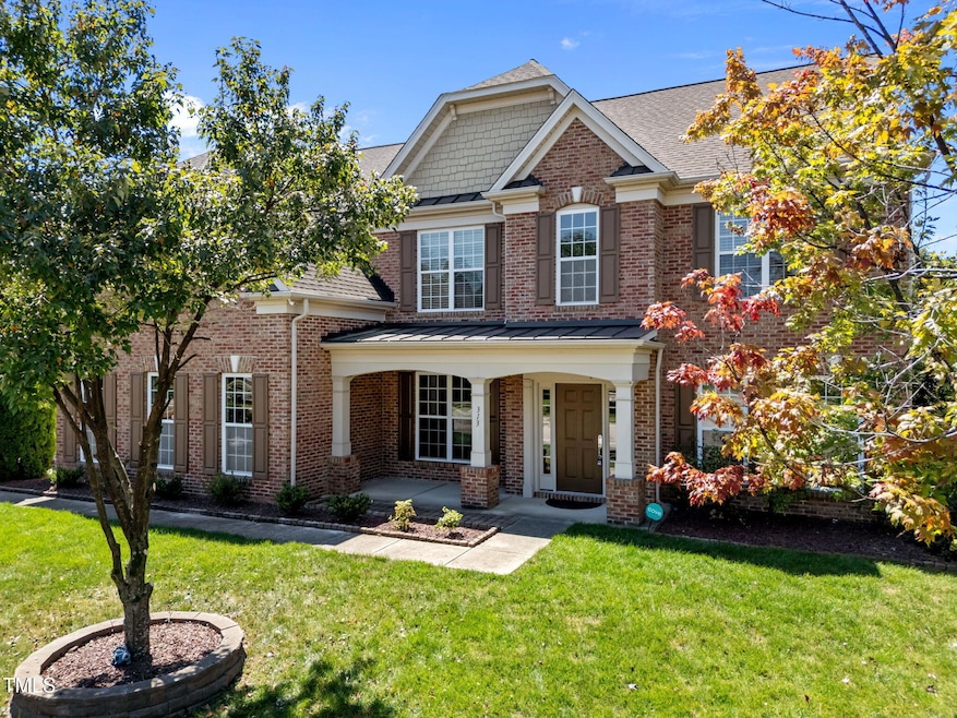
313 Alliance Cir Cary, NC 27519
West Cary NeighborhoodEstimated payment $6,054/month
Total Views
72,123
5
Beds
4
Baths
3,400
Sq Ft
$293
Price per Sq Ft
Highlights
- Outdoor Pool
- Clubhouse
- Wood Flooring
- Turner Creek Elementary School Rated A-
- Transitional Architecture
- Main Floor Bedroom
About This Home
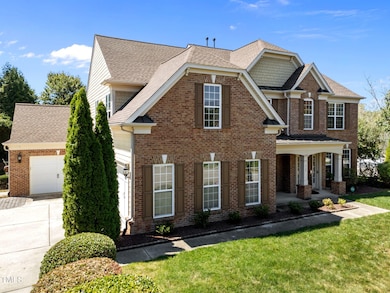
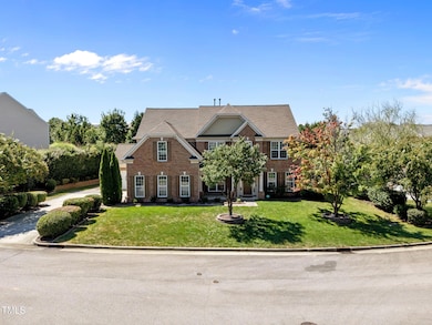
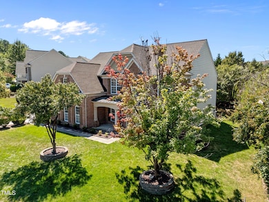
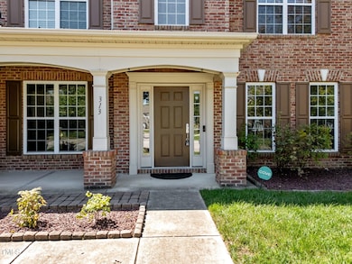
Discover the perfect blend of elegance, comfort, and community in this stunning 3,400 sq. ft. North-East facing home on 0.35 acres in sought-after Harmony Reserve, Cary. With 5 bedrooms, 4 full bathrooms, a dedicated office, and a spacious bonus room, this residence is designed for modern living and unforgettable entertaining.
Step inside to soaring spaces filled with natural light, freshly painted interiors, and a seamless open layout. At the heart of the home, the dream kitchen features a large granite island, cherry cabinets, tile floors, stainless steel appliances, and a gas range—perfect for both everyday meals and hosting. The expansive living and dining areas flow effortlessly for gatherings of any size, while a first-floor guest suite with full bath offers convenience and privacy.
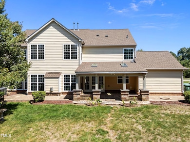
Outdoor living shines with a huge extended, covered patio with skylights—a year-round retreat for relaxing or entertaining. The private, landscaped backyard boasts two raised garden beds, ideal for vegetables, flowers, or simply enjoying nature. Peace of mind comes with a new roof and a wired 4-camera security system, making this home truly move-in ready.
Beyond the property, Harmony Reserve offers resort-style amenities: a clubhouse, massive swimming pool with water slides and lifeguards, tennis courts, playgrounds, and even a summer swim team. Families will love the walkable access to Turner Creek Elementary and proximity to Beaver Creek Shopping, Apex and Parkside, ParkWest & Fenton shopping in Cary, restaurants, parks, and top-rated Wake County schools. Enjoy quick access to Hwy 55, 540, RTP, RDU Airport, and Downtown Cary.
This is more than a home—it's a lifestyle. Whether hosting friends under the patio skylights, gardening in your private oasis, or joining community events at the clubhouse, every day feels like a getaway.
Welcome to Harmony Reserve. Welcome Home!
Home Details
Home Type
- Single Family
Est. Annual Taxes
- $8,333
Year Built
- Built in 2009
Lot Details
- 0.35 Acre Lot
- Northeast Facing Home
- Fenced Yard
- Fenced Front Yard
- Vinyl Fence
HOA Fees
- $105 Monthly HOA Fees
Parking
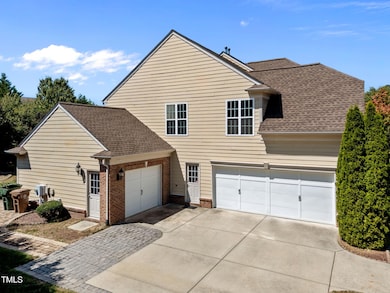
- 3 Car Attached Garage
- 2 Open Parking Spaces
Home Design
- Transitional Architecture
- Entry on the 1st floor
- Brick Exterior Construction
- Block Foundation
- Slab Foundation
- Shingle Roof
- Fiberglass Roof
Interior Spaces
- 3,400 Sq Ft Home
- 2-Story Property
- High Ceiling
- 1 Fireplace
- Entrance Foyer
- Family Room
- Living Room
- Breakfast Room
- Dining Room
- Home Office
- Bonus Room
- Utility Room
Kitchen
- Double Oven
- Gas Cooktop
- Down Draft Cooktop
- Dishwasher
Flooring
- Wood
- Carpet
- Ceramic Tile
Bedrooms and Bathrooms
- 5 Bedrooms
- Main Floor Bedroom
- Primary bedroom located on second floor
- 4 Full Bathrooms
Laundry
- Laundry on main level
- Electric Dryer Hookup
Accessible Home Design
- Accessible Common Area
Outdoor Features
- Outdoor Pool
- Patio
Schools
- Turner Creek Road Year Round Elementary School
- Salem Middle School
- Green Level High School
Utilities
- Forced Air Zoned Heating and Cooling System
- Heating System Uses Natural Gas
- Gas Water Heater
Listing and Financial Details
- Assessor Parcel Number 0733683333
Community Details
Overview
- Association fees include storm water maintenance
- Harmony Hoa/Hrw Association, Phone Number (919) 787-9000
- Harmony Subdivision
Amenities
- Clubhouse
Recreation
- Community Playground
- Community Pool
Map
Create a Home Valuation Report for This Property
The Home Valuation Report is an in-depth analysis detailing your home's value as well as a comparison with similar homes in the area
Home Values in the Area
Average Home Value in this Area
Tax History
| Year | Tax Paid | Tax Assessment Tax Assessment Total Assessment is a certain percentage of the fair market value that is determined by local assessors to be the total taxable value of land and additions on the property. | Land | Improvement |
|---|---|---|---|---|
| 2025 | $8,333 | $969,942 | $250,000 | $719,942 |
| 2024 | $8,153 | $969,942 | $250,000 | $719,942 |
| 2023 | $5,753 | $572,150 | $112,000 | $460,150 |
| 2022 | $5,538 | $572,150 | $112,000 | $460,150 |
| 2021 | $5,427 | $572,150 | $112,000 | $460,150 |
| 2020 | $5,455 | $572,150 | $112,000 | $460,150 |
| 2019 | $5,403 | $502,768 | $125,000 | $377,768 |
| 2018 | $5,070 | $502,768 | $125,000 | $377,768 |
| 2017 | $4,754 | $490,620 | $125,000 | $365,620 |
| 2016 | $4,683 | $490,620 | $125,000 | $365,620 |
| 2015 | $4,546 | $459,742 | $100,000 | $359,742 |
| 2014 | $4,286 | $459,742 | $100,000 | $359,742 |
Source: Public Records
Property History
| Date | Event | Price | List to Sale | Price per Sq Ft |
|---|---|---|---|---|
| 09/05/2025 09/05/25 | For Sale | $997,000 | -- | $293 / Sq Ft |
Source: Doorify MLS
Purchase History
| Date | Type | Sale Price | Title Company |
|---|---|---|---|
| Warranty Deed | $426,000 | None Available |
Source: Public Records
Mortgage History
| Date | Status | Loan Amount | Loan Type |
|---|---|---|---|
| Closed | $340,600 | New Conventional |
Source: Public Records
About the Listing Agent
Specializing in Existing Homes, New Construction including CUSTOM homes, Land and Investment properties
Experienced and effective Buyer representative
Management, Financial, Pricing, Purchasing, and Selling experience.
Licensed and experienced Real Estate Broker
Member, Raleigh Regional Board of Realtors.
Member, National Association of Realtors.
Member of the Triangle Multiple Listing Service - I can show and sell you ANY of the properties listed in the MLS.
Joe's Other Listings
Source: Doorify MLS
MLS Number: 10120108
APN: 0733.02-68-3333-000
Disclaimer: Certain information contained herein is derived from information provided by parties other than Homes.com. All information provided is deemed reliable, but is not guaranteed to be accurate and should be independently verified.
![]() Some IDX listings have been excluded from this IDX display. Brokers make an effort to deliver accurate information, but buyers should independently verify any information on which they will rely in a transaction. The listing broker shall not be responsible for any typographical errors, misinformation, or misprints, and they shall be held totally harmless from any damages arising from reliance upon this data. This data is provided exclusively for consumers’ personal, non-commercial use. Listings marked with an icon are provided courtesy of the Doorify MLS, Inc. of North Carolina, Internet Data Exchange Database. Closed (sold) listings may have been listed and/or sold by a real estate firm other than the firm(s) featured on this website. Closed data is not available until the sale of the property is recorded in the MLS. Home sale data is not an appraisal, CMA, competitive or comparative market analysis, or home valuation of any property. Copyright 2025 Doorify MLS, Inc. of North Carolina. All rights reserved.
Some IDX listings have been excluded from this IDX display. Brokers make an effort to deliver accurate information, but buyers should independently verify any information on which they will rely in a transaction. The listing broker shall not be responsible for any typographical errors, misinformation, or misprints, and they shall be held totally harmless from any damages arising from reliance upon this data. This data is provided exclusively for consumers’ personal, non-commercial use. Listings marked with an icon are provided courtesy of the Doorify MLS, Inc. of North Carolina, Internet Data Exchange Database. Closed (sold) listings may have been listed and/or sold by a real estate firm other than the firm(s) featured on this website. Closed data is not available until the sale of the property is recorded in the MLS. Home sale data is not an appraisal, CMA, competitive or comparative market analysis, or home valuation of any property. Copyright 2025 Doorify MLS, Inc. of North Carolina. All rights reserved.
Nearby Homes
- 112 Rapport Dr
- 702 Unison Ct
- 424 Euphoria Cir
- 203 Caraway Ln
- 302 Caraway Ln
- 112 Amiable Loop
- 205 Caniff Ln
- 411 Amiable Loop
- 309 Amiable Loop
- 322 Parkmeadow Dr
- 6716 Valley Woods Ln
- 302 Parkbranch Ln
- 200 Carpenter Brook Dr
- 209 Parkmeadow Dr
- 206 Highfield Ave
- 108 Ferncroft Ct
- 102 W Hill Dr
- 205 Wedgemere St
- 440 Creekhurst Place
- 6824 Wood Forest Dr
- 101 Stanza Ct
- 316 Rapport Dr
- 1209 Corkery Ridge Ct
- 321 Brk Pne Trail
- 201 Union Mills Way
- 469 Clark Creek Ln
- 473 Autumn Rain St
- 214 Castle Hayne Dr
- 1905 Castleburg Dr
- 267 Crestmont Ridge Dr
- 2413 Fillmore Hall Ln
- 408 Parlier Dr
- 1000 Cameron Woods Dr
- 100 Terrastone Place
- 138 Sunstone Dr
- 904 Cozy Oak Ave
- 2312 Colony Woods Dr
- 407 Daylin Dr
- 210 Silk Hope Dr
- 234 Daymire Glen Ln