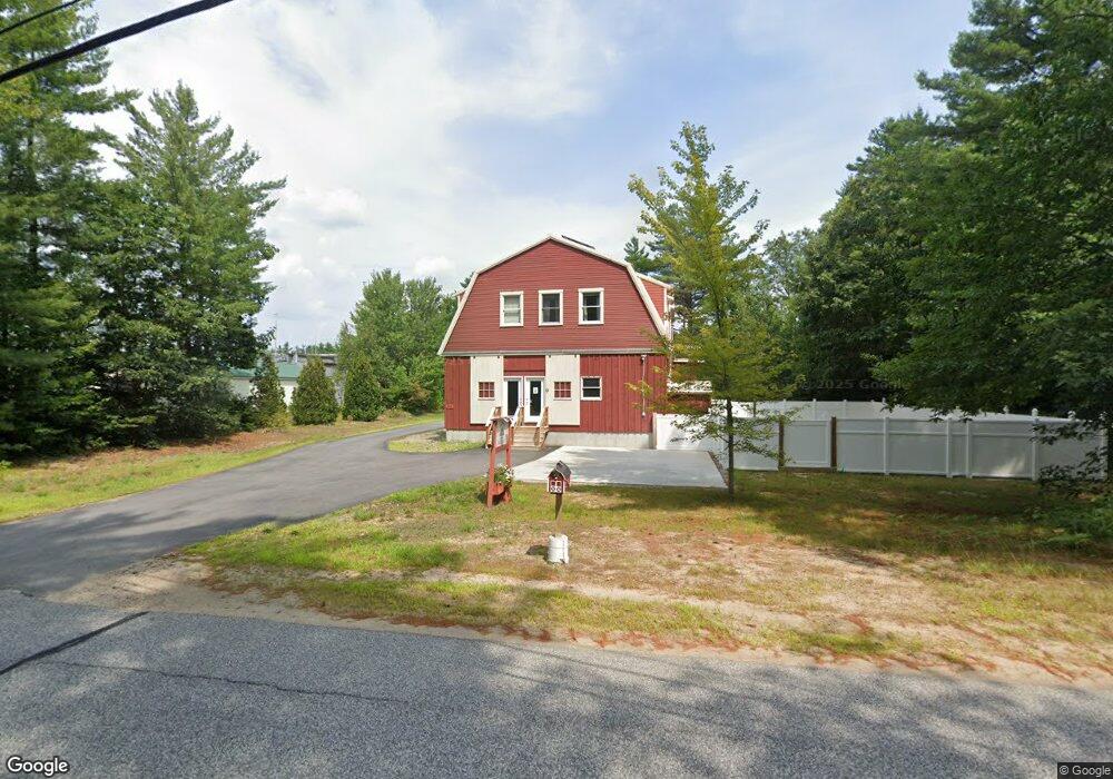
313 Maple Rd Chocorua, NH 03817
Estimated Value: $534,731 - $617,000
3
Beds
3
Baths
4,034
Sq Ft
$145/Sq Ft
Est. Value
About This Home
This home is located at 313 Maple Rd, Chocorua, NH 03817 and is currently estimated at $582,933, approximately $144 per square foot. 313 Maple Rd is a home with nearby schools including Kenneth A. Brett School.
Ownership History
Date
Name
Owned For
Owner Type
Purchase Details
Closed on
Aug 15, 2023
Sold by
Stlouis Lyse M
Bought by
Briggs Elizabeth A and Castaldo Anthony J
Current Estimated Value
Home Financials for this Owner
Home Financials are based on the most recent Mortgage that was taken out on this home.
Original Mortgage
$378,400
Outstanding Balance
$368,281
Interest Rate
6.81%
Mortgage Type
Purchase Money Mortgage
Estimated Equity
$214,652
Purchase Details
Closed on
Aug 21, 2017
Sold by
Marshall Richard O
Bought by
Marshall Richard O and St Louis Lyse M
Home Financials for this Owner
Home Financials are based on the most recent Mortgage that was taken out on this home.
Original Mortgage
$50,000
Interest Rate
3.96%
Mortgage Type
Credit Line Revolving
Purchase Details
Closed on
Nov 4, 2004
Sold by
Rivas Carolyn
Bought by
Marshall Richard O
Create a Home Valuation Report for This Property
The Home Valuation Report is an in-depth analysis detailing your home's value as well as a comparison with similar homes in the area
Home Values in the Area
Average Home Value in this Area
Purchase History
| Date | Buyer | Sale Price | Title Company |
|---|---|---|---|
| Briggs Elizabeth A | $473,000 | None Available | |
| Marshall Richard O | -- | -- | |
| Marshall Richard O | $32,000 | -- |
Source: Public Records
Mortgage History
| Date | Status | Borrower | Loan Amount |
|---|---|---|---|
| Open | Briggs Elizabeth A | $378,400 | |
| Previous Owner | Marshall Richard O | $50,000 |
Source: Public Records
Tax History
| Year | Tax Paid | Tax Assessment Tax Assessment Total Assessment is a certain percentage of the fair market value that is determined by local assessors to be the total taxable value of land and additions on the property. | Land | Improvement |
|---|---|---|---|---|
| 2025 | $7,455 | $504,400 | $77,500 | $426,900 |
| 2024 | $6,810 | $471,900 | $77,500 | $394,400 |
| 2023 | $7,011 | $277,900 | $44,400 | $233,500 |
| 2022 | $6,606 | $277,900 | $44,400 | $233,500 |
| 2021 | $6,153 | $277,900 | $44,400 | $233,500 |
| 2020 | $6,247 | $277,900 | $44,400 | $233,500 |
| 2019 | $5,986 | $277,900 | $44,400 | $233,500 |
| 2018 | $5,613 | $243,400 | $16,500 | $226,900 |
| 2017 | $5,035 | $221,800 | $16,500 | $205,300 |
| 2016 | $5,088 | $221,800 | $16,500 | $205,300 |
| 2015 | $5,068 | $221,800 | $16,500 | $205,300 |
| 2013 | $4,700 | $235,000 | $27,400 | $207,600 |
Source: Public Records
Map
Nearby Homes
- Lot 18.1 White Mountain Hwy
- 78 Berry Ln
- 24 Flynn Ln
- 14 Lollipop Ln
- Lot 113/114 Rocky Ln
- 80 White Lake Rd
- 71 Mason Dr
- 1 Whittier Rd
- 31 Mcgrew Dr
- 48 South Way
- 206 E Chocorua River Dr
- 439 Silver Pine Ln
- 1785 White Mountain Hwy
- 26 Logan Way
- 36 Logan Way
- 188 White Mountain Hwy
- 748 Plains Rd
- 208 Benjamin Wentworth Dr
- 68 & 00 Gilman Valley & Route 25 W
- 00 Route 25 W Unit tbd
Your Personal Tour Guide
Ask me questions while you tour the home.