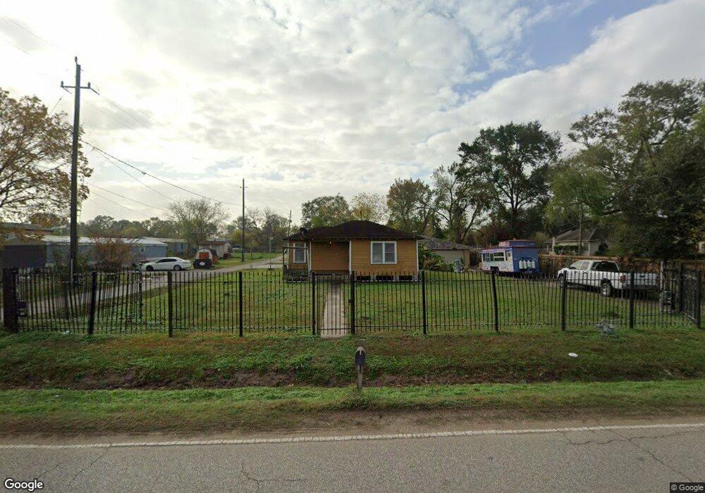
3133 Frick Rd Houston, TX 77038
North Houston NeighborhoodEstimated Value: $214,000 - $281,541
2
Beds
1
Bath
702
Sq Ft
$360/Sq Ft
Est. Value
About This Home
This home is located at 3133 Frick Rd, Houston, TX 77038 and is currently estimated at $252,885, approximately $360 per square foot. 3133 Frick Rd is a home located in Harris County with nearby schools including Kujawa EC/Pre-K/K School, Carter Academy, and Shotwell Middle School.
Ownership History
Date
Name
Owned For
Owner Type
Purchase Details
Closed on
Jul 9, 2013
Sold by
Lovy Robert L
Bought by
Berrones Jose Javier
Current Estimated Value
Home Financials for this Owner
Home Financials are based on the most recent Mortgage that was taken out on this home.
Original Mortgage
$210,000
Outstanding Balance
$152,830
Interest Rate
3.94%
Mortgage Type
Purchase Money Mortgage
Estimated Equity
$100,055
Purchase Details
Closed on
Oct 13, 1999
Sold by
Scroggins Marvin David and Scroggins Lois Bernice
Bought by
Lovy Robert L
Create a Home Valuation Report for This Property
The Home Valuation Report is an in-depth analysis detailing your home's value as well as a comparison with similar homes in the area
Home Values in the Area
Average Home Value in this Area
Purchase History
| Date | Buyer | Sale Price | Title Company |
|---|---|---|---|
| Berrones Jose Javier | -- | First American Title | |
| Lovy Robert L | -- | -- |
Source: Public Records
Mortgage History
| Date | Status | Borrower | Loan Amount |
|---|---|---|---|
| Open | Berrones Jose Javier | $210,000 |
Source: Public Records
Tax History Compared to Growth
Tax History
| Year | Tax Paid | Tax Assessment Tax Assessment Total Assessment is a certain percentage of the fair market value that is determined by local assessors to be the total taxable value of land and additions on the property. | Land | Improvement |
|---|---|---|---|---|
| 2025 | $4,039 | $218,919 | $169,382 | $49,537 |
| 2024 | $4,039 | $231,302 | $184,476 | $46,826 |
| 2023 | $4,039 | $173,985 | $120,748 | $53,237 |
| 2022 | $3,634 | $176,758 | $120,748 | $56,010 |
| 2021 | $3,272 | $151,806 | $92,238 | $59,568 |
| 2020 | $3,255 | $143,300 | $92,238 | $51,062 |
| 2019 | $3,381 | $142,106 | $95,592 | $46,514 |
| 2018 | $2,040 | $142,106 | $95,592 | $46,514 |
| 2017 | $3,221 | $142,106 | $95,592 | $46,514 |
| 2016 | $2,330 | $102,809 | $55,822 | $46,987 |
| 2015 | $1,788 | $81,811 | $48,541 | $33,270 |
| 2014 | $1,788 | $80,179 | $48,541 | $31,638 |
Source: Public Records
Map
Nearby Homes
- 3127 Frick Rd
- 13308 Ann Louise Rd
- 2838 Packard Elm St
- 2835 Oakland Brook St
- 2831 Oakland Brook St
- 3265 Frick Rd
- 2811 Oakland Brook St
- 12623 Ann Louise Rd
- 2719 Magnolia Hill Trail
- 2614 Lemonwood Ln
- 5914 Stirring Winds Ln
- 00 Essie Rd
- 2530 Woodtown Dr
- 13518 Kaltenbrun Rd
- 3240 Brownie Campbell Rd
- 10730 Antoine Dr
- 13610 Kaltenbrun Rd
- 10214 Trade Winds Dr
- 6411 Halstead Meadows Cir
- 6606 Dusty Dawn Dr
- 3145 Frick Rd
- 3125 Frick Rd
- 3117 Frick Rd
- 3175 Frick Rd
- 3150 Frick Rd
- 3101 Frick Rd
- 3118 Frick Rd
- 3102 Frick Rd
- 3174 Frick Rd
- 13101 Sundale Rd
- 12518 Ann Louise Rd
- 3110 Frick Rd
- 3033 Frick Rd
- 3166 Frick Rd
- 13054 Sundale Rd
- 3179 Frick Rd
- 13051 Ann Louise Rd
- 12838 Ann Louise Rd
- 3034 Frick Rd
- 3202 Frick Rd