
Seller's Agent in 2016
Norris Bishop
Norris Bishop Realty, LLC
(229) 589-1044
447 Total Sales
Estimated Value: $65,000 - $86,593
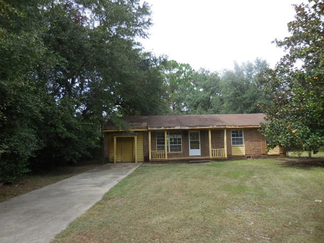
Modest 3 bedroom 1.5 bathroom home located in the Albany area. This house offers hardwood flooring in some of the rooms, and tile in the bathrooms and the kitchen. Large fenced backyard. This home also offers a laundry room, a living room, kitchen/dining combo and a den. Call for more information or to schedule your viewing!
Last Agent to Sell the Property
Norris Bishop Realty, LLC Brokerage Phone: 2298901186 License #263490 Listed on: 12/28/2015
Last Buyer's Agent
Non Member
Non Member Office
| Date | Buyer | Sale Price | Title Company |
|---|---|---|---|
| Grady Eunice | $14,398 | -- | |
| Sec Of Housing & Urban | $80,631 | -- | |
| Bank Of America | -- | -- | |
| Evans Erica Y | $52,500 | -- | |
| Washington Pink Jr | -- | -- |
| Date | Event | Price | List to Sale | Price per Sq Ft |
|---|---|---|---|---|
| 01/28/2016 01/28/16 | Sold | $14,398 | -- | $12 / Sq Ft |
| 12/28/2015 12/28/15 | Pending | -- | -- | -- |
| Year | Tax Paid | Tax Assessment Tax Assessment Total Assessment is a certain percentage of the fair market value that is determined by local assessors to be the total taxable value of land and additions on the property. | Land | Improvement |
|---|---|---|---|---|
| 2024 | $1,000 | $20,960 | $2,200 | $18,760 |
| 2023 | $977 | $20,960 | $2,200 | $18,760 |
| 2022 | $980 | $20,960 | $2,200 | $18,760 |
| 2021 | $909 | $20,960 | $2,200 | $18,760 |
| 2020 | $911 | $20,960 | $2,200 | $18,760 |
| 2019 | $914 | $20,960 | $2,200 | $18,760 |
| 2018 | $918 | $20,960 | $2,200 | $18,760 |
| 2017 | $235 | $20,960 | $2,200 | $18,760 |
| 2016 | $856 | $20,960 | $2,200 | $18,760 |
| 2015 | $858 | $20,960 | $2,200 | $18,760 |
| 2014 | $847 | $20,960 | $2,200 | $18,760 |
Seller's Agent in 2016
Norris Bishop
Norris Bishop Realty, LLC
(229) 589-1044
447 Total Sales
N
Buyer's Agent in 2016
Non Member
Non Member Office
Source: Albany Board of REALTORS®
MLS Number: 134716
APN: 0000X-00003-032