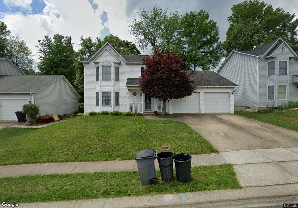
314 Goforth Dr Havre de Grace, MD 21078
Estimated Value: $390,716 - $442,000
3
Beds
3
Baths
1,700
Sq Ft
$244/Sq Ft
Est. Value
About This Home
This home is located at 314 Goforth Dr, Havre de Grace, MD 21078 and is currently estimated at $414,429, approximately $243 per square foot. 314 Goforth Dr is a home located in Harford County with nearby schools including Meadowvale Elementary School, Havre de Grace Middle School, and Havre de Grace High School.
Ownership History
Date
Name
Owned For
Owner Type
Purchase Details
Closed on
Jan 14, 2011
Sold by
Rajaski John James and Rajaski Sandra S
Bought by
Mirabile Joseph W and Mirabile Gretchen
Current Estimated Value
Home Financials for this Owner
Home Financials are based on the most recent Mortgage that was taken out on this home.
Original Mortgage
$253,409
Outstanding Balance
$170,437
Interest Rate
4.5%
Mortgage Type
FHA
Estimated Equity
$243,992
Purchase Details
Closed on
May 23, 1990
Sold by
Durinzi David D
Bought by
Rajaski John James
Home Financials for this Owner
Home Financials are based on the most recent Mortgage that was taken out on this home.
Original Mortgage
$138,200
Interest Rate
10.37%
Create a Home Valuation Report for This Property
The Home Valuation Report is an in-depth analysis detailing your home's value as well as a comparison with similar homes in the area
Home Values in the Area
Average Home Value in this Area
Purchase History
| Date | Buyer | Sale Price | Title Company |
|---|---|---|---|
| Mirabile Joseph W | $260,000 | Worldwide Title Group Llc | |
| Rajaski John James | $136,500 | -- |
Source: Public Records
Mortgage History
| Date | Status | Borrower | Loan Amount |
|---|---|---|---|
| Open | Mirabile Joseph W | $253,409 | |
| Previous Owner | Rajaski John James | $138,200 |
Source: Public Records
Tax History Compared to Growth
Tax History
| Year | Tax Paid | Tax Assessment Tax Assessment Total Assessment is a certain percentage of the fair market value that is determined by local assessors to be the total taxable value of land and additions on the property. | Land | Improvement |
|---|---|---|---|---|
| 2025 | $2,462 | $273,700 | $0 | $0 |
| 2024 | $2,462 | $258,300 | $83,000 | $175,300 |
| 2023 | $2,394 | $251,167 | $0 | $0 |
| 2022 | $2,326 | $244,033 | $0 | $0 |
| 2021 | $1,191 | $236,900 | $83,000 | $153,900 |
| 2020 | $1,191 | $231,400 | $0 | $0 |
| 2019 | $2,272 | $225,900 | $0 | $0 |
| 2018 | $2,197 | $220,400 | $93,000 | $127,400 |
| 2017 | $2,197 | $220,400 | $0 | $0 |
| 2016 | -- | $220,400 | $0 | $0 |
| 2015 | $2,392 | $221,100 | $0 | $0 |
| 2014 | $2,392 | $221,100 | $0 | $0 |
Source: Public Records
Map
Nearby Homes
- 101 Susquehanna Ct
- 102 Tidewater Dr
- Somerset II - Bulle Rock Plan at Bulle Rock - Single Family
- Chartwell Plan at Bulle Rock - Single Family
- Franklin Plan at Bulle Rock - Single Family
- Hampton II Plan at Bulle Rock - Single Family
- Patton Plan at Bulle Rock - Single Family
- Augusta Plan at Bulle Rock - Single Family
- Alexander II Plan at Bulle Rock - Single Family
- Andrews Plan at Bulle Rock - Single Family
- Somerset Plan at Bulle Rock - Single Family
- 539 Whimsical Dr
- 321 Friar Rock Cir
- 302 Friar Rock Cir
- 300 Friar Rock Cir
- TBB-AUGUSTA Whimsical Dr
- 330 Friar Rock Cir
- TBB-TOLCHESTER II Whimsical Dr
- 400 Brant Ct
- TBB-PATTON Whimsical Dr