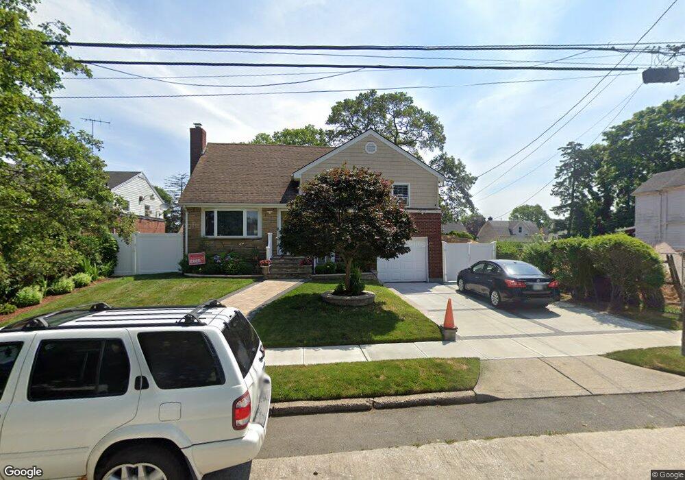
314 N Columbus Ave Freeport, NY 11520
Estimated Value: $558,588 - $576,000
--
Bed
2
Baths
1,244
Sq Ft
$456/Sq Ft
Est. Value
About This Home
This home is located at 314 N Columbus Ave, Freeport, NY 11520 and is currently estimated at $567,294, approximately $456 per square foot. 314 N Columbus Ave is a home located in Nassau County with nearby schools including Columbus Avenue School, Caroline G. Atkinson Intermediate School, and John W Dodd Middle School.
Ownership History
Date
Name
Owned For
Owner Type
Purchase Details
Closed on
Mar 23, 2005
Sold by
Ethridge Larry
Bought by
Puello Pedro
Current Estimated Value
Purchase Details
Closed on
Oct 8, 1999
Sold by
Better Homes Depot Inc
Bought by
Ethridge Larry and Bigelow Gwendolyn
Home Financials for this Owner
Home Financials are based on the most recent Mortgage that was taken out on this home.
Original Mortgage
$203,324
Interest Rate
7.83%
Mortgage Type
FHA
Purchase Details
Closed on
May 4, 1999
Create a Home Valuation Report for This Property
The Home Valuation Report is an in-depth analysis detailing your home's value as well as a comparison with similar homes in the area
Home Values in the Area
Average Home Value in this Area
Purchase History
| Date | Buyer | Sale Price | Title Company |
|---|---|---|---|
| Puello Pedro | $344,000 | -- | |
| Ethridge Larry | $205,000 | Commonwealth Land Title Ins | |
| -- | $95,300 | -- |
Source: Public Records
Mortgage History
| Date | Status | Borrower | Loan Amount |
|---|---|---|---|
| Previous Owner | Ethridge Larry | $203,324 |
Source: Public Records
Tax History Compared to Growth
Tax History
| Year | Tax Paid | Tax Assessment Tax Assessment Total Assessment is a certain percentage of the fair market value that is determined by local assessors to be the total taxable value of land and additions on the property. | Land | Improvement |
|---|---|---|---|---|
| 2025 | $7,125 | $372 | $128 | $244 |
| 2024 | $882 | $389 | $135 | $254 |
| 2023 | $6,881 | $367 | $127 | $240 |
| 2022 | $6,881 | $386 | $135 | $251 |
| 2021 | $11,213 | $365 | $126 | $239 |
| 2020 | $7,990 | $644 | $337 | $307 |
| 2019 | $8,139 | $690 | $336 | $354 |
| 2018 | $8,555 | $742 | $0 | $0 |
| 2017 | $7,530 | $742 | $361 | $381 |
| 2016 | $8,643 | $742 | $361 | $381 |
| 2015 | $1,072 | $742 | $361 | $381 |
| 2014 | $1,072 | $742 | $361 | $381 |
| 2013 | $1,013 | $742 | $361 | $381 |
Source: Public Records
Map
Nearby Homes
- 272 N Columbus Ave
- 259 N Columbus Ave
- 238 Babylon Turnpike
- 173 E Seaman Ave
- 92 Leonard Ave
- 451 Babylon Turnpike
- 400 N Columbus Ave
- 112 E Seaman Ave
- 110 Woodside Ave
- 101 Harris Ave
- 93 Woodside Ave
- 28 Cumberland Ave
- 221 E Dean St
- 251 Grand Ave
- 67 E Dean St
- 19 Bennett Ave
- 182 Grand Ave
- 110 Saint Francis St
- 161 Grand Ave
- 94 Underhill Ave
- 184 Independence Ave
- 188 Independence Ave
- 280 N Columbus Ave
- 172 Independence Ave
- 303 Rutland Rd
- 315 Rutland Rd
- 202 Independence Ave
- 303 N Columbus Ave
- 324 N Columbus Ave
- 299 Rutland Rd
- 168 Independence Ave
- 281 N Col Ave
- 281 N Columbus Ave
- 297 Rutland Rd
- 277 N Columbus Ave
- 162 Independence Ave
- 169 Independence Ave
- 187 Independence Ave
- 330 N Columbus Ave
- 274 N Columbus Ave