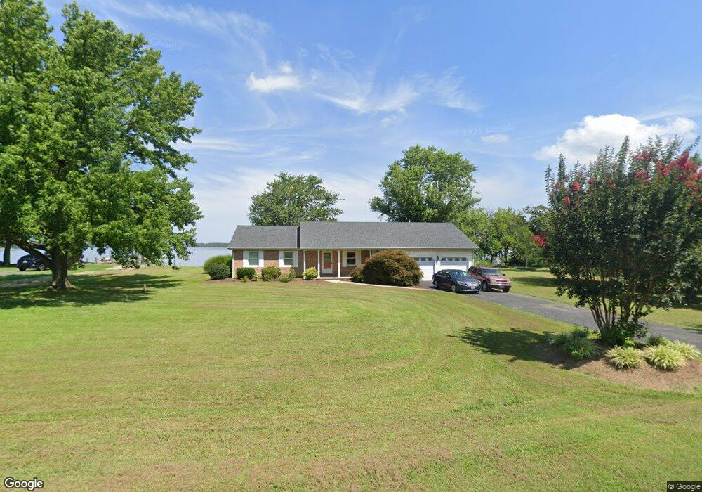
314 Old Point Rd Chester, MD 21619
Estimated Value: $658,000 - $1,017,000
Studio
2
Baths
2,012
Sq Ft
$424/Sq Ft
Est. Value
About This Home
This home is located at 314 Old Point Rd, Chester, MD 21619 and is currently estimated at $852,737, approximately $423 per square foot. 314 Old Point Rd is a home located in Queen Anne's County with nearby schools including Kent Island Elementary School, Bayside Elementary School, and Matapeake Middle School.
Ownership History
Date
Name
Owned For
Owner Type
Purchase Details
Closed on
May 10, 1999
Sold by
Hamilton Michael W and Hamilton Betsy A
Bought by
Peake William T and Peake Diane E
Current Estimated Value
Purchase Details
Closed on
Apr 21, 1983
Sold by
Coursey Wm W and Coursey John L And
Bought by
Hamilton Michael W and Hamilton Betsy A
Home Financials for this Owner
Home Financials are based on the most recent Mortgage that was taken out on this home.
Original Mortgage
$40,000
Interest Rate
12.79%
Create a Home Valuation Report for This Property
The Home Valuation Report is an in-depth analysis detailing your home's value as well as a comparison with similar homes in the area
Purchase History
| Date | Buyer | Sale Price | Title Company |
|---|---|---|---|
| Peake William T | $298,000 | -- | |
| Hamilton Michael W | $51,000 | -- |
Source: Public Records
Mortgage History
| Date | Status | Borrower | Loan Amount |
|---|---|---|---|
| Previous Owner | Hamilton Michael W | $40,000 | |
| Closed | Peake William T | -- |
Source: Public Records
Tax History
| Year | Tax Paid | Tax Assessment Tax Assessment Total Assessment is a certain percentage of the fair market value that is determined by local assessors to be the total taxable value of land and additions on the property. | Land | Improvement |
|---|---|---|---|---|
| 2025 | $6,236 | $695,833 | $0 | $0 |
| 2024 | $5,919 | $642,767 | $0 | $0 |
| 2023 | $5,615 | $589,700 | $402,000 | $187,700 |
| 2022 | $5,615 | $589,700 | $402,000 | $187,700 |
| 2021 | $5,823 | $589,700 | $402,000 | $187,700 |
| 2020 | $5,823 | $600,900 | $455,900 | $145,000 |
| 2019 | $5,683 | $586,300 | $0 | $0 |
| 2018 | $5,543 | $571,700 | $0 | $0 |
| 2017 | $5,403 | $557,100 | $0 | $0 |
| 2016 | -- | $557,100 | $0 | $0 |
| 2015 | $2,523 | $557,100 | $0 | $0 |
| 2014 | $2,523 | $564,100 | $0 | $0 |
Source: Public Records
Map
Nearby Homes
- 1405 Little Creek Rd
- 0 Parks Rd
- 1150 Little Creek Rd
- 1868 Roberta Dr
- 1340 Queen Anne Dr
- 203 Wineland Way
- 1337 Queen Anne Dr
- 1401 Calvert Rd
- 200 Newtown Rd
- 1709 Batts Neck Rd
- 2613 Cecil Dr
- 0 Newtown Rd
- 1757 Harbor Dr
- 103 Chesapeake Estates Dr
- Lot 6 Norman Ct
- 644 Moorings Cir
- 614 Moorings Cir
- Lot 7 Maple Rd
- 1704 Bayside Dr
- 0 Bay Dr Unit MDQA2016060
- 316 Old Point Rd
- 315 Old Point Rd
- 104 Old Point Rd
- 309 Old Point Rd
- 308 Old Point Rd
- 503 Old Point Rd
- 307 Old Point Rd
- 307 Old Point Rd
- 601 Old Point Rd
- 500 Old Point Rd
- 401 Old Point Rd
- 605 Old Point Dr
- 603 Old Point Rd
- 605 Old Point Rd
- 100 Cox Ct
- 104 Olde Point Village
- 600 Old Point Rd
- 607 Old Point Rd
- 102 Cox Ct
- 602 Old Point Rd
Your Personal Tour Guide
Ask me questions while you tour the home.