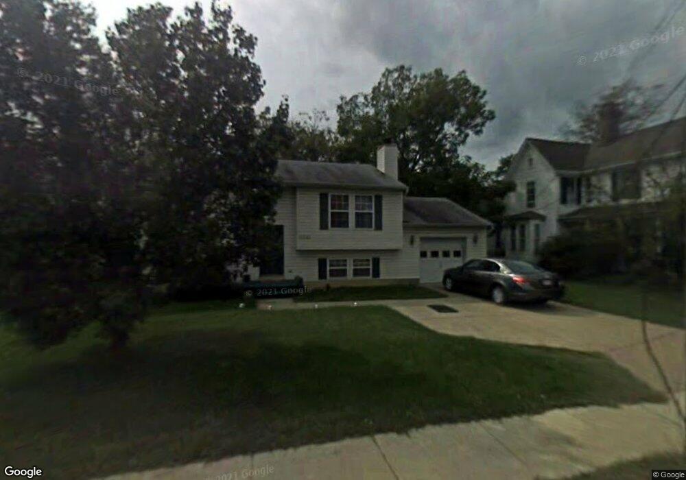
314 Talbott Ave Laurel, MD 20707
Estimated Value: $424,000 - $463,768
Studio
3
Baths
1,114
Sq Ft
$403/Sq Ft
Est. Value
About This Home
This home is located at 314 Talbott Ave, Laurel, MD 20707 and is currently estimated at $448,442, approximately $402 per square foot. 314 Talbott Ave is a home located in Prince George's County with nearby schools including Laurel Elementary School, Dwight D. Eisenhower Middle School, and Laurel High School.
Ownership History
Date
Name
Owned For
Owner Type
Purchase Details
Closed on
Apr 9, 2002
Sold by
Nicholson Linda D
Bought by
Ballard Thomas Q and Ballard Linda D
Current Estimated Value
Purchase Details
Closed on
Apr 5, 1994
Sold by
Pro Development Group Inc
Bought by
Nicholson Linda D
Home Financials for this Owner
Home Financials are based on the most recent Mortgage that was taken out on this home.
Original Mortgage
$150,792
Interest Rate
7.07%
Create a Home Valuation Report for This Property
The Home Valuation Report is an in-depth analysis detailing your home's value as well as a comparison with similar homes in the area
Home Values in the Area
Average Home Value in this Area
Purchase History
| Date | Buyer | Sale Price | Title Company |
|---|---|---|---|
| Ballard Thomas Q | -- | -- | |
| Nicholson Linda D | $150,000 | -- |
Source: Public Records
Mortgage History
| Date | Status | Borrower | Loan Amount |
|---|---|---|---|
| Previous Owner | Nicholson Linda D | $150,792 |
Source: Public Records
Tax History
| Year | Tax Paid | Tax Assessment Tax Assessment Total Assessment is a certain percentage of the fair market value that is determined by local assessors to be the total taxable value of land and additions on the property. | Land | Improvement |
|---|---|---|---|---|
| 2025 | $6,437 | $406,900 | $76,600 | $330,300 |
| 2024 | $6,437 | $393,933 | -- | -- |
| 2023 | $6,282 | $380,967 | $0 | $0 |
| 2022 | $3,461 | $368,000 | $76,600 | $291,400 |
| 2021 | $5,315 | $333,433 | $0 | $0 |
| 2020 | $5,003 | $298,867 | $0 | $0 |
| 2019 | $4,707 | $264,300 | $75,800 | $188,500 |
| 2018 | $4,563 | $255,200 | $0 | $0 |
| 2017 | $4,446 | $246,100 | $0 | $0 |
| 2016 | -- | $237,000 | $0 | $0 |
| 2015 | $4,077 | $236,333 | $0 | $0 |
| 2014 | $4,077 | $235,667 | $0 | $0 |
Source: Public Records
Map
Nearby Homes
- 322 Laurel Ave
- 509 4th St
- 413 Talbott Ave
- 505A Montgomery St
- 1000 8th St
- 501 8th St
- 903 Montrose Ave
- 19 Post Office Ave Unit 203
- 15012 Wheatland Place
- 9575 Cissell Ave
- 15008 Courtland Place
- 1012 Ward St
- 910 Montgomery St Unit A
- Lot 5 Cissell Ave
- 916 Philip Powers Dr
- 9432 Nicklaus Ln
- 8218 Londonderry Ct
- 9928B Sir Barton Way
- 1028 Ward St
- 9301 Palmer Place
- 320 Talbott Ave
- 322 Talbott Ave
- 315 Compton Ave
- 319 Compton Ave
- 313 Compton Ave
- 321 Compton Ave
- 306 Talbott Ave
- 311 Compton Ave
- 319 Talbott Ave
- 604 Fairlawn Ave
- 317 Talbott Ave
- 602 Fairlawn Ave
- 608 Fairlawn Ave
- 600 Fairlawn Ave
- 610 Fairlawn Ave
- 321 Talbott Ave
- 304 Talbott Ave
- 307 Compton Ave
- 323 Compton Ave
- 323 Talbott Ave
Your Personal Tour Guide
Ask me questions while you tour the home.