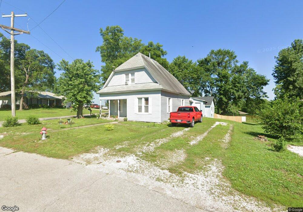
314 W 2nd St Pilot Grove, MO 65276
Estimated Value: $129,298 - $390,000
4
Beds
1
Bath
2,217
Sq Ft
$98/Sq Ft
Est. Value
About This Home
This home is located at 314 W 2nd St, Pilot Grove, MO 65276 and is currently estimated at $216,575, approximately $97 per square foot. 314 W 2nd St is a home located in Cooper County with nearby schools including Pilot Grove Elementary School and Pilot Grove High School.
Ownership History
Date
Name
Owned For
Owner Type
Purchase Details
Closed on
Apr 27, 2023
Sold by
Kieffer Todd and Kieffer Dana
Bought by
Meek Scott and Milligan Christopher
Current Estimated Value
Home Financials for this Owner
Home Financials are based on the most recent Mortgage that was taken out on this home.
Original Mortgage
$122,735
Outstanding Balance
$119,451
Interest Rate
6.6%
Mortgage Type
FHA
Estimated Equity
$97,124
Purchase Details
Closed on
Aug 29, 2006
Sold by
Green Brandey L
Bought by
Kieffer Todd and Mobley-Kieffer Dana
Create a Home Valuation Report for This Property
The Home Valuation Report is an in-depth analysis detailing your home's value as well as a comparison with similar homes in the area
Home Values in the Area
Average Home Value in this Area
Purchase History
| Date | Buyer | Sale Price | Title Company |
|---|---|---|---|
| Meek Scott | -- | None Listed On Document | |
| Kieffer Todd | -- | -- |
Source: Public Records
Mortgage History
| Date | Status | Borrower | Loan Amount |
|---|---|---|---|
| Open | Meek Scott | $122,735 | |
| Closed | Kieffer Todd | $0 |
Source: Public Records
Tax History Compared to Growth
Tax History
| Year | Tax Paid | Tax Assessment Tax Assessment Total Assessment is a certain percentage of the fair market value that is determined by local assessors to be the total taxable value of land and additions on the property. | Land | Improvement |
|---|---|---|---|---|
| 2024 | $631 | $8,760 | $0 | $0 |
| 2023 | $631 | $8,760 | $0 | $0 |
| 2022 | $546 | $8,090 | $0 | $0 |
| 2021 | $541 | $8,020 | $0 | $0 |
| 2020 | $551 | $7,640 | $0 | $0 |
| 2019 | $546 | $7,640 | $0 | $7,640 |
| 2018 | $546 | $7,640 | $0 | $7,640 |
| 2017 | $336 | $4,560 | $0 | $4,560 |
| 2016 | -- | $4,560 | $0 | $0 |
| 2015 | -- | $4,560 | $0 | $0 |
| 2011 | -- | $4,560 | $0 | $0 |
Source: Public Records
Map
Nearby Homes
- 208 College St
- 400 4th St
- 403 Teller St
- 13985 N Hwy
- 10251 Oakland Ln
- TBD Hwy Nn
- 0 M Hwy
- 17346 Olivia Ct
- 17382 Emily Ct
- 13787 Pecan Ct
- 1974 Franklin Dr
- 0 Ferry Rd
- LOT 205 Mid-America Industrial Ct
- LOT 202 Mid-America Industrial Ct
- LOT 17A Mid-America Industrial Ct
- LOT 16 Mid-America Industrial Ct
- Tract 3 K Hwy
- Tract 1 K Hwy
- 304 Herndon St
- Walther Ln Unit Lot WP001