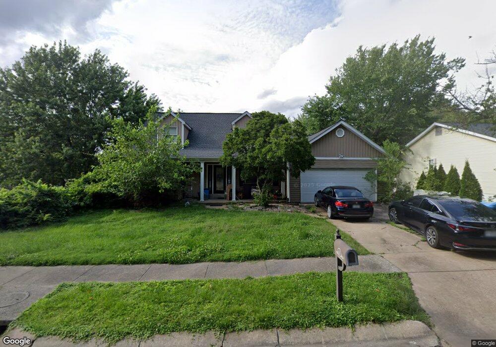
315 Carlson Ave Maryland Heights, MO 63043
Estimated Value: $373,312 - $424,000
3
Beds
3
Baths
2,384
Sq Ft
$166/Sq Ft
Est. Value
About This Home
This home is located at 315 Carlson Ave, Maryland Heights, MO 63043 and is currently estimated at $395,578, approximately $165 per square foot. 315 Carlson Ave is a home located in St. Louis County with nearby schools including Parkwood Elementary, Pattonville Heights Middle School, and Pattonville High School.
Ownership History
Date
Name
Owned For
Owner Type
Purchase Details
Closed on
Jun 28, 2004
Sold by
Wheeler Mark and Wheeler Shelia Harris
Bought by
Engel Karen and Schulte Kurt
Current Estimated Value
Home Financials for this Owner
Home Financials are based on the most recent Mortgage that was taken out on this home.
Original Mortgage
$232,655
Outstanding Balance
$116,012
Interest Rate
6.3%
Mortgage Type
Purchase Money Mortgage
Estimated Equity
$279,566
Create a Home Valuation Report for This Property
The Home Valuation Report is an in-depth analysis detailing your home's value as well as a comparison with similar homes in the area
Home Values in the Area
Average Home Value in this Area
Purchase History
| Date | Buyer | Sale Price | Title Company |
|---|---|---|---|
| Engel Karen | $244,900 | -- |
Source: Public Records
Mortgage History
| Date | Status | Borrower | Loan Amount |
|---|---|---|---|
| Open | Engel Karen | $232,655 |
Source: Public Records
Tax History Compared to Growth
Tax History
| Year | Tax Paid | Tax Assessment Tax Assessment Total Assessment is a certain percentage of the fair market value that is determined by local assessors to be the total taxable value of land and additions on the property. | Land | Improvement |
|---|---|---|---|---|
| 2025 | $4,283 | $65,290 | $14,670 | $50,620 |
| 2024 | $4,283 | $56,380 | $8,250 | $48,130 |
| 2023 | $4,306 | $56,380 | $8,250 | $48,130 |
| 2022 | $4,154 | $49,630 | $11,930 | $37,700 |
| 2021 | $4,196 | $49,630 | $11,930 | $37,700 |
| 2020 | $3,991 | $47,690 | $10,070 | $37,620 |
| 2019 | $3,977 | $47,690 | $10,070 | $37,620 |
| 2018 | $3,677 | $40,350 | $3,380 | $36,970 |
| 2017 | $3,672 | $40,350 | $3,380 | $36,970 |
| 2016 | $3,702 | $39,940 | $6,420 | $33,520 |
| 2015 | $3,661 | $39,940 | $6,420 | $33,520 |
| 2014 | $3,404 | $37,700 | $3,040 | $34,660 |
Source: Public Records
Map
Nearby Homes
- 134 Cumberland Ave
- 20 Millwell Dr
- 11502 Wylwood Dr
- 19 Shumate Ave
- 16 Midland Ave
- 2755 Eldon Ave
- 167 Edgeworth Ave
- 2801 Eldon Ave
- 12597 Fee Rd
- 11342 de Runtz Ave
- 11482 Essex Ave
- 11328 de Runtz Ave
- 11410 Essex Ave
- 2826 Foxwood Dr
- 3069 Smiley Rd
- 3108 Edwards Place Unit 201
- 3114 Edwards Place Unit 304
- 3107 Garnette Dr Unit A7
- 3107 Garnette Dr Unit C12
- 3151 Fort Samuel Ct
- 309 Carlson Ave
- 28 Cumberland Ave
- 22 Cumberland Ave
- 305 Carlson Ave
- 100 Cumberland Ave
- 20 Cumberland Ave
- 39 Lansing Ave
- 301 Carlson Ave
- 43 Lansing Ave
- 103 Lansing Ave
- 35 Lansing Ave
- 106 Cumberland Ave
- 31 Lansing Ave
- 105 Lansing Ave
- 27 Cumberland Ave
- 27 Lansing Ave
- 25 Cumberland Ave
- 402 Carlson Ave
- 23 Cumberland Ave
- 23 Lansing Ave